|
|
|||||||||||||||||
| Point ID: 5856 | Downloads | Plots | Site Data | Code: 1002 |
|
|
|||||||||||||||||
| Download | |
|---|---|
| Site Descriptor Information | Site Time Series Data |
| Link to all available data | |
|
|
| View: | Statistics | Time Series |
| Units: | mm |
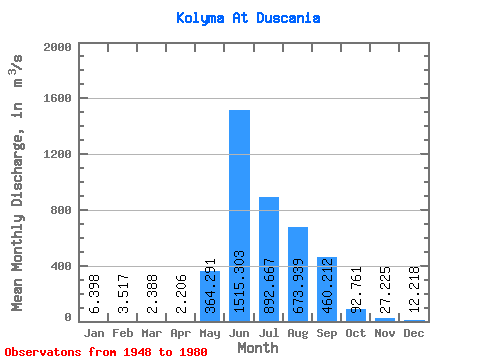
| Statistic | Jan | Feb | Mar | Apr | May | Jun | Jul | Aug | Sep | Oct | Nov | Dec | Annual |
|---|---|---|---|---|---|---|---|---|---|---|---|---|---|
| Mean | 6.40 | 3.52 | 2.39 | 2.21 | 364.29 | 1515.30 | 892.67 | 673.94 | 460.21 | 92.76 | 27.23 | 12.22 | 333.89 |
| Standard Deviation | 4.09 | 2.67 | 1.84 | 1.75 | 351.98 | 809.86 | 383.90 | 268.18 | 255.50 | 33.00 | 9.49 | 5.85 | 83.82 |
| Min | 0.63 | 0.98 | 0.53 | 0.34 | 73.00 | 288.00 | 368.00 | 271.00 | 143.00 | 34.60 | 11.10 | 4.10 | 151.82 |
| Max | 20.70 | 13.00 | 9.07 | 8.03 | 1500.00 | 3830.00 | 2140.00 | 1190.00 | 1390.00 | 164.00 | 52.30 | 32.80 | 490.84 |
| Coefficient of Variation | 0.64 | 0.76 | 0.77 | 0.79 | 0.97 | 0.53 | 0.43 | 0.40 | 0.56 | 0.36 | 0.35 | 0.48 | 0.25 |
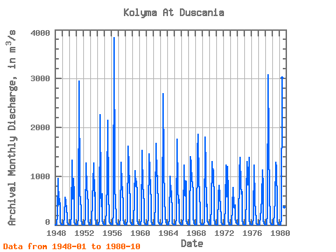
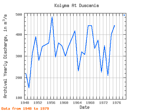
| Year | Jan | Feb | Mar | Apr | May | Jun | Jul | Aug | Sep | Oct | Nov | Dec | Annual | 1948 | 3.58 | 2.30 | 1.34 | 1.28 | 214.00 | 951.00 | 430.00 | 536.00 | 379.00 | 66.80 | 19.50 | 7.09 | 217.66 | 1949 | 2.87 | 1.28 | 0.53 | 0.72 | 175.00 | 571.00 | 485.00 | 315.00 | 188.00 | 59.30 | 17.60 | 5.58 | 151.82 | 1950 | 2.52 | 2.12 | 1.16 | 0.97 | 201.00 | 1330.00 | 540.00 | 954.00 | 621.00 | 68.50 | 18.30 | 8.68 | 312.35 | 1951 | 4.28 | 2.06 | 1.37 | 1.13 | 167.00 | 2950.00 | 607.00 | 572.00 | 245.00 | 104.00 | 20.70 | 6.11 | 390.05 | 1952 | 3.76 | 1.57 | 1.25 | 1.67 | 186.00 | 1270.00 | 739.00 | 666.00 | 378.00 | 86.70 | 22.10 | 7.63 | 280.31 | 1953 | 3.77 | 1.69 | 1.53 | 1.38 | 547.00 | 856.00 | 1270.00 | 591.00 | 670.00 | 158.00 | 25.30 | 11.00 | 344.72 | 1954 | 5.42 | 2.67 | 2.49 | 1.64 | 102.00 | 2260.00 | 712.00 | 374.00 | 632.00 | 108.00 | 29.30 | 11.80 | 353.44 | 1955 | 3.85 | 2.13 | 1.85 | 1.84 | 360.00 | 871.00 | 2140.00 | 620.00 | 213.00 | 58.30 | 28.70 | 20.00 | 360.06 | 1956 | 15.30 | 13.00 | 9.07 | 6.32 | 267.00 | 3830.00 | 890.00 | 368.00 | 287.00 | 62.20 | 24.00 | 8.19 | 481.67 | 1957 | 4.65 | 2.52 | 1.13 | 1.44 | 154.00 | 1290.00 | 822.00 | 734.00 | 371.00 | 115.00 | 39.10 | 12.10 | 295.58 | 1958 | 6.32 | 3.32 | 2.60 | 2.74 | 113.00 | 1620.00 | 1190.00 | 837.00 | 440.00 | 85.20 | 29.30 | 10.30 | 361.65 | 1959 | 3.43 | 1.60 | 1.02 | 1.12 | 595.00 | 1110.00 | 795.00 | 893.00 | 633.00 | 87.50 | 35.60 | 15.40 | 347.64 | 1960 | 7.46 | 3.09 | 1.87 | 2.45 | 141.00 | 1530.00 | 737.00 | 714.00 | 379.00 | 56.10 | 21.10 | 8.63 | 300.14 | 1961 | 3.57 | 1.92 | 1.26 | 0.82 | 171.00 | 1450.00 | 1130.00 | 734.00 | 520.00 | 89.20 | 27.20 | 12.70 | 345.14 | 1962 | 6.79 | 4.10 | 2.86 | 2.77 | 493.00 | 1670.00 | 996.00 | 1010.00 | 260.00 | 78.30 | 35.40 | 17.90 | 381.43 | 1963 | 14.00 | 9.19 | 6.70 | 7.03 | 73.00 | 2690.00 | 1240.00 | 467.00 | 278.00 | 164.00 | 43.40 | 18.80 | 417.59 | 1964 | 9.55 | 3.85 | 2.41 | 1.72 | 136.00 | 994.00 | 645.00 | 689.00 | 225.00 | 39.70 | 20.40 | 9.58 | 231.35 | 1965 | 7.38 | 4.92 | 3.64 | 2.82 | 171.00 | 1750.00 | 787.00 | 448.00 | 524.00 | 80.40 | 32.60 | 23.60 | 319.61 | 1966 | 7.11 | 2.90 | 1.57 | 1.18 | 194.00 | 1220.00 | 616.00 | 597.00 | 903.00 | 96.20 | 37.70 | 15.80 | 307.70 | 1967 | 7.59 | 1.94 | 1.59 | 1.82 | 1400.00 | 1250.00 | 902.00 | 870.00 | 673.00 | 153.00 | 29.00 | 11.40 | 441.78 | 1968 | 4.90 | 3.95 | 2.81 | 2.32 | 1500.00 | 1850.00 | 900.00 | 672.00 | 269.00 | 83.00 | 13.30 | 8.96 | 442.52 | 1969 | 7.99 | 5.40 | 4.29 | 2.50 | 80.60 | 1800.00 | 1170.00 | 378.00 | 416.00 | 100.00 | 52.30 | 16.60 | 336.14 | 1970 | 10.90 | 4.24 | 2.91 | 2.50 | 413.00 | 1300.00 | 1030.00 | 1120.00 | 450.00 | 136.00 | 21.20 | 10.10 | 375.07 | 1971 | 6.06 | 3.31 | 1.82 | 2.16 | 630.00 | 816.00 | 615.00 | 351.00 | 191.00 | 66.60 | 18.10 | 7.92 | 225.75 | 1972 | 3.26 | 2.18 | 2.17 | 2.38 | 434.00 | 1220.00 | 584.00 | 1190.00 | 626.00 | 91.80 | 25.10 | 12.50 | 349.45 | 1973 | 7.95 | 2.21 | 1.63 | 1.31 | 385.00 | 772.00 | 368.00 | 346.00 | 413.00 | 147.00 | 44.70 | 32.80 | 210.13 | 1974 | 20.70 | 9.99 | 6.19 | 8.03 | 1070.00 | 1390.00 | 828.00 | 643.00 | 679.00 | 124.00 | 27.40 | 12.90 | 401.60 | 1975 | 5.24 | 2.08 | 1.06 | 0.76 | 624.00 | 1300.00 | 826.00 | 975.00 | 1390.00 | 115.00 | 24.50 | 14.50 | 439.85 | 1976 | 7.26 | 4.88 | 2.38 | 2.12 | 171.00 | 1220.00 | 501.00 | 271.00 | 143.00 | 34.60 | 11.10 | 6.32 | 197.89 | 1977 | 2.38 | 1.25 | 0.75 | 0.59 | 188.00 | 288.00 | 553.00 | 1130.00 | 798.00 | 107.00 | 35.20 | 12.00 | 259.68 | 1978 | 7.41 | 5.64 | 3.34 | 3.24 | 256.00 | 3070.00 | 1700.00 | 553.00 | 208.00 | 62.80 | 16.50 | 4.10 | 490.84 | 1979 | 0.63 | 0.98 | 1.09 | 1.69 | 281.00 | 496.00 | 1280.00 | 1170.00 | 421.00 | 77.80 | 25.50 | 9.98 | 313.81 | 1980 | 3.26 | 1.78 | 1.13 | 0.34 | 129.00 | 3020.00 | 1430.00 | 452.00 | 364.00 | 99.10 |
|---|
 Return to R-Arctic Net Home Page