|
|
|||||||||||||||||
| Point ID: 5850 | Downloads | Plots | Site Data | Code: 10MB001 |
|
|
|||||||||||||||||
| Download | |
|---|---|
| Site Descriptor Information | Site Time Series Data |
| Link to all available data | |
|
|
| View: | Statistics | Time Series |
| Units: | mm |
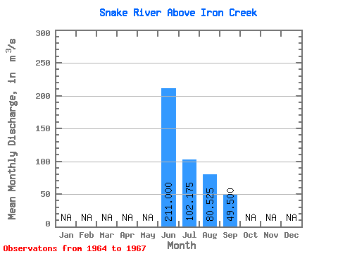
| Statistic | Jan | Feb | Mar | Apr | May | Jun | Jul | Aug | Sep | Oct | Nov | Dec | Annual |
|---|---|---|---|---|---|---|---|---|---|---|---|---|---|
| Mean | 211.00 | 102.17 | 80.53 | 49.50 | |||||||||
| Standard Deviation | 8.20 | 25.30 | 6.58 | ||||||||||
| Min | 211.00 | 92.90 | 44.40 | 42.40 | |||||||||
| Max | 211.00 | 112.00 | 98.40 | 55.40 | |||||||||
| Coefficient of Variation | 0.08 | 0.31 | 0.13 |
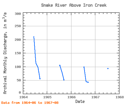
| Year | Jan | Feb | Mar | Apr | May | Jun | Jul | Aug | Sep | Oct | Nov | Dec | Annual | 1964 | 211.00 | 112.00 | 98.40 | 55.40 | 1965 | 105.00 | 81.60 | 50.70 | 1966 | 98.80 | 44.40 | 42.40 | 1967 | 92.90 | 97.70 |
|---|
 Return to R-Arctic Net Home Page