|
|
|||||||||||||||||
| Point ID: 5850 | Downloads | Plots | Site Data | Code: 10MB001 |
|
|
|||||||||||||||||
| Download | |
|---|---|
| Site Descriptor Information | Site Time Series Data |
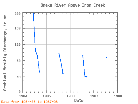
| Link to all available data | |
|
|
| View: | Statistics | Time Series |
| Units: | m3/s |
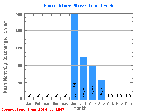
| Statistic | Jan | Feb | Mar | Apr | May | Jun | Jul | Aug | Sep | Oct | Nov | Dec | Annual |
|---|---|---|---|---|---|---|---|---|---|---|---|---|---|
| Mean | 197.44 | 98.78 | 77.85 | 46.32 | |||||||||
| Standard Deviation | 7.93 | 24.46 | 6.16 | ||||||||||
| Min | 197.44 | 89.81 | 42.92 | 39.67 | |||||||||
| Max | 197.44 | 108.28 | 95.13 | 51.84 | |||||||||
| Coefficient of Variation | 0.08 | 0.31 | 0.13 |
| Year | Jan | Feb | Mar | Apr | May | Jun | Jul | Aug | Sep | Oct | Nov | Dec | Annual | 1964 | 197.44 | 108.28 | 95.13 | 51.84 | 1965 | 101.51 | 78.89 | 47.44 | 1966 | 95.52 | 42.92 | 39.67 | 1967 | 89.81 | 94.45 |
|---|
 Return to R-Arctic Net Home Page