|
|
|||||||||||||||||
| Point ID: 5837 | Downloads | Plots | Site Data | Other Close Sites | Code: 09FD001 |
|
|
|||||||||||||||||
| Download | |
|---|---|
| Site Descriptor Information | Site Time Series Data |
| Link to all available data | |
|
|
| View: | Statistics | Time Series |
| Units: | mm |
| Statistic | Jan | Feb | Mar | Apr | May | Jun | Jul | Aug | Sep | Oct | Nov | Dec | Annual |
|---|---|---|---|---|---|---|---|---|---|---|---|---|---|
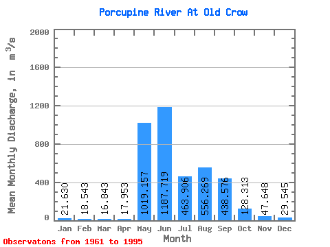
| Mean | 21.63 | 18.54 | 16.84 | 17.95 | 1019.16 | 1187.72 | 463.91 | 556.27 | 438.58 | 128.31 | 47.65 | 29.55 | 322.42 |
| Standard Deviation | 4.27 | 3.79 | 2.76 | 5.17 | 573.35 | 476.33 | 260.60 | 311.25 | 197.10 | 51.20 | 14.82 | 6.76 | 83.12 |
| Min | 16.60 | 13.20 | 12.40 | 11.90 | 18.30 | 440.00 | 150.00 | 53.60 | 104.00 | 41.20 | 24.50 | 18.10 | 182.32 |
| Max | 34.00 | 28.30 | 24.10 | 41.20 | 2140.00 | 2470.00 | 1070.00 | 1090.00 | 917.00 | 233.00 | 90.90 | 48.50 | 501.57 |
| Coefficient of Variation | 0.20 | 0.20 | 0.16 | 0.29 | 0.56 | 0.40 | 0.56 | 0.56 | 0.45 | 0.40 | 0.31 | 0.23 | 0.26 |
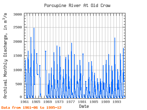
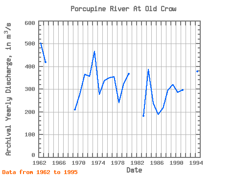
| Year | Jan | Feb | Mar | Apr | May | Jun | Jul | Aug | Sep | Oct | Nov | Dec | Annual | 1961 | 1350.00 | 605.00 | 1030.00 | 767.00 | 174.00 | 24.50 | 18.10 | 1962 | 18.10 | 18.10 | 18.10 | 19.80 | 1200.00 | 1660.00 | 1070.00 | 1060.00 | 716.00 | 151.00 | 45.30 | 42.50 | 501.57 | 1963 | 34.00 | 28.30 | 22.10 | 23.40 | 2140.00 | 1000.00 | 768.00 | 750.00 | 134.00 | 42.80 | 32.90 | 32.30 | 417.32 | 1964 | 26.60 | 22.10 | 17.80 | 18.20 | 178.00 | 2470.00 | 969.00 | 564.00 | 487.00 | 1965 | 1560.00 | 852.00 | 844.00 | 837.00 | 1966 | 1140.00 | 316.00 | 53.60 | 150.00 | 1968 | 1650.00 | 316.00 | 104.00 | 104.00 | 41.20 | 33.90 | 21.80 | 1969 | 16.60 | 15.00 | 13.60 | 14.80 | 458.00 | 440.00 | 167.00 | 869.00 | 392.00 | 60.80 | 34.10 | 28.70 | 209.13 | 1970 | 17.70 | 14.60 | 15.70 | 16.60 | 669.00 | 1070.00 | 488.00 | 412.00 | 447.00 | 85.80 | 47.40 | 31.20 | 276.25 | 1971 | 19.40 | 17.40 | 16.20 | 13.90 | 1610.00 | 1000.00 | 337.00 | 649.00 | 515.00 | 123.00 | 39.40 | 21.40 | 363.48 | 1972 | 18.10 | 20.20 | 17.90 | 14.20 | 474.00 | 1840.00 | 536.00 | 538.00 | 630.00 | 113.00 | 49.40 | 29.40 | 356.68 | 1973 | 22.10 | 21.00 | 16.50 | 15.60 | 1800.00 | 1170.00 | 663.00 | 1090.00 | 556.00 | 161.00 | 46.30 | 25.20 | 465.56 | 1974 | 19.80 | 15.40 | 15.00 | 14.80 | 459.00 | 539.00 | 506.00 | 1020.00 | 381.00 | 220.00 | 87.80 | 37.30 | 276.26 | 1975 | 19.70 | 16.00 | 12.40 | 11.90 | 1330.00 | 1450.00 | 256.00 | 362.00 | 405.00 | 115.00 | 34.40 | 21.50 | 336.16 | 1976 | 18.90 | 16.50 | 14.70 | 14.70 | 1520.00 | 1190.00 | 337.00 | 587.00 | 231.00 | 164.00 | 54.60 | 32.70 | 348.43 | 1977 | 26.10 | 23.60 | 22.00 | 19.80 | 1350.00 | 1940.00 | 309.00 | 127.00 | 186.00 | 172.00 | 51.80 | 27.60 | 354.57 | 1978 | 22.10 | 19.20 | 17.30 | 16.70 | 32.60 | 1540.00 | 443.00 | 176.00 | 330.00 | 176.00 | 68.80 | 38.50 | 240.02 | 1979 | 22.80 | 13.20 | 14.50 | 15.50 | 1170.00 | 697.00 | 524.00 | 577.00 | 506.00 | 233.00 | 90.90 | 48.50 | 326.03 | 1980 | 27.50 | 20.30 | 17.70 | 19.00 | 1340.00 | 963.00 | 281.00 | 866.00 | 585.00 | 184.00 | 64.70 | 35.80 | 367.00 | 1981 | 31.10 | 27.50 | 24.10 | 22.00 | 1550.00 | 118.00 | 52.10 | 36.70 | 1982 | 17.10 | 13.70 | 12.90 | 12.90 | 582.00 | 376.00 | 161.00 | 45.70 | 29.50 | 1983 | 20.30 | 16.40 | 15.60 | 15.70 | 91.80 | 1260.00 | 211.00 | 158.00 | 235.00 | 96.10 | 43.70 | 24.20 | 182.32 | 1984 | 17.60 | 15.50 | 14.40 | 15.80 | 1300.00 | 979.00 | 967.00 | 889.00 | 320.00 | 67.10 | 31.80 | 25.40 | 386.88 | 1985 | 23.40 | 21.20 | 19.20 | 17.40 | 727.00 | 891.00 | 292.00 | 149.00 | 451.00 | 172.00 | 46.40 | 29.30 | 236.57 | 1986 | 24.10 | 22.30 | 18.00 | 16.30 | 18.30 | 698.00 | 313.00 | 558.00 | 406.00 | 107.00 | 42.20 | 27.00 | 187.52 | 1987 | 21.70 | 19.50 | 17.00 | 14.70 | 456.00 | 681.00 | 150.00 | 598.00 | 473.00 | 100.00 | 42.00 | 22.90 | 216.32 | 1988 | 19.00 | 17.60 | 17.70 | 20.40 | 1160.00 | 781.00 | 311.00 | 534.00 | 541.00 | 92.80 | 34.20 | 23.10 | 295.98 | 1989 | 19.30 | 17.40 | 16.50 | 17.50 | 1040.00 | 1340.00 | 434.00 | 388.00 | 375.00 | 105.00 | 48.90 | 26.20 | 318.98 | 1990 | 18.00 | 14.30 | 12.80 | 19.70 | 1540.00 | 780.00 | 185.00 | 310.00 | 377.00 | 95.10 | 40.00 | 27.70 | 284.97 | 1991 | 22.50 | 20.00 | 17.90 | 16.90 | 1130.00 | 668.00 | 161.00 | 963.00 | 334.00 | 157.00 | 39.00 | 24.60 | 296.16 | 1992 | 18.50 | 16.00 | 19.40 | 20.40 | 909.00 | 2120.00 | 262.00 | 345.00 | 231.00 | 73.50 | 41.00 | 26.50 | 340.19 | 1993 | 18.30 | 14.90 | 14.80 | 19.00 | 1020.00 | 850.00 | 304.00 | 331.00 | 635.00 | 99.70 | 54.10 | 36.50 | 283.11 | 1994 | 26.60 | 21.70 | 18.40 | 19.80 | 1560.00 | 1150.00 | 806.00 | 298.00 | 443.00 | 99.80 | 49.40 | 31.10 | 376.98 | 1995 | 21.90 | 17.40 | 15.10 | 41.20 | 1760.00 | 1140.00 | 706.00 | 601.00 | 917.00 | 217.00 | 60.40 | 32.70 | 460.81 |
|---|
| Other Close Sites | ||||||
|---|---|---|---|---|---|---|
| PointID | Latitude | Longitude | Drainage Area | Source | Name | |
| 5836 | "OLD CROW RIVER NEAR THE MOUTH" | 67.63 | 1884847 | Hydat | ||
 Return to R-Arctic Net Home Page