|
|
|||||||||||||||||
| Point ID: 5834 | Downloads | Plots | Site Data | Code: 09FB001 |
|
|
|||||||||||||||||
| Download | |
|---|---|
| Site Descriptor Information | Site Time Series Data |
| Link to all available data | |
|
|
| View: | Statistics | Time Series |
| Units: | mm |
| Statistic | Jan | Feb | Mar | Apr | May | Jun | Jul | Aug | Sep | Oct | Nov | Dec | Annual |
|---|---|---|---|---|---|---|---|---|---|---|---|---|---|
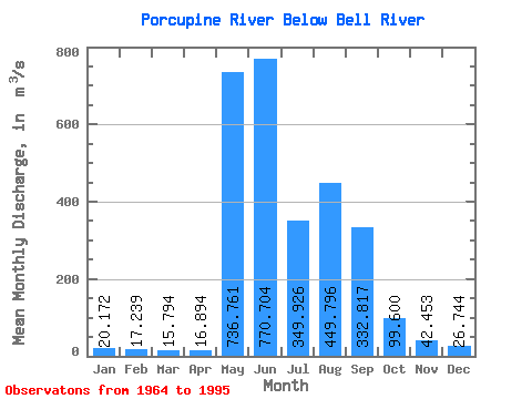
| Mean | 20.17 | 17.24 | 15.79 | 16.89 | 736.76 | 770.70 | 349.93 | 449.80 | 332.82 | 99.60 | 42.45 | 26.74 | 231.30 |
| Standard Deviation | 3.82 | 3.34 | 2.50 | 3.51 | 401.10 | 323.02 | 224.69 | 225.55 | 130.62 | 37.91 | 13.80 | 6.47 | 54.15 |
| Min | 14.60 | 12.90 | 12.20 | 12.60 | 14.70 | 250.00 | 120.00 | 90.50 | 95.70 | 42.90 | 27.60 | 17.60 | 133.83 |
| Max | 30.10 | 25.90 | 22.90 | 27.40 | 1230.00 | 1650.00 | 1020.00 | 981.00 | 674.00 | 173.00 | 83.90 | 44.80 | 323.53 |
| Coefficient of Variation | 0.19 | 0.19 | 0.16 | 0.21 | 0.54 | 0.42 | 0.64 | 0.50 | 0.39 | 0.38 | 0.33 | 0.24 | 0.23 |
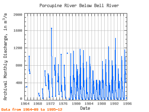
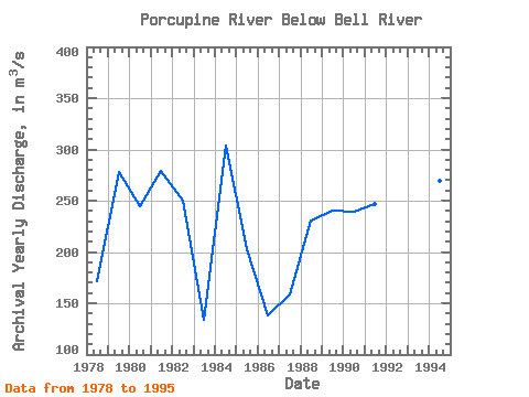
| Year | Jan | Feb | Mar | Apr | May | Jun | Jul | Aug | Sep | Oct | Nov | Dec | Annual | 1964 | 304.00 | 1965 | 1010.00 | 673.00 | 709.00 | 616.00 | 1968 | 153.00 | 90.50 | 95.70 | 1969 | 251.00 | 42.90 | 1970 | 670.00 | 422.00 | 367.00 | 332.00 | 1971 | 598.00 | 244.00 | 570.00 | 330.00 | 64.80 | 1972 | 1650.00 | 372.00 | 427.00 | 500.00 | 80.90 | 1973 | 797.00 | 564.00 | 981.00 | 387.00 | 92.30 | 1974 | 432.00 | 412.00 | 822.00 | 270.00 | 135.00 | 1975 | 1050.00 | 190.00 | 345.00 | 316.00 | 75.40 | 1976 | 802.00 | 224.00 | 524.00 | 177.00 | 102.00 | 43.50 | 1977 | 1080.00 | 1978 | 21.80 | 18.60 | 15.50 | 13.90 | 35.30 | 1070.00 | 167.00 | 159.00 | 299.00 | 158.00 | 64.90 | 36.60 | 171.63 | 1979 | 21.50 | 12.90 | 14.00 | 14.80 | 1130.00 | 514.00 | 417.00 | 505.00 | 407.00 | 173.00 | 83.90 | 44.80 | 278.16 | 1980 | 25.10 | 19.10 | 16.30 | 16.80 | 815.00 | 498.00 | 201.00 | 705.00 | 409.00 | 141.00 | 60.90 | 34.20 | 245.12 | 1981 | 30.10 | 25.90 | 22.90 | 21.00 | 1170.00 | 250.00 | 1020.00 | 473.00 | 173.00 | 87.80 | 42.20 | 30.70 | 278.88 | 1982 | 14.60 | 12.90 | 12.20 | 12.60 | 554.00 | 1140.00 | 310.00 | 448.00 | 309.00 | 126.00 | 37.60 | 24.00 | 250.07 | 1983 | 17.60 | 14.70 | 14.10 | 14.10 | 55.70 | 875.00 | 146.00 | 150.00 | 178.00 | 78.90 | 38.60 | 23.30 | 133.83 | 1984 | 17.30 | 15.30 | 14.20 | 15.60 | 1010.00 | 665.00 | 827.00 | 721.00 | 244.00 | 59.60 | 30.60 | 25.10 | 303.73 | 1985 | 21.70 | 18.50 | 16.80 | 15.90 | 681.00 | 668.00 | 192.00 | 148.00 | 441.00 | 169.00 | 41.10 | 24.40 | 203.12 | 1986 | 19.90 | 16.50 | 14.10 | 12.80 | 14.70 | 456.00 | 239.00 | 460.00 | 299.00 | 73.70 | 30.40 | 21.90 | 138.17 | 1987 | 19.70 | 18.60 | 16.10 | 13.80 | 262.00 | 457.00 | 120.00 | 444.00 | 399.00 | 96.90 | 35.40 | 17.60 | 158.34 | 1988 | 15.60 | 15.40 | 14.80 | 17.50 | 892.00 | 522.00 | 278.00 | 462.00 | 427.00 | 76.30 | 27.60 | 19.30 | 230.62 | 1989 | 16.80 | 15.90 | 15.60 | 16.50 | 725.00 | 937.00 | 334.00 | 349.00 | 313.00 | 92.60 | 43.60 | 24.30 | 240.28 | 1990 | 17.30 | 13.80 | 12.60 | 19.40 | 1230.00 | 598.00 | 185.00 | 301.00 | 344.00 | 86.80 | 37.60 | 26.60 | 239.34 | 1991 | 22.10 | 20.00 | 17.80 | 17.60 | 905.00 | 538.00 | 160.00 | 789.00 | 296.00 | 137.00 | 34.80 | 23.10 | 246.70 | 1992 | 18.00 | 15.60 | 18.20 | 19.00 | 888.00 | 1420.00 | 203.00 | 232.00 | 112.00 | 46.60 | 32.90 | 24.40 | 252.47 | 1993 | 17.90 | 15.10 | 14.20 | 18.00 | 724.00 | 478.00 | 273.00 | 291.00 | 435.00 | 67.50 | 40.20 | 27.20 | 200.09 | 1994 | 24.00 | 21.50 | 16.90 | 17.40 | 1010.00 | 821.00 | 616.00 | 254.00 | 314.00 | 77.00 | 34.00 | 25.80 | 269.30 | 1995 | 22.10 | 20.00 | 18.00 | 27.40 | 1160.00 | 813.00 | 506.00 | 418.00 | 674.00 | 149.00 | 46.80 | 28.10 | 323.53 |
|---|
 Return to R-Arctic Net Home Page