|
|
|||||||||||||||||
| Point ID: 5834 | Downloads | Plots | Site Data | Code: 09FB001 |
|
|
|||||||||||||||||
| Download | |
|---|---|
| Site Descriptor Information | Site Time Series Data |
| Link to all available data | |
| View: | Time Series | All |
| Units: | mm |
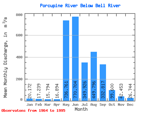
| Statistic | Jan | Feb | Mar | Apr | May | Jun | Jul | Aug | Sep | Oct | Nov | Dec | Annual |
|---|---|---|---|---|---|---|---|---|---|---|---|---|---|
| Mean | 20.17 | 17.24 | 15.79 | 16.89 | 736.76 | 770.70 | 349.93 | 449.80 | 332.82 | 99.60 | 42.45 | 26.74 | 231.30 |
| Standard Deviation | 3.82 | 3.34 | 2.50 | 3.51 | 401.10 | 323.02 | 224.69 | 225.55 | 130.62 | 37.91 | 13.80 | 6.47 | 54.15 |
| Min | 14.60 | 12.90 | 12.20 | 12.60 | 14.70 | 250.00 | 120.00 | 90.50 | 95.70 | 42.90 | 27.60 | 17.60 | 133.83 |
| Max | 30.10 | 25.90 | 22.90 | 27.40 | 1230.00 | 1650.00 | 1020.00 | 981.00 | 674.00 | 173.00 | 83.90 | 44.80 | 323.53 |
| Coefficient of Variation | 0.19 | 0.19 | 0.16 | 0.21 | 0.54 | 0.42 | 0.64 | 0.50 | 0.39 | 0.38 | 0.33 | 0.24 | 0.23 |
 Return to R-Arctic Net Home Page