|
|
|||||||||||||||||
| Point ID: 5809 | Downloads | Plots | Site Data | Code: 09BC004 |
|
|
|||||||||||||||||
| Download | |
|---|---|
| Site Descriptor Information | Site Time Series Data |
| Link to all available data | |
|
|
| View: | Statistics | Time Series |
| Units: | mm |
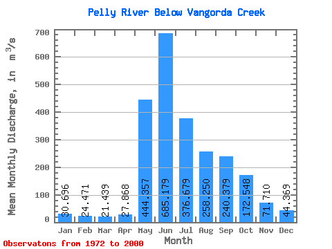
| Statistic | Jan | Feb | Mar | Apr | May | Jun | Jul | Aug | Sep | Oct | Nov | Dec | Annual |
|---|---|---|---|---|---|---|---|---|---|---|---|---|---|
| Mean | 30.70 | 24.47 | 21.44 | 27.87 | 444.36 | 685.18 | 376.68 | 258.25 | 240.38 | 172.55 | 71.71 | 44.37 | 200.31 |
| Standard Deviation | 7.51 | 5.63 | 4.60 | 7.41 | 117.98 | 179.79 | 119.51 | 89.57 | 99.50 | 64.22 | 17.98 | 11.11 | 34.68 |
| Min | 14.50 | 10.90 | 10.00 | 14.20 | 183.00 | 400.00 | 156.00 | 111.00 | 102.00 | 87.40 | 46.20 | 24.30 | 135.33 |
| Max | 51.00 | 41.10 | 34.90 | 44.20 | 715.00 | 1170.00 | 636.00 | 484.00 | 485.00 | 383.00 | 106.00 | 68.50 | 265.48 |
| Coefficient of Variation | 0.24 | 0.23 | 0.21 | 0.27 | 0.27 | 0.26 | 0.32 | 0.35 | 0.41 | 0.37 | 0.25 | 0.25 | 0.17 |
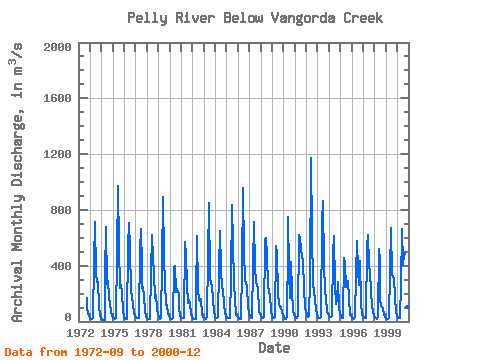
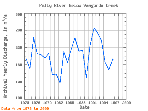
| Year | Jan | Feb | Mar | Apr | May | Jun | Jul | Aug | Sep | Oct | Nov | Dec | Annual | 1972 | 172.00 | 99.50 | 56.90 | 40.30 | 1973 | 24.20 | 19.00 | 17.70 | 21.90 | 435.00 | 712.00 | 345.00 | 281.00 | 280.00 | 112.00 | 47.50 | 24.30 | 193.30 | 1974 | 14.50 | 10.90 | 10.00 | 14.20 | 343.00 | 680.00 | 270.00 | 289.00 | 174.00 | 128.00 | 66.70 | 43.10 | 170.28 | 1975 | 28.00 | 22.90 | 21.30 | 25.10 | 487.00 | 972.00 | 533.00 | 241.00 | 259.00 | 214.00 | 72.60 | 36.60 | 242.71 | 1976 | 28.10 | 23.70 | 20.50 | 21.30 | 532.00 | 704.00 | 520.00 | 223.00 | 168.00 | 129.00 | 61.00 | 38.10 | 205.72 | 1977 | 31.40 | 27.20 | 24.90 | 26.00 | 511.00 | 662.00 | 390.00 | 243.00 | 245.00 | 174.00 | 75.80 | 35.10 | 203.78 | 1978 | 24.70 | 17.60 | 15.50 | 18.70 | 345.00 | 620.00 | 456.00 | 338.00 | 172.00 | 193.00 | 93.80 | 48.20 | 195.21 | 1979 | 28.80 | 22.40 | 21.40 | 25.00 | 422.00 | 892.00 | 453.00 | 278.00 | 117.00 | 120.00 | 56.40 | 39.10 | 206.26 | 1980 | 26.40 | 20.80 | 20.30 | 24.30 | 388.00 | 400.00 | 214.00 | 236.00 | 215.00 | 199.00 | 96.30 | 39.40 | 156.62 | 1981 | 28.00 | 23.70 | 22.40 | 23.20 | 567.00 | 466.00 | 272.00 | 131.00 | 156.00 | 128.00 | 53.30 | 32.40 | 158.58 | 1982 | 21.30 | 17.00 | 14.80 | 20.60 | 183.00 | 615.00 | 232.00 | 153.00 | 148.00 | 160.00 | 54.10 | 29.30 | 137.34 | 1983 | 23.80 | 23.50 | 20.10 | 31.70 | 464.00 | 847.00 | 315.00 | 267.00 | 265.00 | 152.00 | 78.10 | 42.40 | 210.80 | 1984 | 30.00 | 26.30 | 23.20 | 29.60 | 385.00 | 646.00 | 376.00 | 241.00 | 231.00 | 128.00 | 63.70 | 37.10 | 184.74 | 1985 | 27.00 | 23.60 | 22.70 | 24.60 | 321.00 | 837.00 | 548.00 | 277.00 | 260.00 | 165.00 | 49.90 | 36.40 | 216.02 | 1986 | 31.20 | 26.80 | 18.80 | 16.50 | 382.00 | 957.00 | 490.00 | 304.00 | 267.00 | 252.00 | 105.00 | 59.30 | 242.47 | 1987 | 38.60 | 31.50 | 23.50 | 26.70 | 405.00 | 713.00 | 389.00 | 278.00 | 270.00 | 236.00 | 74.40 | 55.30 | 211.75 | 1988 | 37.00 | 26.90 | 22.80 | 29.00 | 587.00 | 598.00 | 466.00 | 264.00 | 203.00 | 193.00 | 80.50 | 59.40 | 213.88 | 1989 | 43.70 | 28.30 | 21.60 | 34.30 | 539.00 | 483.00 | 195.00 | 126.00 | 102.00 | 102.00 | 67.50 | 47.10 | 149.12 | 1990 | 35.70 | 21.00 | 18.40 | 34.20 | 543.00 | 751.00 | 361.00 | 170.00 | 426.00 | 212.00 | 80.50 | 49.00 | 225.15 | 1991 | 33.30 | 27.50 | 24.20 | 44.20 | 622.00 | 595.00 | 519.00 | 471.00 | 432.00 | 243.00 | 106.00 | 68.50 | 265.48 | 1992 | 51.00 | 41.10 | 34.90 | 38.00 | 303.00 | 1170.00 | 636.00 | 269.00 | 217.00 | 150.00 | 86.50 | 52.30 | 254.07 | 1993 | 34.70 | 28.00 | 25.50 | 34.40 | 715.00 | 863.00 | 388.00 | 233.00 | 209.00 | 171.00 | 64.60 | 61.10 | 235.61 | 1994 | 40.30 | 30.70 | 28.80 | 36.40 | 486.00 | 616.00 | 259.00 | 125.00 | 156.00 | 285.00 | 93.80 | 59.50 | 184.71 | 1995 | 36.30 | 27.60 | 23.00 | 26.00 | 458.00 | 412.00 | 249.00 | 255.00 | 288.00 | 167.00 | 46.20 | 36.70 | 168.73 | 1996 | 27.90 | 23.40 | 19.60 | 38.70 | 336.00 | 576.00 | 367.00 | 264.00 | 432.00 | 131.00 | 55.30 | 43.50 | 192.87 | 1997 | 34.80 | 28.80 | 24.30 | 24.00 | 538.00 | 619.00 | 408.00 | 358.00 | 210.00 | 112.00 | 71.50 | 42.30 | 205.89 | 1998 | 30.10 | 24.00 | 20.80 | 40.20 | 519.00 | 444.00 | 156.00 | 111.00 | 107.00 | 87.40 | 52.00 | 32.50 | 135.33 | 1999 | 20.70 | 17.30 | 16.20 | 27.00 | 356.00 | 669.00 | 334.00 | 321.00 | 305.00 | 178.00 | 66.70 | 37.20 | 195.68 | 2000 | 28.00 | 23.70 | 23.10 | 24.50 | 270.00 | 666.00 | 406.00 | 484.00 | 485.00 | 383.00 | 103.00 | 61.20 | 246.46 |
|---|
 Return to R-Arctic Net Home Page