|
|
|||||||||||||||||
| Point ID: 5809 | Downloads | Plots | Site Data | Code: 09BC004 |
|
|
|||||||||||||||||
| Download | |
|---|---|
| Site Descriptor Information | Site Time Series Data |
| Link to all available data | |
| View: | Time Series | All |
| Units: | mm |
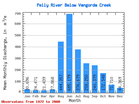
| Statistic | Jan | Feb | Mar | Apr | May | Jun | Jul | Aug | Sep | Oct | Nov | Dec | Annual |
|---|---|---|---|---|---|---|---|---|---|---|---|---|---|
| Mean | 30.70 | 24.47 | 21.44 | 27.87 | 444.36 | 685.18 | 376.68 | 258.25 | 240.38 | 172.55 | 71.71 | 44.37 | 200.31 |
| Standard Deviation | 7.51 | 5.63 | 4.60 | 7.41 | 117.98 | 179.79 | 119.51 | 89.57 | 99.50 | 64.22 | 17.98 | 11.11 | 34.68 |
| Min | 14.50 | 10.90 | 10.00 | 14.20 | 183.00 | 400.00 | 156.00 | 111.00 | 102.00 | 87.40 | 46.20 | 24.30 | 135.33 |
| Max | 51.00 | 41.10 | 34.90 | 44.20 | 715.00 | 1170.00 | 636.00 | 484.00 | 485.00 | 383.00 | 106.00 | 68.50 | 265.48 |
| Coefficient of Variation | 0.24 | 0.23 | 0.21 | 0.27 | 0.27 | 0.26 | 0.32 | 0.35 | 0.41 | 0.37 | 0.25 | 0.25 | 0.17 |
 Return to R-Arctic Net Home Page