|
|
|||||||||||||||||
| Point ID: 5808 | Downloads | Plots | Site Data | Code: 09BC003 |
|
|
|||||||||||||||||
| Download | |
|---|---|
| Site Descriptor Information | Site Time Series Data |
| Link to all available data | |
|
|
| View: | Statistics | Time Series |
| Units: | mm |
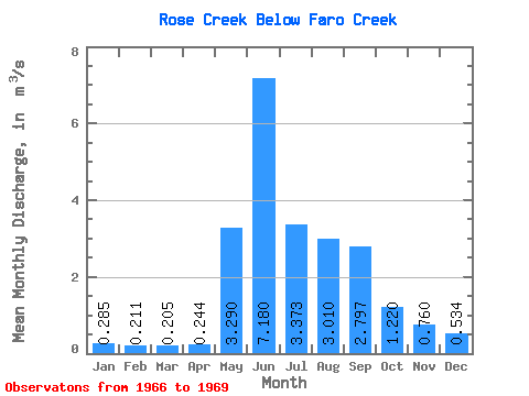
| Statistic | Jan | Feb | Mar | Apr | May | Jun | Jul | Aug | Sep | Oct | Nov | Dec | Annual |
|---|---|---|---|---|---|---|---|---|---|---|---|---|---|
| Mean | 0.28 | 0.21 | 0.20 | 0.24 | 3.29 | 7.18 | 3.37 | 3.01 | 2.80 | 1.22 | 0.76 | 0.53 | 2.35 |
| Standard Deviation | 0.02 | 0.01 | 0.01 | 0.01 | 1.02 | 4.00 | 1.07 | 1.74 | 2.32 | 0.24 | 0.22 | 0.15 | |
| Min | 0.27 | 0.21 | 0.20 | 0.23 | 2.57 | 3.80 | 2.55 | 1.78 | 1.05 | 1.05 | 0.60 | 0.43 | 2.35 |
| Max | 0.30 | 0.21 | 0.21 | 0.25 | 4.01 | 11.60 | 4.58 | 4.24 | 5.43 | 1.39 | 0.92 | 0.64 | 2.35 |
| Coefficient of Variation | 0.06 | 0.03 | 0.03 | 0.05 | 0.31 | 0.56 | 0.32 | 0.58 | 0.83 | 0.20 | 0.29 | 0.28 |
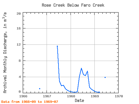
| Year | Jan | Feb | Mar | Apr | May | Jun | Jul | Aug | Sep | Oct | Nov | Dec | Annual | 1966 | 1.05 | 1967 | 11.60 | 2.99 | 1.78 | 1.91 | 1.05 | 0.60 | 0.43 | 1968 | 0.27 | 0.21 | 0.20 | 0.23 | 4.01 | 6.14 | 4.58 | 4.24 | 5.43 | 1.39 | 0.92 | 0.64 | 2.35 | 1969 | 0.30 | 0.21 | 0.21 | 0.25 | 2.57 | 3.80 | 2.55 |
|---|
 Return to R-Arctic Net Home Page