|
|
|||||||||||||||||
| Point ID: 5416 | Downloads | Plots | Site Data | Code: 05JM015 |
|
|
|||||||||||||||||
| Download | |
|---|---|
| Site Descriptor Information | Site Time Series Data |
| Link to all available data | |
| View: | Time Series | All |
| Units: | m3/s |
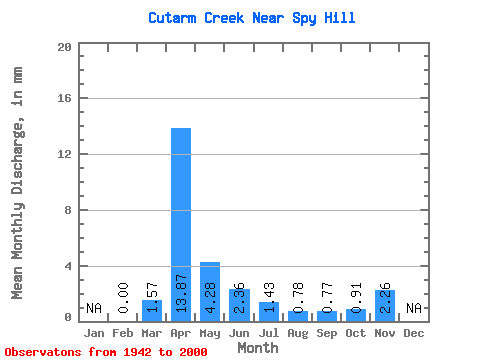
| Statistic | Jan | Feb | Mar | Apr | May | Jun | Jul | Aug | Sep | Oct | Nov | Dec | Annual |
|---|---|---|---|---|---|---|---|---|---|---|---|---|---|
| Mean | 0.00 | 0.82 | 7.21 | 2.22 | 1.23 | 0.74 | 0.41 | 0.40 | 0.47 | 1.17 | |||
| Standard Deviation | 0.95 | 7.23 | 3.11 | 2.38 | 1.63 | 0.78 | 0.56 | 0.59 | 1.11 | ||||
| Min | 0.00 | 0.00 | 0.12 | 0.04 | 0.00 | 0.00 | 0.00 | 0.00 | 0.00 | 0.39 | |||
| Max | 0.00 | 4.83 | 39.25 | 18.11 | 17.02 | 12.34 | 5.14 | 2.78 | 3.28 | 1.96 | |||
| Coefficient of Variation | 1.17 | 1.00 | 1.40 | 1.94 | 2.19 | 1.92 | 1.42 | 1.26 | 0.94 |
 Return to R-Arctic Net Home Page