|
|
|||||||||||||||||
| Point ID: 5416 | Downloads | Plots | Site Data | Code: 05JM015 |
|
|
|||||||||||||||||
| Download | |
|---|---|
| Site Descriptor Information | Site Time Series Data |
| Link to all available data | |
| View: | Time Series | All |
| Units: | mm |
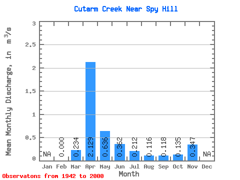
| Statistic | Jan | Feb | Mar | Apr | May | Jun | Jul | Aug | Sep | Oct | Nov | Dec | Annual |
|---|---|---|---|---|---|---|---|---|---|---|---|---|---|
| Mean | 0.00 | 0.23 | 2.13 | 0.64 | 0.36 | 0.21 | 0.12 | 0.12 | 0.14 | 0.35 | |||
| Standard Deviation | 0.27 | 2.14 | 0.89 | 0.70 | 0.47 | 0.22 | 0.17 | 0.17 | 0.33 | ||||
| Min | 0.00 | 0.00 | 0.03 | 0.01 | 0.00 | 0.00 | 0.00 | 0.00 | 0.00 | 0.12 | |||
| Max | 0.00 | 1.38 | 11.60 | 5.18 | 5.03 | 3.53 | 1.47 | 0.82 | 0.94 | 0.58 | |||
| Coefficient of Variation | 1.17 | 1.00 | 1.40 | 1.94 | 2.19 | 1.92 | 1.42 | 1.26 | 0.94 |
 Return to R-Arctic Net Home Page