|
|
|||||||||||||||||
| Point ID: 5371 | Downloads | Plots | Site Data | Code: 05JF009 |
|
|
|||||||||||||||||
| Download | |
|---|---|
| Site Descriptor Information | Site Time Series Data |
| Link to all available data | |
|
|
| View: | Statistics | Time Series |
| Units: | mm |
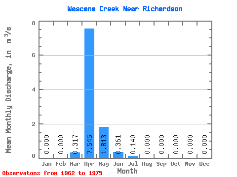
| Statistic | Jan | Feb | Mar | Apr | May | Jun | Jul | Aug | Sep | Oct | Nov | Dec | Annual |
|---|---|---|---|---|---|---|---|---|---|---|---|---|---|
| Mean | 0.00 | 0.00 | 0.32 | 7.54 | 1.81 | 0.36 | 0.14 | 0.00 | 0.00 | 0.00 | 0.00 | 0.00 | 0.08 |
| Standard Deviation | 0.00 | 0.00 | 0.60 | 8.71 | 4.72 | 0.79 | 0.36 | 0.00 | 0.00 | 0.00 | 0.00 | 0.00 | 0.10 |
| Min | 0.00 | 0.00 | 0.00 | 0.00 | 0.00 | 0.00 | 0.00 | 0.00 | 0.00 | 0.00 | 0.00 | 0.00 | 0.01 |
| Max | 0.00 | 0.00 | 1.75 | 27.30 | 16.60 | 2.01 | 1.18 | 0.00 | 0.00 | 0.00 | 0.00 | 0.00 | 0.15 |
| Coefficient of Variation | 1.88 | 1.16 | 2.60 | 2.19 | 2.56 | 1.16 |
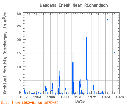
| Year | Jan | Feb | Mar | Apr | May | Jun | Jul | Aug | Sep | Oct | Nov | Dec | Annual | 1962 | 0.00 | 0.00 | 0.00 | 1.78 | 0.00 | 0.00 | 0.00 | 0.00 | 0.00 | 0.00 | 0.00 | 0.00 | 0.15 | 1963 | 0.00 | 0.00 | 0.06 | 0.03 | 0.00 | 0.06 | 0.02 | 0.00 | 0.00 | 0.00 | 0.00 | 0.00 | 0.01 | 1964 | 0.00 | 0.59 | 0.01 | 0.00 | 0.32 | 0.00 | 0.00 | 0.00 | 1965 | 0.00 | 2.83 | 0.58 | 2.01 | 0.01 | 0.00 | 0.00 | 0.00 | 1966 | 1.24 | 3.93 | 0.11 | 0.00 | 0.00 | 0.00 | 0.00 | 0.00 | 1967 | 0.00 | 8.43 | 0.65 | 0.00 | 0.00 | 0.00 | 0.00 | 0.00 | 1968 | 1.75 | 0.32 | 1969 | 0.00 | 15.30 | 0.68 | 0.00 | 0.00 | 1970 | 0.00 | 6.14 | 2.73 | 1.90 | 0.00 | 0.00 | 0.00 | 0.00 | 1971 | 0.00 | 20.70 | 0.34 | 0.00 | 0.00 | 0.00 | 0.00 | 0.00 | 1972 | 0.72 | 3.08 | 0.06 | 0.00 | 0.00 | 0.00 | 0.00 | 0.00 | 1973 | 0.03 | 0.00 | 0.00 | 0.00 | 1.18 | 0.00 | 0.00 | 0.00 | 1974 | 27.30 | 1975 | 15.20 | 16.60 |
|---|
 Return to R-Arctic Net Home Page