|
|
|||||||||||||||||
| Point ID: 5234 | Downloads | Plots | Site Data | Code: 05HA009 |
|
|
|||||||||||||||||
| Download | |
|---|---|
| Site Descriptor Information | Site Time Series Data |
| Link to all available data | |
| View: | Time Series | All |
| Units: | m3/s |
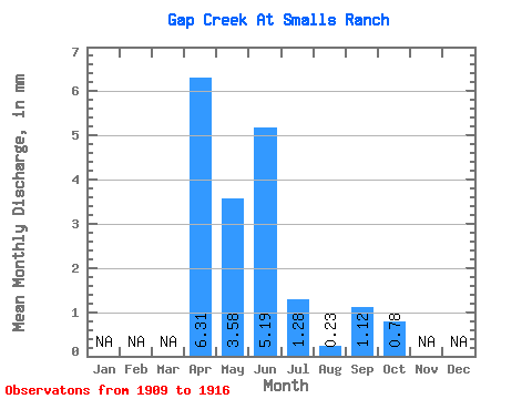
| Statistic | Jan | Feb | Mar | Apr | May | Jun | Jul | Aug | Sep | Oct | Nov | Dec | Annual |
|---|---|---|---|---|---|---|---|---|---|---|---|---|---|
| Mean | 6.03 | 3.42 | 4.96 | 1.22 | 0.22 | 1.07 | 0.75 | ||||||
| Standard Deviation | 4.97 | 3.91 | 6.46 | 1.52 | 0.34 | 2.89 | 1.36 | ||||||
| Min | 0.10 | 0.03 | 0.00 | 0.00 | 0.00 | 0.00 | 0.00 | ||||||
| Max | 12.90 | 9.74 | 13.15 | 3.74 | 0.94 | 8.21 | 4.00 | ||||||
| Coefficient of Variation | 0.82 | 1.14 | 1.30 | 1.25 | 1.54 | 2.69 | 1.82 |
 Return to R-Arctic Net Home Page