|
|
|||||||||||||||||
| Point ID: 5234 | Downloads | Plots | Site Data | Code: 05HA009 |
|
|
|||||||||||||||||
| Download | |
|---|---|
| Site Descriptor Information | Site Time Series Data |
| Link to all available data | |
| View: | Time Series | All |
| Units: | mm |
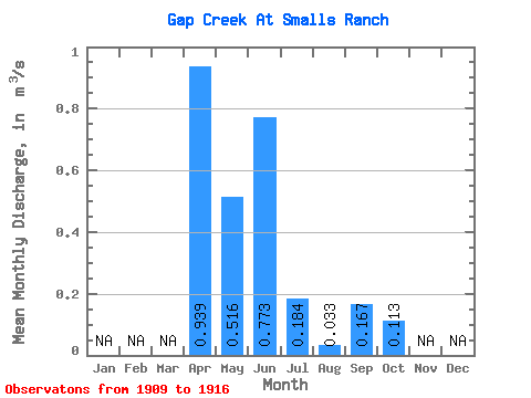
| Statistic | Jan | Feb | Mar | Apr | May | Jun | Jul | Aug | Sep | Oct | Nov | Dec | Annual |
|---|---|---|---|---|---|---|---|---|---|---|---|---|---|
| Mean | 0.94 | 0.52 | 0.77 | 0.18 | 0.03 | 0.17 | 0.11 | ||||||
| Standard Deviation | 0.78 | 0.59 | 1.01 | 0.23 | 0.05 | 0.45 | 0.21 | ||||||
| Min | 0.01 | 0.00 | 0.00 | 0.00 | 0.00 | 0.00 | 0.00 | ||||||
| Max | 2.01 | 1.47 | 2.05 | 0.56 | 0.14 | 1.28 | 0.60 | ||||||
| Coefficient of Variation | 0.82 | 1.14 | 1.30 | 1.25 | 1.54 | 2.69 | 1.82 |
 Return to R-Arctic Net Home Page