|
|
|||||||||||||||||
| Point ID: 5181 | Downloads | Plots | Site Data | Code: 03MB002 |
|
|
|||||||||||||||||
| Download | |
|---|---|
| Site Descriptor Information | Site Time Series Data |
| Link to all available data | |
|
|
| View: | Statistics | Time Series |
| Units: | mm |
| Statistic | Jan | Feb | Mar | Apr | May | Jun | Jul | Aug | Sep | Oct | Nov | Dec | Annual |
|---|---|---|---|---|---|---|---|---|---|---|---|---|---|
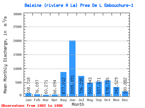
| Mean | 108.72 | 76.10 | 60.27 | 66.09 | 877.01 | 2005.09 | 736.24 | 500.94 | 537.37 | 578.74 | 342.53 | 180.88 | 507.73 |
| Standard Deviation | 29.31 | 22.88 | 20.07 | 57.81 | 663.84 | 740.52 | 241.40 | 225.82 | 227.91 | 195.47 | 129.27 | 57.63 | 74.38 |
| Min | 55.00 | 41.40 | 20.90 | 15.20 | 40.70 | 589.00 | 282.00 | 209.00 | 195.00 | 277.00 | 158.00 | 93.60 | 336.76 |
| Max | 187.00 | 125.00 | 104.00 | 374.00 | 3000.00 | 3630.00 | 1130.00 | 1110.00 | 1330.00 | 1140.00 | 638.00 | 334.00 | 653.06 |
| Coefficient of Variation | 0.27 | 0.30 | 0.33 | 0.88 | 0.76 | 0.37 | 0.33 | 0.45 | 0.42 | 0.34 | 0.38 | 0.32 | 0.15 |
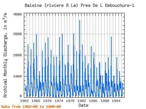
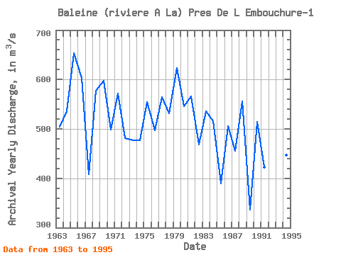
| Year | Jan | Feb | Mar | Apr | May | Jun | Jul | Aug | Sep | Oct | Nov | Dec | Annual | 1962 | 308.00 | 545.00 | 446.00 | 214.00 | 139.00 | 1963 | 86.80 | 65.70 | 54.30 | 80.20 | 294.00 | 2490.00 | 900.00 | 789.00 | 417.00 | 358.00 | 348.00 | 171.00 | 504.50 | 1964 | 108.00 | 77.60 | 65.30 | 69.10 | 704.00 | 2260.00 | 652.00 | 693.00 | 698.00 | 654.00 | 288.00 | 158.00 | 535.58 | 1965 | 95.10 | 72.90 | 62.30 | 57.40 | 622.00 | 2580.00 | 1120.00 | 863.00 | 1330.00 | 583.00 | 285.00 | 166.00 | 653.06 | 1966 | 118.00 | 91.70 | 74.50 | 82.50 | 493.00 | 2960.00 | 952.00 | 771.00 | 456.00 | 522.00 | 442.00 | 283.00 | 603.81 | 1967 | 132.00 | 49.10 | 20.90 | 15.20 | 843.00 | 1220.00 | 346.00 | 308.00 | 395.00 | 705.00 | 620.00 | 238.00 | 407.68 | 1968 | 149.00 | 115.00 | 90.10 | 72.80 | 1160.00 | 2200.00 | 648.00 | 657.00 | 376.00 | 708.00 | 549.00 | 209.00 | 577.83 | 1969 | 138.00 | 108.00 | 87.20 | 71.80 | 326.00 | 2570.00 | 1000.00 | 777.00 | 823.00 | 555.00 | 416.00 | 290.00 | 596.83 | 1970 | 187.00 | 111.00 | 75.00 | 59.10 | 166.00 | 2820.00 | 995.00 | 510.00 | 384.00 | 348.00 | 176.00 | 147.00 | 498.18 | 1971 | 107.00 | 80.10 | 64.80 | 68.20 | 930.00 | 2230.00 | 837.00 | 676.00 | 561.00 | 669.00 | 423.00 | 217.00 | 571.92 | 1972 | 146.00 | 101.00 | 71.60 | 51.20 | 40.70 | 1920.00 | 1130.00 | 558.00 | 844.00 | 571.00 | 218.00 | 124.00 | 481.29 | 1973 | 77.40 | 51.10 | 36.50 | 28.40 | 1910.00 | 879.00 | 610.00 | 365.00 | 326.00 | 572.00 | 638.00 | 238.00 | 477.62 | 1974 | 95.50 | 46.70 | 26.20 | 20.10 | 197.00 | 2830.00 | 597.00 | 317.00 | 340.00 | 732.00 | 304.00 | 220.00 | 477.12 | 1975 | 154.00 | 108.00 | 72.20 | 51.70 | 177.00 | 3000.00 | 935.00 | 844.00 | 408.00 | 330.00 | 354.00 | 213.00 | 553.91 | 1976 | 109.00 | 59.50 | 43.10 | 38.80 | 1540.00 | 1450.00 | 600.00 | 582.00 | 636.00 | 466.00 | 257.00 | 191.00 | 497.70 | 1977 | 151.00 | 125.00 | 104.00 | 87.90 | 840.00 | 2480.00 | 734.00 | 691.00 | 365.00 | 277.00 | 590.00 | 334.00 | 564.91 | 1978 | 106.00 | 48.80 | 29.50 | 22.70 | 740.00 | 1500.00 | 1100.00 | 1110.00 | 741.00 | 551.00 | 275.00 | 155.00 | 531.58 | 1979 | 106.00 | 84.20 | 74.00 | 71.70 | 3000.00 | 1920.00 | 586.00 | 262.00 | 368.00 | 541.00 | 299.00 | 175.00 | 623.91 | 1980 | 120.00 | 94.50 | 82.30 | 80.40 | 1560.00 | 2180.00 | 482.00 | 334.00 | 451.00 | 544.00 | 414.00 | 202.00 | 545.35 | 1981 | 138.00 | 111.00 | 98.00 | 93.10 | 450.00 | 3630.00 | 819.00 | 249.00 | 294.00 | 540.00 | 245.00 | 129.00 | 566.34 | 1982 | 90.60 | 74.20 | 66.30 | 64.00 | 325.00 | 2490.00 | 896.00 | 325.00 | 550.00 | 427.00 | 196.00 | 110.00 | 467.84 | 1983 | 75.70 | 58.30 | 51.10 | 374.00 | 1960.00 | 790.00 | 767.00 | 393.00 | 564.00 | 807.00 | 392.00 | 193.00 | 535.42 | 1984 | 115.00 | 80.00 | 63.10 | 59.50 | 1420.00 | 1600.00 | 575.00 | 499.00 | 558.00 | 678.00 | 356.00 | 178.00 | 515.13 | 1985 | 106.00 | 74.10 | 59.20 | 53.40 | 342.00 | 2420.00 | 475.00 | 288.00 | 195.00 | 305.00 | 234.00 | 132.00 | 390.31 | 1986 | 86.80 | 65.40 | 55.90 | 58.80 | 1550.00 | 2120.00 | 980.00 | 329.00 | 286.00 | 278.00 | 158.00 | 93.60 | 505.12 | 1987 | 64.20 | 52.20 | 49.80 | 67.50 | 1400.00 | 1050.00 | 558.00 | 821.00 | 689.00 | 406.00 | 213.00 | 94.40 | 455.43 | 1988 | 55.00 | 41.40 | 36.30 | 41.90 | 1510.00 | 1660.00 | 493.00 | 409.00 | 916.00 | 1020.00 | 334.00 | 158.00 | 556.22 | 1989 | 80.40 | 46.20 | 33.40 | 31.10 | 922.00 | 1030.00 | 354.00 | 209.00 | 280.00 | 626.00 | 285.00 | 144.00 | 336.76 | 1990 | 85.10 | 59.60 | 45.60 | 40.90 | 861.00 | 1650.00 | 622.00 | 346.00 | 805.00 | 1140.00 | 348.00 | 172.00 | 514.60 | 1991 | 103.00 | 69.40 | 51.20 | 42.00 | 134.00 | 1880.00 | 740.00 | 325.00 | 586.00 | 722.00 | 297.00 | 123.00 | 422.72 | 1992 | 79.40 | 64.20 | 59.60 | 57.60 | 89.70 | 2860.00 | 1110.00 | 496.00 | 635.00 | 758.00 | 304.00 | 141.00 | 554.54 | 1993 | 78.50 | 53.30 | 43.00 | 40.30 | 999.00 | 1020.00 | 282.00 | 266.00 | 602.00 | 637.00 | 222.00 | 130.00 | 364.43 | 1994 | 93.90 | 79.40 | 71.40 | 69.20 | 443.00 | 1890.00 | 745.00 | 355.00 | 594.00 | 446.00 | 372.00 | 207.00 | 447.16 | 1995 | 130.00 | 86.30 | 61.00 | 54.40 | 1220.00 | 589.00 | 437.00 | 354.00 | 501.00 | 755.00 | 580.00 | 275.00 | 420.23 | 1996 | 129.00 | 82.40 | 70.50 | 70.30 | 650.00 | 955.00 | 454.00 | 289.00 |
|---|
 Return to R-Arctic Net Home Page