|
|
|||||||||||||||||
| Point ID: 5181 | Downloads | Plots | Site Data | Code: 03MB002 |
|
|
|||||||||||||||||
| Download | |
|---|---|
| Site Descriptor Information | Site Time Series Data |
| Link to all available data | |
| View: | Time Series | All |
| Units: | mm |
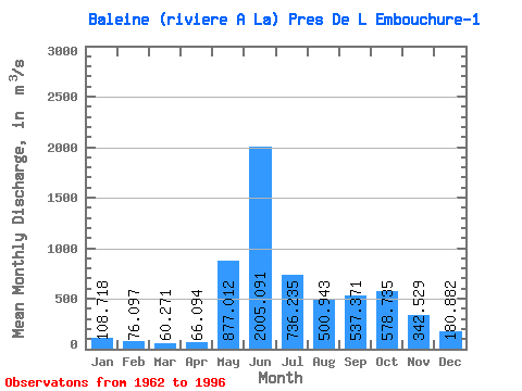
| Statistic | Jan | Feb | Mar | Apr | May | Jun | Jul | Aug | Sep | Oct | Nov | Dec | Annual |
|---|---|---|---|---|---|---|---|---|---|---|---|---|---|
| Mean | 108.72 | 76.10 | 60.27 | 66.09 | 877.01 | 2005.09 | 736.24 | 500.94 | 537.37 | 578.74 | 342.53 | 180.88 | 507.73 |
| Standard Deviation | 29.31 | 22.88 | 20.07 | 57.81 | 663.84 | 740.52 | 241.40 | 225.82 | 227.91 | 195.47 | 129.27 | 57.63 | 74.38 |
| Min | 55.00 | 41.40 | 20.90 | 15.20 | 40.70 | 589.00 | 282.00 | 209.00 | 195.00 | 277.00 | 158.00 | 93.60 | 336.76 |
| Max | 187.00 | 125.00 | 104.00 | 374.00 | 3000.00 | 3630.00 | 1130.00 | 1110.00 | 1330.00 | 1140.00 | 638.00 | 334.00 | 653.06 |
| Coefficient of Variation | 0.27 | 0.30 | 0.33 | 0.88 | 0.76 | 0.37 | 0.33 | 0.45 | 0.42 | 0.34 | 0.38 | 0.32 | 0.15 |
 Return to R-Arctic Net Home Page