|
|
|||||||||||||||||
| Point ID: 5178 | Downloads | Plots | Site Data | Code: 03LE002 |
|
|
|||||||||||||||||
| Download | |
|---|---|
| Site Descriptor Information | Site Time Series Data |
| Link to all available data | |
|
|
| View: | Statistics | Time Series |
| Units: | mm |
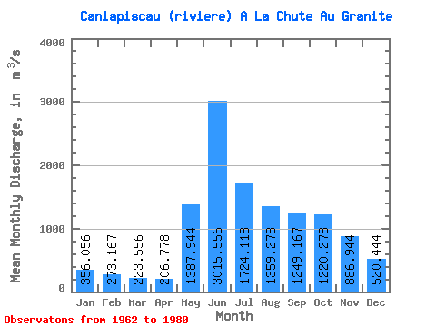
| Statistic | Jan | Feb | Mar | Apr | May | Jun | Jul | Aug | Sep | Oct | Nov | Dec | Annual |
|---|---|---|---|---|---|---|---|---|---|---|---|---|---|
| Mean | 356.06 | 273.17 | 223.56 | 206.78 | 1387.94 | 3015.56 | 1724.12 | 1359.28 | 1249.17 | 1220.28 | 886.94 | 520.44 | 1039.47 |
| Standard Deviation | 81.50 | 48.68 | 31.69 | 27.47 | 886.56 | 718.42 | 529.25 | 475.97 | 432.38 | 343.45 | 318.70 | 161.08 | 167.62 |
| Min | 245.00 | 198.00 | 171.00 | 160.00 | 220.00 | 1880.00 | 1150.00 | 689.00 | 720.00 | 590.00 | 479.00 | 323.00 | 830.83 |
| Max | 561.00 | 400.00 | 293.00 | 252.00 | 3740.00 | 4230.00 | 3070.00 | 2310.00 | 2340.00 | 1860.00 | 1430.00 | 842.00 | 1357.17 |
| Coefficient of Variation | 0.23 | 0.18 | 0.14 | 0.13 | 0.64 | 0.24 | 0.31 | 0.35 | 0.35 | 0.28 | 0.36 | 0.31 | 0.16 |
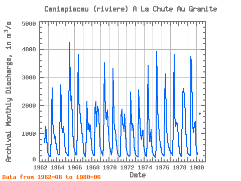
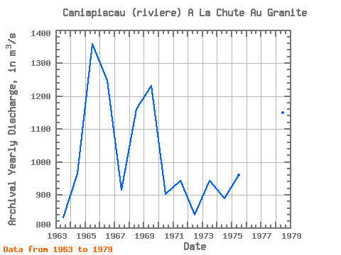
| Year | Jan | Feb | Mar | Apr | May | Jun | Jul | Aug | Sep | Oct | Nov | Dec | Annual | 1962 | 689.00 | 1240.00 | 1050.00 | 566.00 | 323.00 | 1963 | 249.00 | 219.00 | 195.00 | 189.00 | 1030.00 | 2630.00 | 1360.00 | 1130.00 | 814.00 | 881.00 | 736.00 | 537.00 | 830.83 | 1964 | 388.00 | 282.00 | 236.00 | 252.00 | 1800.00 | 2740.00 | 1320.00 | 1040.00 | 1090.00 | 1240.00 | 771.00 | 416.00 | 964.58 | 1965 | 339.00 | 287.00 | 242.00 | 205.00 | 797.00 | 4230.00 | 3070.00 | 2180.00 | 2340.00 | 1370.00 | 720.00 | 506.00 | 1357.17 | 1966 | 385.00 | 301.00 | 235.00 | 244.00 | 1260.00 | 3810.00 | 2050.00 | 1980.00 | 1460.00 | 1330.00 | 1050.00 | 842.00 | 1245.58 | 1967 | 467.00 | 306.00 | 211.00 | 167.00 | 856.00 | 2150.00 | 1150.00 | 1370.00 | 1060.00 | 1330.00 | 1220.00 | 697.00 | 915.33 | 1968 | 423.00 | 299.00 | 233.00 | 232.00 | 1860.00 | 2140.00 | 1250.00 | 1960.00 | 1890.00 | 1860.00 | 1200.00 | 563.00 | 1159.17 | 1969 | 408.00 | 329.00 | 270.00 | 213.00 | 573.00 | 3530.00 | 2340.00 | 1570.00 | 1500.00 | 1840.00 | 1390.00 | 820.00 | 1231.92 | 1970 | 561.00 | 400.00 | 293.00 | 234.00 | 537.00 | 3320.00 | 1530.00 | 1150.00 | 1120.00 | 838.00 | 497.00 | 335.00 | 901.25 | 1971 | 246.00 | 198.00 | 171.00 | 202.00 | 1620.00 | 1880.00 | 1310.00 | 1280.00 | 1070.00 | 1700.00 | 1110.00 | 522.00 | 942.42 | 1972 | 330.00 | 260.00 | 215.00 | 184.00 | 220.00 | 2490.00 | 1890.00 | 1120.00 | 1360.00 | 1150.00 | 545.00 | 325.00 | 840.75 | 1973 | 245.00 | 203.00 | 178.00 | 169.00 | 2560.00 | 2070.00 | 1370.00 | 982.00 | 780.00 | 1090.00 | 1100.00 | 582.00 | 944.08 | 1974 | 382.00 | 282.00 | 221.00 | 192.00 | 726.00 | 3440.00 | 1770.00 | 716.00 | 720.00 | 1150.00 | 676.00 | 384.00 | 888.25 | 1975 | 281.00 | 220.00 | 180.00 | 160.00 | 464.00 | 3940.00 | 1780.00 | 1580.00 | 1020.00 | 806.00 | 664.00 | 436.00 | 960.92 | 1976 | 314.00 | 251.00 | 219.00 | 207.00 | 2420.00 | 3130.00 | 1350.00 | 1120.00 | 731.00 | 590.00 | 479.00 | 405.00 | 934.67 | 1977 | 345.00 | 296.00 | 253.00 | 223.00 | 1320.00 | 3810.00 | 1600.00 | 1240.00 | 1400.00 | 1340.00 | 1180.00 | 669.00 | 1139.67 | 1978 | 384.00 | 259.00 | 204.00 | 189.00 | 1480.00 | 2470.00 | 2610.00 | 2310.00 | 1790.00 | 1070.00 | 631.00 | 388.00 | 1148.75 | 1979 | 296.00 | 251.00 | 227.00 | 225.00 | 3740.00 | 3360.00 | 1560.00 | 1050.00 | 1100.00 | 1330.00 | 1430.00 | 618.00 | 1265.58 | 1980 | 366.00 | 274.00 | 241.00 | 235.00 | 1720.00 | 3140.00 |
|---|
 Return to R-Arctic Net Home Page