|
|
|||||||||||||||||
| Point ID: 5159 | Downloads | Plots | Site Data | Code: 03HA001 |
|
|
|||||||||||||||||
| Download | |
|---|---|
| Site Descriptor Information | Site Time Series Data |
| Link to all available data | |
|
|
| View: | Statistics | Time Series |
| Units: | mm |
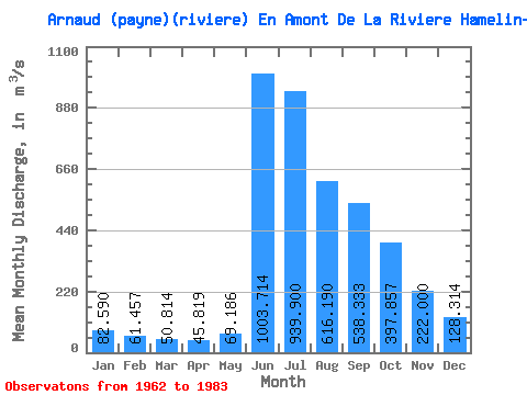
| Statistic | Jan | Feb | Mar | Apr | May | Jun | Jul | Aug | Sep | Oct | Nov | Dec | Annual |
|---|---|---|---|---|---|---|---|---|---|---|---|---|---|
| Mean | 82.59 | 61.46 | 50.81 | 45.82 | 69.19 | 1003.71 | 939.90 | 616.19 | 538.33 | 397.86 | 222.00 | 128.31 | 345.12 |
| Standard Deviation | 21.34 | 13.40 | 9.42 | 7.05 | 43.38 | 339.12 | 237.95 | 151.24 | 144.32 | 104.30 | 49.52 | 38.45 | 61.84 |
| Min | 52.00 | 46.10 | 38.70 | 33.70 | 33.40 | 366.00 | 567.00 | 405.00 | 341.00 | 246.00 | 134.00 | 72.40 | 208.16 |
| Max | 134.00 | 101.00 | 77.00 | 59.20 | 241.00 | 1630.00 | 1440.00 | 1060.00 | 873.00 | 607.00 | 306.00 | 243.00 | 513.77 |
| Coefficient of Variation | 0.26 | 0.22 | 0.18 | 0.15 | 0.63 | 0.34 | 0.25 | 0.24 | 0.27 | 0.26 | 0.22 | 0.30 | 0.18 |
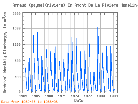
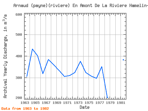
| Year | Jan | Feb | Mar | Apr | May | Jun | Jul | Aug | Sep | Oct | Nov | Dec | Annual | 1962 | 622.00 | 589.00 | 430.00 | 224.00 | 138.00 | 1963 | 75.00 | 59.50 | 53.10 | 56.00 | 65.00 | 735.00 | 847.00 | 566.00 | 525.00 | 373.00 | 199.00 | 109.00 | 305.22 | 1964 | 66.00 | 47.20 | 40.20 | 40.40 | 42.10 | 833.00 | 1440.00 | 852.00 | 867.00 | 592.00 | 257.00 | 126.00 | 433.57 | 1965 | 88.00 | 73.90 | 64.50 | 59.20 | 78.20 | 1500.00 | 999.00 | 716.00 | 602.00 | 359.00 | 173.00 | 108.00 | 401.73 | 1966 | 75.90 | 58.40 | 46.50 | 38.00 | 59.00 | 910.00 | 784.00 | 475.00 | 416.00 | 413.00 | 295.00 | 243.00 | 317.82 | 1967 | 134.00 | 64.50 | 45.20 | 41.70 | 77.20 | 1100.00 | 1050.00 | 701.00 | 575.00 | 390.00 | 239.00 | 189.00 | 383.88 | 1968 | 105.00 | 68.90 | 57.40 | 54.50 | 78.70 | 1020.00 | 850.00 | 672.00 | 462.00 | 463.00 | 306.00 | 179.00 | 359.71 | 1969 | 125.00 | 101.00 | 77.00 | 53.60 | 59.30 | 933.00 | 1140.00 | 566.00 | 397.00 | 266.00 | 168.00 | 117.00 | 333.57 | 1970 | 77.10 | 52.00 | 38.70 | 33.70 | 33.40 | 633.00 | 784.00 | 620.00 | 540.00 | 478.00 | 248.00 | 119.00 | 304.74 | 1971 | 77.00 | 62.20 | 55.00 | 50.40 | 52.20 | 538.00 | 839.00 | 616.00 | 610.00 | 463.00 | 249.00 | 98.70 | 309.21 | 1972 | 63.70 | 52.10 | 47.60 | 45.90 | 44.60 | 370.00 | 1200.00 | 777.00 | 684.00 | 391.00 | 146.00 | 72.40 | 324.52 | 1973 | 52.00 | 46.10 | 43.40 | 41.80 | 241.00 | 1370.00 | 925.00 | 504.00 | 505.00 | 401.00 | 244.00 | 132.00 | 375.44 | 1974 | 88.20 | 61.70 | 44.70 | 36.80 | 65.80 | 1350.00 | 624.00 | 405.00 | 489.00 | 336.00 | 225.00 | 158.00 | 323.68 | 1975 | 113.00 | 85.60 | 66.30 | 55.60 | 82.10 | 1020.00 | 759.00 | 441.00 | 363.00 | 336.00 | 230.00 | 138.00 | 307.47 | 1976 | 99.10 | 75.30 | 56.70 | 44.50 | 108.00 | 1040.00 | 725.00 | 512.00 | 427.00 | 255.00 | 134.00 | 88.90 | 297.12 | 1977 | 67.60 | 57.60 | 51.50 | 48.90 | 68.60 | 1220.00 | 1140.00 | 641.00 | 389.00 | 246.00 | 184.00 | 93.90 | 350.68 | 1978 | 60.20 | 48.80 | 46.10 | 45.90 | 49.20 | 366.00 | 567.00 | 463.00 | 341.00 | 251.00 | 160.00 | 99.70 | 208.16 | 1979 | 71.50 | 57.50 | 49.10 | 44.10 | 48.00 | 1630.00 | 1330.00 | 1060.00 | 873.00 | 607.00 | 273.00 | 122.00 | 513.77 | 1980 | 71.20 | 51.70 | 44.20 | 42.20 | 46.50 | 1090.00 | 698.00 | 513.00 | 643.00 | 415.00 | 199.00 | 111.00 | 327.07 | 1981 | 71.00 | 53.30 | 43.70 | 38.50 | 39.10 | 1070.00 | 1180.00 | 618.00 | 501.00 | 552.00 | 295.00 | 135.00 | 383.05 | 1982 | 78.00 | 55.50 | 45.30 | 41.60 | 41.20 | 1150.00 | 917.00 | 600.00 | 507.00 | 338.00 | 214.00 | 117.00 | 342.05 | 1983 | 75.90 | 57.80 | 50.90 | 48.90 | 73.70 | 1200.00 |
|---|
 Return to R-Arctic Net Home Page