|
|
|||||||||||||||||
| Point ID: 5151 | Downloads | Plots | Site Data | Other Close Sites | Code: 03FC003 |
|
|
|||||||||||||||||
| Download | |
|---|---|
| Site Descriptor Information | Site Time Series Data |
| Link to all available data | |
|
|
| View: | Statistics | Time Series |
| Units: | mm |
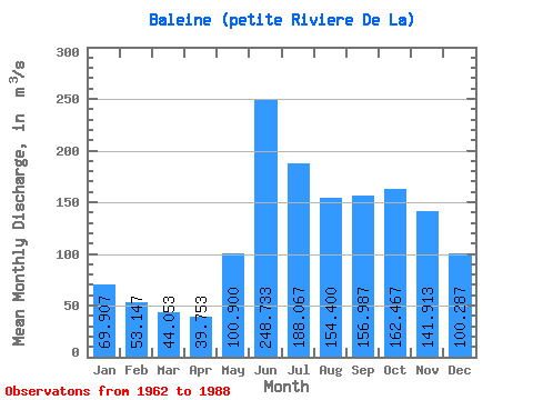
| Statistic | Jan | Feb | Mar | Apr | May | Jun | Jul | Aug | Sep | Oct | Nov | Dec | Annual |
|---|---|---|---|---|---|---|---|---|---|---|---|---|---|
| Mean | 69.91 | 53.15 | 44.05 | 39.75 | 100.90 | 248.73 | 188.07 | 154.40 | 156.99 | 162.47 | 141.91 | 100.29 | 122.75 |
| Standard Deviation | 11.22 | 8.80 | 7.06 | 6.33 | 36.26 | 38.06 | 26.86 | 36.00 | 45.17 | 38.04 | 24.95 | 16.15 | 11.26 |
| Min | 60.20 | 47.00 | 37.70 | 30.70 | 54.50 | 173.00 | 129.00 | 112.00 | 90.80 | 119.00 | 91.70 | 72.50 | 105.44 |
| Max | 103.00 | 79.50 | 63.10 | 55.90 | 161.00 | 336.00 | 230.00 | 259.00 | 241.00 | 252.00 | 184.00 | 137.00 | 147.12 |
| Coefficient of Variation | 0.16 | 0.17 | 0.16 | 0.16 | 0.36 | 0.15 | 0.14 | 0.23 | 0.29 | 0.23 | 0.18 | 0.16 | 0.09 |
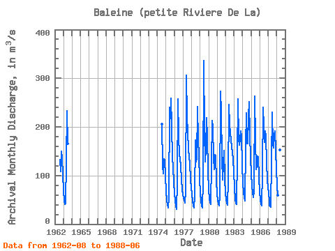
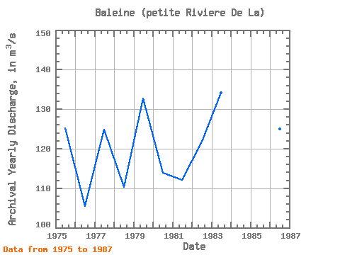
| Year | Jan | Feb | Mar | Apr | May | Jun | Jul | Aug | Sep | Oct | Nov | Dec | Annual | 1962 | 133.00 | 108.00 | 150.00 | 135.00 | 103.00 | 1963 | 68.50 | 47.60 | 41.20 | 41.70 | 128.00 | 233.00 | 166.00 | 1974 | 206.00 | 120.00 | 104.00 | 134.00 | 133.00 | 97.50 | 1975 | 67.90 | 48.90 | 39.50 | 34.00 | 54.50 | 240.00 | 217.00 | 259.00 | 202.00 | 136.00 | 118.00 | 85.60 | 125.20 | 1976 | 62.70 | 47.70 | 37.70 | 30.70 | 85.30 | 258.00 | 181.00 | 143.00 | 136.00 | 119.00 | 91.70 | 72.50 | 105.44 | 1977 | 60.20 | 53.10 | 49.40 | 44.20 | 68.70 | 306.00 | 221.00 | 187.00 | 156.00 | 136.00 | 127.00 | 90.30 | 124.91 | 1978 | 61.50 | 47.00 | 38.70 | 33.50 | 57.90 | 173.00 | 129.00 | 134.00 | 241.00 | 174.00 | 140.00 | 93.00 | 110.22 | 1979 | 63.50 | 47.30 | 38.10 | 34.40 | 88.70 | 336.00 | 192.00 | 128.00 | 156.00 | 219.00 | 180.00 | 110.00 | 132.75 | 1980 | 71.10 | 53.00 | 44.40 | 41.20 | 124.00 | 213.00 | 199.00 | 137.00 | 113.00 | 142.00 | 140.00 | 90.00 | 113.97 | 1981 | 62.30 | 48.90 | 41.90 | 38.60 | 57.50 | 273.00 | 230.00 | 135.00 | 90.80 | 123.00 | 151.00 | 93.70 | 112.14 | 1982 | 63.70 | 50.70 | 43.60 | 39.80 | 91.70 | 246.00 | 204.00 | 173.00 | 159.00 | 149.00 | 131.00 | 110.00 | 121.79 | 1983 | 73.20 | 51.70 | 42.20 | 40.50 | 138.00 | 258.00 | 174.00 | 163.00 | 174.00 | 192.00 | 181.00 | 123.00 | 134.22 | 1984 | 83.50 | 65.00 | 54.60 | 48.30 | 161.00 | 228.00 | 166.00 | 166.00 | 220.00 | 252.00 | 184.00 | 137.00 | 147.12 | 1985 | 103.00 | 79.50 | 63.10 | 55.90 | 67.20 | 263.00 | 173.00 | 112.00 | 120.00 | 140.00 | 139.00 | 96.20 | 117.66 | 1986 | 66.70 | 50.20 | 40.90 | 38.50 | 108.00 | 240.00 | 200.00 | 169.00 | 191.00 | 180.00 | 127.00 | 89.50 | 125.07 | 1987 | 63.30 | 47.60 | 38.30 | 35.80 | 130.00 | 230.00 | 163.00 | 157.00 | 184.00 | 191.00 | 151.00 | 113.00 | 125.33 | 1988 | 77.50 | 59.00 | 47.20 | 39.20 | 153.00 | 234.00 |
|---|
| Other Close Sites | ||||||
|---|---|---|---|---|---|---|
| PointID | Latitude | Longitude | Drainage Area | Source | Name | |
| 5153 | "BOUTIN (RIVIERE) A LA SORTIE DES LACS MOLLET-1" | 55.57 | -1006550 | Hydat | ||
| 5154 | "BOUTIN (RIVIERE) A LA SORTIE DES LAC MOLLET-2" | 55.57 | -1006550 | Hydat | ||
| 5155 | "BALEINE (PETITE RIVIERE DE LA) EN AMONT DU CHENAL ANCEL" | 55.68 | -1015440 | Hydat | ||
 Return to R-Arctic Net Home Page