|
|
|||||||||||||||||
| Point ID: 5151 | Downloads | Plots | Site Data | Other Close Sites | Code: 03FC003 |
|
|
|||||||||||||||||
| Download | |
|---|---|
| Site Descriptor Information | Site Time Series Data |
| Link to all available data | |
| View: | Time Series | All |
| Units: | mm |
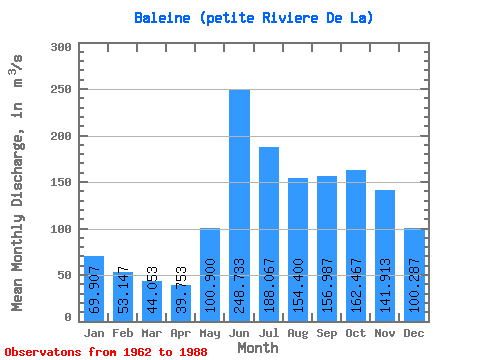
| Statistic | Jan | Feb | Mar | Apr | May | Jun | Jul | Aug | Sep | Oct | Nov | Dec | Annual |
|---|---|---|---|---|---|---|---|---|---|---|---|---|---|
| Mean | 69.91 | 53.15 | 44.05 | 39.75 | 100.90 | 248.73 | 188.07 | 154.40 | 156.99 | 162.47 | 141.91 | 100.29 | 122.75 |
| Standard Deviation | 11.22 | 8.80 | 7.06 | 6.33 | 36.26 | 38.06 | 26.86 | 36.00 | 45.17 | 38.04 | 24.95 | 16.15 | 11.26 |
| Min | 60.20 | 47.00 | 37.70 | 30.70 | 54.50 | 173.00 | 129.00 | 112.00 | 90.80 | 119.00 | 91.70 | 72.50 | 105.44 |
| Max | 103.00 | 79.50 | 63.10 | 55.90 | 161.00 | 336.00 | 230.00 | 259.00 | 241.00 | 252.00 | 184.00 | 137.00 | 147.12 |
| Coefficient of Variation | 0.16 | 0.17 | 0.16 | 0.16 | 0.36 | 0.15 | 0.14 | 0.23 | 0.29 | 0.23 | 0.18 | 0.16 | 0.09 |
| Other Close Sites | ||||||
|---|---|---|---|---|---|---|
| PointID | Latitude | Longitude | Drainage Area | Source | Name | |
| 5153 | "BOUTIN (RIVIERE) A LA SORTIE DES LACS MOLLET-1" | 55.57 | -1006550 | Hydat | ||
| 5154 | "BOUTIN (RIVIERE) A LA SORTIE DES LAC MOLLET-2" | 55.57 | -1006550 | Hydat | ||
| 5155 | "BALEINE (PETITE RIVIERE DE LA) EN AMONT DU CHENAL ANCEL" | 55.68 | -1015440 | Hydat | ||
 Return to R-Arctic Net Home Page