|
|
|||||||||||||||||
| Point ID: 5137 | Downloads | Plots | Site Data | Other Close Sites | Code: 03ED001 |
|
|
|||||||||||||||||
| Download | |
|---|---|
| Site Descriptor Information | Site Time Series Data |
| Link to all available data | |
|
|
| View: | Statistics | Time Series |
| Units: | mm |
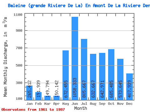
| Statistic | Jan | Feb | Mar | Apr | May | Jun | Jul | Aug | Sep | Oct | Nov | Dec | Annual |
|---|---|---|---|---|---|---|---|---|---|---|---|---|---|
| Mean | 265.41 | 191.94 | 149.79 | 150.14 | 672.46 | 1058.33 | 805.67 | 632.67 | 642.97 | 685.49 | 573.64 | 407.94 | 523.61 |
| Standard Deviation | 36.33 | 28.36 | 23.95 | 54.58 | 187.86 | 269.01 | 209.65 | 185.29 | 170.51 | 145.15 | 109.52 | 71.58 | 63.26 |
| Min | 197.00 | 147.00 | 109.00 | 92.70 | 336.00 | 573.00 | 483.00 | 311.00 | 315.00 | 450.00 | 375.00 | 268.00 | 375.00 |
| Max | 329.00 | 255.00 | 209.00 | 368.00 | 1000.00 | 1570.00 | 1560.00 | 1110.00 | 969.00 | 977.00 | 887.00 | 568.00 | 686.33 |
| Coefficient of Variation | 0.14 | 0.15 | 0.16 | 0.36 | 0.28 | 0.25 | 0.26 | 0.29 | 0.27 | 0.21 | 0.19 | 0.17 | 0.12 |
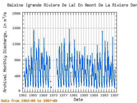
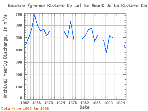
| Year | Jan | Feb | Mar | Apr | May | Jun | Jul | Aug | Sep | Oct | Nov | Dec | Annual | 1961 | 376.00 | 509.00 | 499.00 | 365.00 | 1962 | 231.00 | 166.00 | 137.00 | 126.00 | 562.00 | 842.00 | 794.00 | 465.00 | 496.00 | 579.00 | 508.00 | 391.00 | 441.42 | 1963 | 220.00 | 153.00 | 123.00 | 164.00 | 690.00 | 897.00 | 706.00 | 643.00 | 662.00 | 615.00 | 535.00 | 568.00 | 498.00 | 1964 | 285.00 | 201.00 | 171.00 | 368.00 | 859.00 | 1110.00 | 705.00 | 451.00 | 663.00 | 856.00 | 718.00 | 506.00 | 574.42 | 1965 | 292.00 | 204.00 | 154.00 | 123.00 | 779.00 | 1480.00 | 1560.00 | 966.00 | 802.00 | 804.00 | 625.00 | 447.00 | 686.33 | 1966 | 257.00 | 160.00 | 128.00 | 169.00 | 535.00 | 1110.00 | 1020.00 | 981.00 | 820.00 | 850.00 | 656.00 | 475.00 | 596.75 | 1967 | 297.00 | 189.00 | 126.00 | 105.00 | 1000.00 | 1320.00 | 865.00 | 684.00 | 541.00 | 532.00 | 539.00 | 441.00 | 553.25 | 1968 | 267.00 | 185.00 | 148.00 | 172.00 | 979.00 | 941.00 | 581.00 | 600.00 | 794.00 | 977.00 | 780.00 | 439.00 | 571.92 | 1969 | 287.00 | 213.00 | 157.00 | 118.00 | 336.00 | 1350.00 | 846.00 | 557.00 | 546.00 | 673.00 | 658.00 | 452.00 | 516.08 | 1970 | 329.00 | 255.00 | 209.00 | 186.00 | 473.00 | 1010.00 | 845.00 | 702.00 | 892.00 | 833.00 | 522.00 | 340.00 | 549.67 | 1971 | 220.00 | 147.00 | 111.00 | 145.00 | 500.00 | 594.00 | 723.00 | 900.00 | 854.00 | 817.00 | 602.00 | 1972 | 264.00 | 127.00 | 109.00 | 1974 | 819.00 | 438.00 | 459.00 | 531.00 | 542.00 | 353.00 | 1975 | 235.00 | 176.00 | 144.00 | 116.00 | 591.00 | 1010.00 | 1140.00 | 1110.00 | 819.00 | 556.00 | 388.00 | 268.00 | 546.08 | 1976 | 200.00 | 160.00 | 134.00 | 123.00 | 788.00 | 1220.00 | 811.00 | 590.00 | 589.00 | 591.00 | 472.00 | 365.00 | 503.58 | 1977 | 266.00 | 210.00 | 181.00 | 166.00 | 984.00 | 1340.00 | 1110.00 | 944.00 | 708.00 | 543.00 | 646.00 | 502.00 | 633.33 | 1978 | 318.00 | 218.00 | 151.00 | 121.00 | 467.00 | 670.00 | 539.00 | 785.00 | 969.00 | 771.00 | 538.00 | 329.00 | 489.67 | 1979 | 247.00 | 186.00 | 145.00 | 124.00 | 782.00 | 1570.00 | 932.00 | 612.00 | 780.00 | 859.00 | 482.00 | 1980 | 301.00 | 215.00 | 180.00 | 776.00 | 954.00 | 815.00 | 620.00 | 602.00 | 670.00 | 561.00 | 413.00 | 1981 | 306.00 | 247.00 | 207.00 | 174.00 | 467.00 | 1310.00 | 898.00 | 537.00 | 376.00 | 466.00 | 525.00 | 426.00 | 494.92 | 1982 | 295.00 | 236.00 | 162.00 | 120.00 | 585.00 | 1030.00 | 941.00 | 699.00 | 586.00 | 561.00 | 511.00 | 456.00 | 515.17 | 1983 | 296.00 | 204.00 | 148.00 | 132.00 | 856.00 | 1010.00 | 726.00 | 706.00 | 718.00 | 833.00 | 706.00 | 453.00 | 565.67 | 1984 | 293.00 | 211.00 | 170.00 | 278.00 | 898.00 | 931.00 | 696.00 | 559.00 | 803.00 | 895.00 | 646.00 | 518.00 | 574.83 | 1985 | 329.00 | 235.00 | 181.00 | 164.00 | 578.00 | 1130.00 | 646.00 | 452.00 | 482.00 | 552.00 | 526.00 | 377.00 | 471.00 | 1986 | 246.00 | 176.00 | 148.00 | 147.00 | 769.00 | 917.00 | 888.00 | 696.00 | 817.00 | 649.00 | 462.00 | 316.00 | 519.25 | 1987 | 230.00 | 170.00 | 129.00 | 224.00 | 804.00 | 776.00 | 652.00 | 667.00 | 914.00 | 737.00 | 416.00 | 1988 | 283.00 | 207.00 | 155.00 | 195.00 | 969.00 | 842.00 | 582.00 | 426.00 | 396.00 | 692.00 | 593.00 | 408.00 | 479.00 | 1989 | 276.00 | 192.00 | 139.00 | 119.00 | 573.00 | 828.00 | 514.00 | 311.00 | 315.00 | 462.00 | 446.00 | 325.00 | 375.00 | 1990 | 206.00 | 147.00 | 109.00 | 92.70 | 730.00 | 1170.00 | 789.00 | 558.00 | 667.00 | 737.00 | 604.00 | 392.00 | 516.81 | 1991 | 250.00 | 179.00 | 146.00 | 125.00 | 675.00 | 986.00 | 745.00 | 572.00 | 658.00 | 759.00 | 566.00 | 360.00 | 501.75 | 1992 | 247.00 | 181.00 | 142.00 | 114.00 | 384.00 | 1510.00 | 381.00 | 1993 | 254.00 | 183.00 | 141.00 | 120.00 | 708.00 | 1280.00 | 959.00 | 620.00 | 509.00 | 652.00 | 495.00 | 323.00 | 520.33 | 1994 | 226.00 | 171.00 | 137.00 | 116.00 | 435.00 | 1250.00 | 803.00 | 550.00 | 563.00 | 864.00 | 887.00 | 488.00 | 540.83 | 1995 | 299.00 | 205.00 | 170.00 | 134.00 | 680.00 | 594.00 | 483.00 | 318.00 | 495.00 | 746.00 | 652.00 | 409.00 | 432.08 | 1996 | 275.00 | 200.00 | 162.00 | 152.00 | 431.00 | 1370.00 | 860.00 | 550.00 | 542.00 | 450.00 | 375.00 | 278.00 | 470.42 | 1997 | 197.00 | 152.00 | 121.00 | 113.00 | 548.00 | 573.00 | 594.00 | 609.00 | 648.00 |
|---|
| Other Close Sites | ||||||
|---|---|---|---|---|---|---|
| PointID | Latitude | Longitude | Drainage Area | Source | Name | |
| 5139 | "BALEINE (GRANDE RIVIERE DE LA) EN AMONT DE LA RIVIERE DENYS" | 55.22 | -852168 | Hydat | ||
 Return to R-Arctic Net Home Page