|
|
|||||||||||||||||
| Point ID: 5123 | Downloads | Plots | Site Data | Other Close Sites | Code: 03DD003 |
|
|
|||||||||||||||||
| Download | |
|---|---|
| Site Descriptor Information | Site Time Series Data |
| Link to all available data | |
|
|
| View: | Statistics | Time Series |
| Units: | mm |
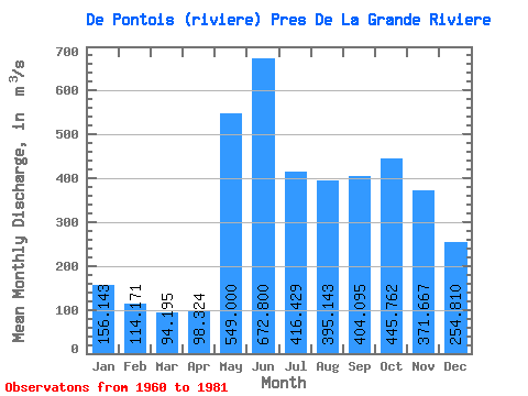
| Statistic | Jan | Feb | Mar | Apr | May | Jun | Jul | Aug | Sep | Oct | Nov | Dec | Annual |
|---|---|---|---|---|---|---|---|---|---|---|---|---|---|
| Mean | 156.14 | 114.17 | 94.19 | 98.32 | 549.00 | 672.80 | 416.43 | 395.14 | 404.10 | 445.76 | 371.67 | 254.81 | 330.75 |
| Standard Deviation | 29.77 | 19.70 | 17.36 | 23.50 | 193.13 | 160.69 | 108.51 | 139.61 | 120.66 | 131.25 | 97.87 | 62.60 | 50.20 |
| Min | 107.00 | 82.10 | 69.40 | 65.20 | 292.00 | 354.00 | 252.00 | 212.00 | 199.00 | 248.00 | 227.00 | 160.00 | 237.97 |
| Max | 239.00 | 173.00 | 141.00 | 156.00 | 1030.00 | 968.00 | 682.00 | 656.00 | 621.00 | 668.00 | 653.00 | 393.00 | 440.96 |
| Coefficient of Variation | 0.19 | 0.17 | 0.18 | 0.24 | 0.35 | 0.24 | 0.26 | 0.35 | 0.30 | 0.29 | 0.26 | 0.25 | 0.15 |
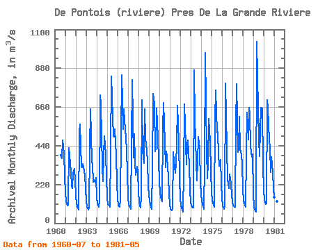
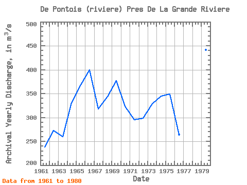
| Year | Jan | Feb | Mar | Apr | May | Jun | Jul | Aug | Sep | Oct | Nov | Dec | Annual | 1960 | 389.00 | 377.00 | 367.00 | 472.00 | 395.00 | 265.00 | 1961 | 176.00 | 126.00 | 99.60 | 106.00 | 426.00 | 386.00 | 288.00 | 212.00 | 199.00 | 285.00 | 309.00 | 243.00 | 237.97 | 1962 | 156.00 | 112.00 | 86.30 | 78.00 | 514.00 | 560.00 | 321.00 | 318.00 | 337.00 | 319.00 | 274.00 | 199.00 | 272.86 | 1963 | 125.00 | 95.40 | 77.60 | 89.80 | 425.00 | 647.00 | 354.00 | 329.00 | 236.00 | 248.00 | 229.00 | 260.00 | 259.65 | 1964 | 146.00 | 109.00 | 92.10 | 127.00 | 726.00 | 678.00 | 321.00 | 237.00 | 390.00 | 494.00 | 391.00 | 261.00 | 331.01 | 1965 | 142.00 | 109.00 | 99.20 | 93.40 | 408.00 | 832.00 | 597.00 | 495.00 | 491.00 | 535.00 | 383.00 | 229.00 | 367.80 | 1966 | 138.00 | 102.00 | 91.60 | 135.00 | 492.00 | 840.00 | 534.00 | 649.00 | 576.00 | 539.00 | 418.00 | 283.00 | 399.80 | 1967 | 149.00 | 106.00 | 87.80 | 81.50 | 462.00 | 816.00 | 373.00 | 506.00 | 350.00 | 273.00 | 322.00 | 291.00 | 318.11 | 1968 | 178.00 | 116.00 | 88.20 | 156.00 | 699.00 | 411.00 | 341.00 | 648.00 | 479.00 | 452.00 | 356.00 | 204.00 | 344.02 | 1969 | 165.00 | 124.00 | 94.10 | 81.50 | 315.00 | 737.00 | 682.00 | 408.00 | 425.00 | 651.00 | 485.00 | 354.00 | 376.80 | 1970 | 239.00 | 173.00 | 131.00 | 125.00 | 536.00 | 684.00 | 459.00 | 318.00 | 410.00 | 378.00 | 263.00 | 162.00 | 323.17 | 1971 | 107.00 | 82.10 | 72.70 | 83.10 | 403.00 | 354.00 | 287.00 | 346.00 | 440.00 | 668.00 | 460.00 | 245.00 | 295.66 | 1972 | 142.00 | 102.00 | 77.90 | 66.10 | 292.00 | 678.00 | 444.00 | 332.00 | 452.00 | 472.00 | 335.00 | 188.00 | 298.42 | 1973 | 120.00 | 98.60 | 87.20 | 88.10 | 868.00 | 597.00 | 346.00 | 242.00 | 354.00 | 489.00 | 425.00 | 232.00 | 328.91 | 1974 | 162.00 | 126.00 | 94.90 | 81.30 | 338.00 | 968.00 | 412.00 | 256.00 | 342.00 | 594.00 | 462.00 | 294.00 | 344.18 | 1975 | 177.00 | 130.00 | 105.00 | 90.90 | 593.00 | 755.00 | 514.00 | 518.00 | 388.00 | 324.00 | 361.00 | 229.00 | 348.74 | 1976 | 141.00 | 99.60 | 79.20 | 101.00 | 795.00 | 608.00 | 252.00 | 223.00 | 201.00 | 277.00 | 227.00 | 160.00 | 263.65 | 1977 | 122.00 | 102.00 | 92.30 | 91.10 | 556.00 | 791.00 | 404.00 | 418.00 | 606.00 | 419.00 | 389.00 | 334.00 | 360.37 | 1978 | 190.00 | 130.00 | 103.00 | 90.80 | 391.00 | 627.00 | 476.00 | 656.00 | 621.00 | 437.00 | 377.00 | 393.00 | 374.32 | 1979 | 164.00 | 92.90 | 69.40 | 65.20 | 1030.00 | 835.00 | 481.00 | 381.00 | 532.00 | 657.00 | 653.00 | 331.00 | 440.96 | 1980 | 191.00 | 131.00 | 108.00 | 111.00 | 698.00 | 652.00 | 470.00 | 429.00 | 290.00 | 378.00 | 291.00 | 194.00 | 328.58 | 1981 | 149.00 | 131.00 | 141.00 | 123.00 | 562.00 |
|---|
| Other Close Sites | ||||||
|---|---|---|---|---|---|---|
| PointID | Latitude | Longitude | Drainage Area | Source | Name | |
| 5117 | "GRANDE RIVIERE (LA) EN AMONT DE LA RIVIERE DE PONTOIS" | 53.62 | -1061683 | Hydat | ||
 Return to R-Arctic Net Home Page