|
|
|||||||||||||||||
| Point ID: 5120 | Downloads | Plots | Site Data | Code: 03DC005 |
|
|
|||||||||||||||||
| Download | |
|---|---|
| Site Descriptor Information | Site Time Series Data |
| Link to all available data | |
|
|
| View: | Statistics | Time Series |
| Units: | mm |
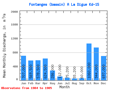
| Statistic | Jan | Feb | Mar | Apr | May | Jun | Jul | Aug | Sep | Oct | Nov | Dec | Annual |
|---|---|---|---|---|---|---|---|---|---|---|---|---|---|
| Mean | 707.00 | 569.50 | 578.50 | 624.50 | 286.00 | 112.00 | 75.20 | 55.20 | 60.00 | 1060.00 | 944.00 | 697.00 | |
| Standard Deviation | 159.10 | 101.12 | 601.75 | 115.97 | |||||||||
| Min | 707.00 | 457.00 | 507.00 | 199.00 | 204.00 | 112.00 | 75.20 | 55.20 | 60.00 | 1060.00 | 944.00 | 697.00 | |
| Max | 707.00 | 682.00 | 650.00 | 1050.00 | 368.00 | 112.00 | 75.20 | 55.20 | 60.00 | 1060.00 | 944.00 | 697.00 | |
| Coefficient of Variation | 0.28 | 0.17 | 0.96 | 0.41 |
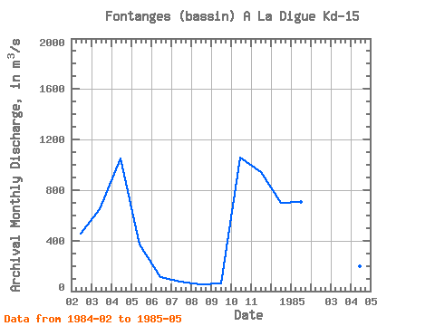
| Year | Jan | Feb | Mar | Apr | May | Jun | Jul | Aug | Sep | Oct | Nov | Dec | Annual | 1984 | 457.00 | 650.00 | 1050.00 | 368.00 | 112.00 | 75.20 | 55.20 | 60.00 | 1060.00 | 944.00 | 697.00 | 1985 | 707.00 | 682.00 | 507.00 | 199.00 | 204.00 |
|---|
 Return to R-Arctic Net Home Page