|
|
|||||||||||||||||
| Point ID: 5120 | Downloads | Plots | Site Data | Code: 03DC005 |
|
|
|||||||||||||||||
| Download | |
|---|---|
| Site Descriptor Information | Site Time Series Data |
| Link to all available data | |
|
|
| View: | Statistics | Time Series |
| Units: | m3/s |
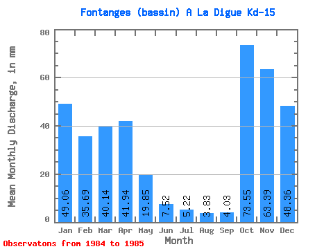
| Statistic | Jan | Feb | Mar | Apr | May | Jun | Jul | Aug | Sep | Oct | Nov | Dec | Annual |
|---|---|---|---|---|---|---|---|---|---|---|---|---|---|
| Mean | 49.05 | 36.00 | 40.13 | 41.94 | 19.84 | 7.52 | 5.22 | 3.83 | 4.03 | 73.54 | 63.39 | 48.36 | |
| Standard Deviation | 10.06 | 7.01 | 40.41 | 8.04 | |||||||||
| Min | 49.05 | 28.89 | 35.17 | 13.36 | 14.15 | 7.52 | 5.22 | 3.83 | 4.03 | 73.54 | 63.39 | 48.36 | |
| Max | 49.05 | 43.11 | 45.10 | 70.51 | 25.53 | 7.52 | 5.22 | 3.83 | 4.03 | 73.54 | 63.39 | 48.36 | |
| Coefficient of Variation | 0.28 | 0.17 | 0.96 | 0.41 |
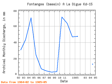
| Year | Jan | Feb | Mar | Apr | May | Jun | Jul | Aug | Sep | Oct | Nov | Dec | Annual | 1984 | 28.89 | 45.10 | 70.51 | 25.53 | 7.52 | 5.22 | 3.83 | 4.03 | 73.54 | 63.39 | 48.36 | 1985 | 49.05 | 43.11 | 35.17 | 13.36 | 14.15 |
|---|
 Return to R-Arctic Net Home Page