|
|
|||||||||||||||||
| Point ID: 5119 | Downloads | Plots | Site Data | Code: 03DC004 |
|
|
|||||||||||||||||
| Download | |
|---|---|
| Site Descriptor Information | Site Time Series Data |
| Link to all available data | |
|
|
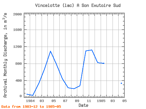
| View: | Statistics | Time Series |
| Units: | mm |
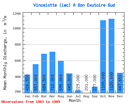
| Statistic | Jan | Feb | Mar | Apr | May | Jun | Jul | Aug | Sep | Oct | Nov | Dec | Annual |
|---|---|---|---|---|---|---|---|---|---|---|---|---|---|
| Mean | 426.55 | 557.00 | 684.50 | 712.00 | 595.00 | 443.00 | 229.00 | 201.00 | 277.00 | 1100.00 | 1120.00 | 447.65 | 591.26 |
| Standard Deviation | 542.28 | 339.41 | 33.23 | 534.57 | 277.19 | 530.83 | |||||||
| Min | 43.10 | 317.00 | 661.00 | 334.00 | 399.00 | 443.00 | 229.00 | 201.00 | 277.00 | 1100.00 | 1120.00 | 72.30 | 591.26 |
| Max | 810.00 | 797.00 | 708.00 | 1090.00 | 791.00 | 443.00 | 229.00 | 201.00 | 277.00 | 1100.00 | 1120.00 | 823.00 | 591.26 |
| Coefficient of Variation | 1.27 | 0.61 | 0.05 | 0.75 | 0.47 | 1.19 |
| Year | Jan | Feb | Mar | Apr | May | Jun | Jul | Aug | Sep | Oct | Nov | Dec | Annual | 1983 | 72.30 | 1984 | 43.10 | 317.00 | 661.00 | 1090.00 | 791.00 | 443.00 | 229.00 | 201.00 | 277.00 | 1100.00 | 1120.00 | 823.00 | 591.26 | 1985 | 810.00 | 797.00 | 708.00 | 334.00 | 399.00 |
|---|
 Return to R-Arctic Net Home Page