|
|
|||||||||||||||||
| Point ID: 5119 | Downloads | Plots | Site Data | Code: 03DC004 |
|
|
|||||||||||||||||
| Download | |
|---|---|
| Site Descriptor Information | Site Time Series Data |
| Link to all available data | |
|
|
| View: | Statistics | Time Series |
| Units: | m3/s |
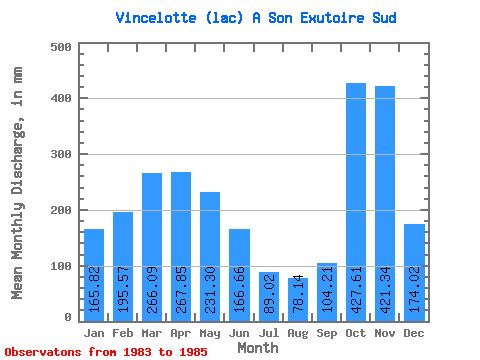
| Statistic | Jan | Feb | Mar | Apr | May | Jun | Jul | Aug | Sep | Oct | Nov | Dec | Annual |
|---|---|---|---|---|---|---|---|---|---|---|---|---|---|
| Mean | 165.79 | 197.25 | 266.05 | 267.85 | 231.26 | 166.66 | 89.01 | 78.12 | 104.21 | 427.55 | 421.34 | 173.99 | 2708.29 |
| Standard Deviation | 210.77 | 120.20 | 12.92 | 201.10 | 107.74 | 206.32 | |||||||
| Min | 16.75 | 112.26 | 256.92 | 125.65 | 155.08 | 166.66 | 89.01 | 78.12 | 104.21 | 427.55 | 421.34 | 28.10 | 2708.29 |
| Max | 314.83 | 282.25 | 275.19 | 410.06 | 307.44 | 166.66 | 89.01 | 78.12 | 104.21 | 427.55 | 421.34 | 319.88 | 2708.29 |
| Coefficient of Variation | 1.27 | 0.61 | 0.05 | 0.75 | 0.47 | 1.19 |
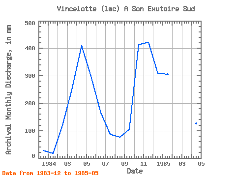
| Year | Jan | Feb | Mar | Apr | May | Jun | Jul | Aug | Sep | Oct | Nov | Dec | Annual | 1983 | 28.10 | 1984 | 16.75 | 112.26 | 256.92 | 410.06 | 307.44 | 166.66 | 89.01 | 78.12 | 104.21 | 427.55 | 421.34 | 319.88 | 2708.29 | 1985 | 314.83 | 282.25 | 275.19 | 125.65 | 155.08 |
|---|
 Return to R-Arctic Net Home Page