|
|
|||||||||||||||||
| Point ID: 5118 | Downloads | Plots | Site Data | Code: 03DC003 |
|
|
|||||||||||||||||
| Download | |
|---|---|
| Site Descriptor Information | Site Time Series Data |
| Link to all available data | |
|
|
| View: | Statistics | Time Series |
| Units: | mm |
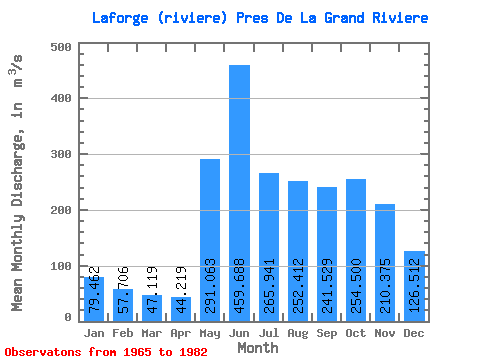
| Statistic | Jan | Feb | Mar | Apr | May | Jun | Jul | Aug | Sep | Oct | Nov | Dec | Annual |
|---|---|---|---|---|---|---|---|---|---|---|---|---|---|
| Mean | 79.46 | 57.71 | 47.12 | 44.22 | 291.06 | 459.69 | 265.94 | 252.41 | 241.53 | 254.50 | 210.38 | 126.51 | 193.38 |
| Standard Deviation | 18.15 | 12.28 | 9.32 | 6.69 | 115.68 | 117.94 | 51.26 | 97.89 | 79.94 | 61.27 | 41.44 | 24.75 | 25.13 |
| Min | 53.60 | 38.60 | 32.40 | 33.50 | 126.00 | 253.00 | 192.00 | 111.00 | 115.00 | 146.00 | 126.00 | 82.70 | 162.02 |
| Max | 131.00 | 93.70 | 66.20 | 54.90 | 559.00 | 644.00 | 405.00 | 460.00 | 389.00 | 356.00 | 286.00 | 167.00 | 245.33 |
| Coefficient of Variation | 0.23 | 0.21 | 0.20 | 0.15 | 0.40 | 0.26 | 0.19 | 0.39 | 0.33 | 0.24 | 0.20 | 0.20 | 0.13 |
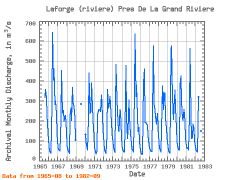
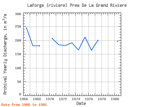
| Year | Jan | Feb | Mar | Apr | May | Jun | Jul | Aug | Sep | Oct | Nov | Dec | Annual | 1965 | 318.00 | 358.00 | 315.00 | 230.00 | 139.00 | 1966 | 72.90 | 51.10 | 39.00 | 39.00 | 280.00 | 644.00 | 405.00 | 460.00 | 283.00 | 301.00 | 236.00 | 133.00 | 245.33 | 1967 | 70.10 | 56.50 | 50.40 | 48.40 | 206.00 | 453.00 | 239.00 | 253.00 | 196.00 | 217.00 | 227.00 | 148.00 | 180.37 | 1968 | 76.40 | 55.10 | 45.40 | 37.30 | 225.00 | 265.00 | 203.00 | 368.00 | 292.00 | 271.00 | 214.00 | 104.00 | 179.68 | 1969 | 286.00 | 1970 | 131.00 | 93.70 | 66.20 | 54.00 | 210.00 | 441.00 | 238.00 | 248.00 | 389.00 | 273.00 | 207.00 | 121.00 | 205.99 | 1971 | 65.80 | 43.10 | 33.80 | 49.60 | 229.00 | 253.00 | 258.00 | 254.00 | 246.00 | 331.00 | 286.00 | 154.00 | 183.61 | 1972 | 88.90 | 57.00 | 40.80 | 35.40 | 126.00 | 358.00 | 265.00 | 275.00 | 322.00 | 283.00 | 194.00 | 133.00 | 181.51 | 1973 | 94.60 | 68.00 | 47.60 | 41.80 | 484.00 | 383.00 | 244.00 | 153.00 | 148.00 | 257.00 | 244.00 | 125.00 | 190.83 | 1974 | 71.60 | 53.30 | 46.50 | 44.40 | 168.00 | 479.00 | 213.00 | 111.00 | 147.00 | 304.00 | 214.00 | 135.00 | 165.57 | 1975 | 84.70 | 60.80 | 48.50 | 43.20 | 332.00 | 636.00 | 323.00 | 381.00 | 224.00 | 146.00 | 168.00 | 91.50 | 211.56 | 1976 | 53.60 | 38.60 | 32.40 | 33.50 | 390.00 | 460.00 | 192.00 | 193.00 | 185.00 | 179.00 | 126.00 | 82.70 | 163.82 | 1977 | 61.80 | 51.50 | 46.70 | 45.50 | 260.00 | 576.00 | 287.00 | 255.00 | 223.00 | 185.00 | 237.00 | 163.00 | 199.29 | 1978 | 92.70 | 63.20 | 49.90 | 43.00 | 267.00 | 376.00 | 256.00 | 341.00 | 341.00 | 211.00 | 161.00 | 116.00 | 193.15 | 1979 | 71.20 | 50.40 | 40.10 | 39.20 | 559.00 | 575.00 | 315.00 | 208.00 | 262.00 | 356.00 | 263.00 | 167.00 | 242.16 | 1980 | 93.30 | 65.50 | 56.40 | 54.80 | 381.00 | 425.00 | 294.00 | 213.00 | 202.00 | 258.00 | 196.00 | 111.00 | 195.83 | 1981 | 72.80 | 60.70 | 63.80 | 54.90 | 219.00 | 564.00 | 234.00 | 111.00 | 115.00 | 185.00 | 163.00 | 101.00 | 162.02 | 1982 | 70.00 | 54.80 | 46.40 | 43.50 | 321.00 | 467.00 | 269.00 | 149.00 | 173.00 |
|---|
 Return to R-Arctic Net Home Page