|
|
|||||||||||||||||
| Point ID: 5115 | Downloads | Plots | Site Data | Code: 03DB004 |
|
|
|||||||||||||||||
| Download | |
|---|---|
| Site Descriptor Information | Site Time Series Data |
| Link to all available data | |
|
|
| View: | Statistics | Time Series |
| Units: | mm |
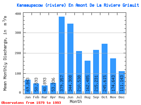
| Statistic | Jan | Feb | Mar | Apr | May | Jun | Jul | Aug | Sep | Oct | Nov | Dec | Annual |
|---|---|---|---|---|---|---|---|---|---|---|---|---|---|
| Mean | 69.84 | 50.59 | 40.89 | 53.34 | 379.36 | 344.31 | 210.54 | 162.49 | 215.23 | 245.62 | 174.64 | 111.14 | 171.74 |
| Standard Deviation | 13.77 | 9.52 | 9.27 | 31.64 | 76.01 | 73.75 | 52.86 | 50.81 | 73.98 | 50.57 | 32.17 | 26.59 | 21.11 |
| Min | 54.20 | 38.20 | 29.70 | 23.90 | 263.00 | 241.00 | 119.00 | 79.60 | 114.00 | 191.00 | 132.00 | 83.20 | 142.45 |
| Max | 99.80 | 67.40 | 61.40 | 125.00 | 509.00 | 507.00 | 295.00 | 269.00 | 354.00 | 378.00 | 233.00 | 173.00 | 207.59 |
| Coefficient of Variation | 0.20 | 0.19 | 0.23 | 0.59 | 0.20 | 0.21 | 0.25 | 0.31 | 0.34 | 0.21 | 0.18 | 0.24 | 0.12 |
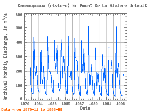
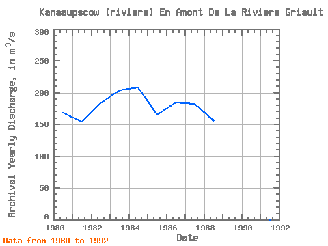
| Year | Jan | Feb | Mar | Apr | May | Jun | Jul | Aug | Sep | Oct | Nov | Dec | Annual | 1979 | 222.00 | 118.00 | 1980 | 71.80 | 51.50 | 42.30 | 45.50 | 434.00 | 320.00 | 231.00 | 181.00 | 167.00 | 236.00 | 149.00 | 90.90 | 168.33 | 1981 | 68.60 | 59.30 | 55.40 | 54.40 | 274.00 | 384.00 | 223.00 | 111.00 | 114.00 | 234.00 | 178.00 | 94.10 | 154.15 | 1982 | 61.30 | 45.40 | 37.50 | 39.00 | 438.00 | 394.00 | 279.00 | 191.00 | 201.00 | 195.00 | 176.00 | 149.00 | 183.85 | 1983 | 91.30 | 63.90 | 49.50 | 48.10 | 411.00 | 281.00 | 247.00 | 204.00 | 306.00 | 378.00 | 233.00 | 128.00 | 203.40 | 1984 | 85.30 | 67.40 | 61.40 | 125.00 | 417.00 | 334.00 | 262.00 | 152.00 | 296.00 | 304.00 | 214.00 | 173.00 | 207.59 | 1985 | 99.80 | 64.20 | 46.00 | 40.90 | 296.00 | 441.00 | 165.00 | 162.00 | 155.00 | 198.00 | 202.00 | 114.00 | 165.32 | 1986 | 69.20 | 49.90 | 40.80 | 46.70 | 426.00 | 295.00 | 295.00 | 269.00 | 281.00 | 224.00 | 138.00 | 83.20 | 184.82 | 1987 | 54.20 | 38.20 | 30.30 | 114.00 | 410.00 | 264.00 | 200.00 | 202.00 | 354.00 | 224.00 | 170.00 | 123.00 | 181.97 | 1988 | 63.10 | 44.10 | 36.00 | 83.40 | 509.00 | 241.00 | 119.00 | 93.70 | 150.00 | 244.00 | 177.00 | 123.00 | 156.94 | 1989 | 75.80 | 51.40 | 38.60 | 33.30 | 360.00 | 351.00 | 140.00 | 79.60 | 164.00 | 191.00 | 132.00 | 92.70 | 142.45 | 1990 | 61.70 | 45.60 | 35.40 | 31.90 | 276.00 | 312.00 | 208.00 | 136.00 | 155.00 | 240.00 | 149.00 | 85.10 | 144.64 | 1991 | 56.00 | 42.40 | 35.30 | 32.20 | 360.00 | 220.00 | 272.00 | 150.00 | 89.80 | 1992 | 58.00 | 40.30 | 29.70 | 23.90 | 263.00 | 507.00 | 194.00 | 158.00 | 235.00 | 253.00 | 155.00 | 92.20 | 167.43 | 1993 | 61.70 | 44.70 | 34.30 | 28.40 | 437.00 | 352.00 | 174.00 | 173.00 |
|---|
 Return to R-Arctic Net Home Page