|
|
|||||||||||||||||
| Point ID: 5115 | Downloads | Plots | Site Data | Code: 03DB004 |
|
|
|||||||||||||||||
| Download | |
|---|---|
| Site Descriptor Information | Site Time Series Data |
| Link to all available data | |
| View: | Time Series | All |
| Units: | mm |
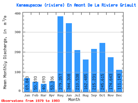
| Statistic | Jan | Feb | Mar | Apr | May | Jun | Jul | Aug | Sep | Oct | Nov | Dec | Annual |
|---|---|---|---|---|---|---|---|---|---|---|---|---|---|
| Mean | 69.84 | 50.59 | 40.89 | 53.34 | 379.36 | 344.31 | 210.54 | 162.49 | 215.23 | 245.62 | 174.64 | 111.14 | 171.74 |
| Standard Deviation | 13.77 | 9.52 | 9.27 | 31.64 | 76.01 | 73.75 | 52.86 | 50.81 | 73.98 | 50.57 | 32.17 | 26.59 | 21.11 |
| Min | 54.20 | 38.20 | 29.70 | 23.90 | 263.00 | 241.00 | 119.00 | 79.60 | 114.00 | 191.00 | 132.00 | 83.20 | 142.45 |
| Max | 99.80 | 67.40 | 61.40 | 125.00 | 509.00 | 507.00 | 295.00 | 269.00 | 354.00 | 378.00 | 233.00 | 173.00 | 207.59 |
| Coefficient of Variation | 0.20 | 0.19 | 0.23 | 0.59 | 0.20 | 0.21 | 0.25 | 0.31 | 0.34 | 0.21 | 0.18 | 0.24 | 0.12 |
 Return to R-Arctic Net Home Page