|
|
|||||||||||||||||
| Point ID: 5098 | Downloads | Plots | Site Data | Code: 03BD002 |
|
|
|||||||||||||||||
| Download | |
|---|---|
| Site Descriptor Information | Site Time Series Data |
| Link to all available data | |
|
|
| View: | Statistics | Time Series |
| Units: | mm |
| Statistic | Jan | Feb | Mar | Apr | May | Jun | Jul | Aug | Sep | Oct | Nov | Dec | Annual |
|---|---|---|---|---|---|---|---|---|---|---|---|---|---|
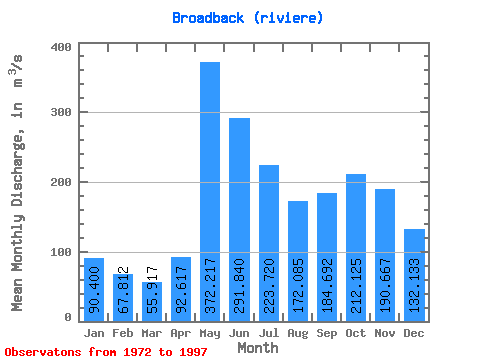
| Mean | 90.40 | 67.81 | 55.92 | 92.62 | 372.22 | 291.84 | 223.72 | 172.09 | 184.69 | 212.12 | 190.67 | 132.13 | 173.46 |
| Standard Deviation | 14.32 | 10.82 | 9.36 | 38.14 | 79.96 | 92.52 | 47.56 | 32.53 | 55.79 | 52.49 | 42.47 | 24.03 | 17.32 |
| Min | 58.60 | 45.50 | 38.50 | 46.00 | 219.00 | 188.00 | 147.00 | 95.20 | 108.00 | 137.00 | 119.00 | 82.20 | 139.88 |
| Max | 115.00 | 91.80 | 74.80 | 169.00 | 534.00 | 615.00 | 335.00 | 251.00 | 341.00 | 363.00 | 290.00 | 174.00 | 214.32 |
| Coefficient of Variation | 0.16 | 0.16 | 0.17 | 0.41 | 0.21 | 0.32 | 0.21 | 0.19 | 0.30 | 0.25 | 0.22 | 0.18 | 0.10 |
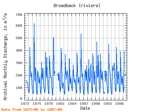
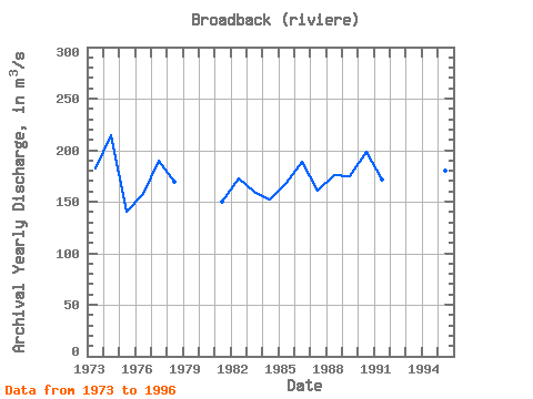
| Year | Jan | Feb | Mar | Apr | May | Jun | Jul | Aug | Sep | Oct | Nov | Dec | Annual | 1972 | 157.00 | 136.00 | 137.00 | 119.00 | 82.20 | 1973 | 69.40 | 64.00 | 58.80 | 105.00 | 423.00 | 276.00 | 278.00 | 187.00 | 194.00 | 220.00 | 182.00 | 133.00 | 182.52 | 1974 | 88.70 | 66.40 | 53.60 | 54.20 | 397.00 | 615.00 | 307.00 | 171.00 | 151.00 | 259.00 | 258.00 | 151.00 | 214.32 | 1975 | 92.30 | 63.80 | 48.40 | 46.00 | 219.00 | 238.00 | 203.00 | 168.00 | 135.00 | 152.00 | 186.00 | 127.00 | 139.88 | 1976 | 80.80 | 59.30 | 48.70 | 99.00 | 305.00 | 208.00 | 166.00 | 179.00 | 256.00 | 220.00 | 156.00 | 112.00 | 157.48 | 1977 | 89.50 | 67.70 | 58.80 | 120.00 | 388.00 | 302.00 | 214.00 | 179.00 | 341.00 | 194.00 | 187.00 | 132.00 | 189.42 | 1978 | 86.40 | 63.50 | 52.50 | 50.60 | 313.00 | 355.00 | 263.00 | 192.00 | 180.00 | 185.00 | 175.00 | 117.00 | 169.42 | 1979 | 67.20 | 47.10 | 38.50 | 153.00 | 505.00 | 486.00 | 240.00 | 198.00 | 226.00 | 1980 | 204.00 | 215.00 | 173.00 | 157.00 | 222.00 | 187.00 | 129.00 | 1981 | 87.90 | 67.40 | 72.10 | 131.00 | 418.00 | 288.00 | 158.00 | 95.20 | 108.00 | 140.00 | 133.00 | 103.00 | 150.13 | 1982 | 74.50 | 57.00 | 47.00 | 61.10 | 368.00 | 233.00 | 259.00 | 168.00 | 195.00 | 216.00 | 234.00 | 164.00 | 173.05 | 1983 | 115.00 | 91.80 | 71.70 | 71.60 | 334.00 | 328.00 | 171.00 | 130.00 | 147.00 | 187.00 | 148.00 | 124.00 | 159.93 | 1984 | 101.00 | 85.60 | 74.80 | 128.00 | 282.00 | 201.00 | 196.00 | 157.00 | 138.00 | 164.00 | 159.00 | 141.00 | 152.28 | 1985 | 103.00 | 71.50 | 54.70 | 63.60 | 381.00 | 338.00 | 221.00 | 168.00 | 133.00 | 163.00 | 185.00 | 136.00 | 168.15 | 1986 | 98.80 | 72.70 | 57.00 | 128.00 | 534.00 | 272.00 | 281.00 | 188.00 | 214.00 | 204.00 | 136.00 | 85.00 | 189.21 | 1987 | 58.60 | 45.50 | 42.40 | 166.00 | 231.00 | 246.00 | 212.00 | 158.00 | 173.00 | 280.00 | 181.00 | 137.00 | 160.88 | 1988 | 89.90 | 62.10 | 47.70 | 169.00 | 324.00 | 188.00 | 175.00 | 141.00 | 185.00 | 260.00 | 290.00 | 174.00 | 175.47 | 1989 | 111.00 | 76.40 | 57.10 | 58.70 | 372.00 | 330.00 | 210.00 | 162.00 | 128.00 | 209.00 | 232.00 | 155.00 | 175.10 | 1990 | 98.00 | 71.70 | 56.90 | 76.10 | 468.00 | 245.00 | 192.00 | 180.00 | 199.00 | 363.00 | 258.00 | 168.00 | 197.97 | 1991 | 105.00 | 74.70 | 58.80 | 122.00 | 372.00 | 255.00 | 181.00 | 164.00 | 234.00 | 208.00 | 171.00 | 108.00 | 171.12 | 1992 | 79.40 | 62.50 | 52.30 | 59.60 | 231.00 | 147.00 | 170.00 | 231.00 | 232.00 | 203.00 | 141.00 | 1993 | 91.80 | 66.10 | 51.00 | 81.60 | 450.00 | 299.00 | 269.00 | 251.00 | 228.00 | 197.00 | 166.00 | 109.00 | 188.29 | 1994 | 76.40 | 57.80 | 46.60 | 53.70 | 276.00 | 237.00 | 241.00 | 248.00 | 283.00 | 297.00 | 208.00 | 148.00 | 181.04 | 1995 | 104.00 | 79.40 | 68.30 | 70.40 | 426.00 | 322.00 | 234.00 | 133.00 | 129.00 | 219.00 | 230.00 | 149.00 | 180.34 | 1996 | 100.00 | 77.50 | 63.70 | 77.50 | 389.00 | 293.00 | 225.00 | 150.00 | 123.00 | 163.00 | 192.00 | 146.00 | 166.64 | 1997 | 101.00 | 76.00 | 60.60 | 77.10 | 386.00 | 306.00 | 335.00 | 207.00 | 178.00 |
|---|
 Return to R-Arctic Net Home Page