|
|
|||||||||||||||||
| Point ID: 5097 | Downloads | Plots | Site Data | Code: 03BD001 |
|
|
|||||||||||||||||
| Download | |
|---|---|
| Site Descriptor Information | Site Time Series Data |
| Link to all available data | |
|
|
| View: | Statistics | Time Series |
| Units: | mm |
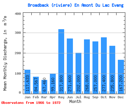
| Statistic | Jan | Feb | Mar | Apr | May | Jun | Jul | Aug | Sep | Oct | Nov | Dec | Annual |
|---|---|---|---|---|---|---|---|---|---|---|---|---|---|
| Mean | 117.63 | 84.57 | 67.46 | 99.16 | 317.80 | 271.60 | 202.00 | 268.00 | 257.00 | 277.40 | 235.80 | 167.20 | 192.14 |
| Standard Deviation | 32.71 | 15.46 | 7.30 | 73.74 | 92.19 | 107.17 | 35.65 | 77.47 | 123.00 | 117.40 | 76.66 | 53.64 | 38.88 |
| Min | 85.90 | 71.30 | 55.90 | 46.80 | 224.00 | 152.00 | 153.00 | 181.00 | 126.00 | 188.00 | 140.00 | 116.00 | 145.69 |
| Max | 177.00 | 113.00 | 73.60 | 229.00 | 444.00 | 410.00 | 233.00 | 348.00 | 439.00 | 435.00 | 335.00 | 252.00 | 240.53 |
| Coefficient of Variation | 0.28 | 0.18 | 0.11 | 0.74 | 0.29 | 0.40 | 0.18 | 0.29 | 0.48 | 0.42 | 0.33 | 0.32 | 0.20 |
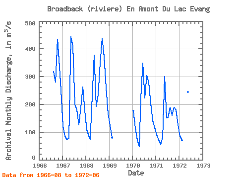
| Year | Jan | Feb | Mar | Apr | May | Jun | Jul | Aug | Sep | Oct | Nov | Dec | Annual | 1966 | 318.00 | 281.00 | 435.00 | 335.00 | 252.00 | 1967 | 121.00 | 85.90 | 72.60 | 77.50 | 444.00 | 410.00 | 199.00 | 181.00 | 126.00 | 188.00 | 263.00 | 176.00 | 195.33 | 1968 | 109.00 | 86.80 | 73.60 | 229.00 | 377.00 | 193.00 | 233.00 | 348.00 | 439.00 | 372.00 | 261.00 | 165.00 | 240.53 | 1969 | 122.00 | 79.00 | 1970 | 177.00 | 113.00 | 70.40 | 46.80 | 224.00 | 349.00 | 223.00 | 304.00 | 278.00 | 203.00 | 140.00 | 116.00 | 187.02 | 1971 | 90.90 | 71.40 | 55.90 | 79.10 | 300.00 | 152.00 | 153.00 | 189.00 | 161.00 | 189.00 | 180.00 | 127.00 | 145.69 | 1972 | 85.90 | 71.30 | 64.80 | 63.40 | 244.00 | 254.00 |
|---|
 Return to R-Arctic Net Home Page