|
|
|||||||||||||||||
| Point ID: 5097 | Downloads | Plots | Site Data | Code: 03BD001 |
|
|
|||||||||||||||||
| Download | |
|---|---|
| Site Descriptor Information | Site Time Series Data |
| Link to all available data | |
|
|
| View: | Statistics | Time Series |
| Units: | m3/s |
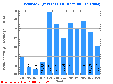
| Statistic | Jan | Feb | Mar | Apr | May | Jun | Jul | Aug | Sep | Oct | Nov | Dec | Annual |
|---|---|---|---|---|---|---|---|---|---|---|---|---|---|
| Mean | 28.90 | 18.93 | 16.57 | 23.58 | 78.08 | 64.59 | 49.63 | 65.84 | 61.11 | 68.15 | 56.07 | 41.08 | 556.34 |
| Standard Deviation | 8.04 | 3.46 | 1.79 | 17.54 | 22.65 | 25.48 | 8.76 | 19.03 | 29.25 | 28.84 | 18.23 | 13.18 | 112.58 |
| Min | 21.11 | 15.96 | 13.73 | 11.13 | 55.03 | 36.15 | 37.59 | 44.47 | 29.96 | 46.19 | 33.29 | 28.50 | 421.84 |
| Max | 43.49 | 25.30 | 18.08 | 54.46 | 109.09 | 97.50 | 57.24 | 85.50 | 104.39 | 106.87 | 79.66 | 61.91 | 696.44 |
| Coefficient of Variation | 0.28 | 0.18 | 0.11 | 0.74 | 0.29 | 0.40 | 0.18 | 0.29 | 0.48 | 0.42 | 0.33 | 0.32 | 0.20 |
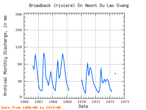
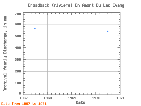
| Year | Jan | Feb | Mar | Apr | May | Jun | Jul | Aug | Sep | Oct | Nov | Dec | Annual | 1966 | 78.13 | 66.82 | 106.87 | 79.66 | 61.91 | 1967 | 29.73 | 19.23 | 17.84 | 18.43 | 109.09 | 97.50 | 48.89 | 44.47 | 29.96 | 46.19 | 62.54 | 43.24 | 565.57 | 1968 | 26.78 | 19.43 | 18.08 | 54.46 | 92.62 | 45.90 | 57.24 | 85.50 | 104.39 | 91.40 | 62.06 | 40.54 | 696.44 | 1969 | 29.97 | 17.68 | 1970 | 43.49 | 25.30 | 17.30 | 11.13 | 55.03 | 82.99 | 54.79 | 74.69 | 66.11 | 49.88 | 33.29 | 28.50 | 541.49 | 1971 | 22.33 | 15.98 | 13.73 | 18.81 | 73.71 | 36.15 | 37.59 | 46.44 | 38.29 | 46.44 | 42.80 | 31.20 | 421.84 | 1972 | 21.11 | 15.96 | 15.92 | 15.08 | 59.95 | 60.40 |
|---|
 Return to R-Arctic Net Home Page