|
|
|||||||||||||||||
| Point ID: 4369 | Downloads | Plots | Site Data | Other Close Sites | Code: 04LG004 |
|
|
|||||||||||||||||
| Download | |
|---|---|
| Site Descriptor Information | Site Time Series Data |
| Link to all available data | |
|
|
| View: | Statistics | Time Series |
| Units: | mm |
| Statistic | Jan | Feb | Mar | Apr | May | Jun | Jul | Aug | Sep | Oct | Nov | Dec | Annual |
|---|---|---|---|---|---|---|---|---|---|---|---|---|---|
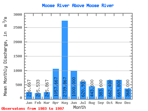
| Mean | 236.67 | 205.53 | 245.87 | 1057.67 | 2739.87 | 1000.00 | 620.93 | 443.60 | 383.60 | 662.40 | 669.80 | 368.00 | 719.49 |
| Standard Deviation | 40.14 | 30.08 | 68.54 | 526.32 | 1207.48 | 462.94 | 304.82 | 285.70 | 228.48 | 312.26 | 232.30 | 121.62 | 120.19 |
| Min | 159.00 | 140.00 | 137.00 | 264.00 | 618.00 | 444.00 | 167.00 | 133.00 | 115.00 | 127.00 | 420.00 | 210.00 | 497.42 |
| Max | 302.00 | 249.00 | 415.00 | 1810.00 | 5130.00 | 2100.00 | 1300.00 | 1190.00 | 833.00 | 1180.00 | 1340.00 | 693.00 | 940.08 |
| Coefficient of Variation | 0.17 | 0.15 | 0.28 | 0.50 | 0.44 | 0.46 | 0.49 | 0.64 | 0.60 | 0.47 | 0.35 | 0.33 | 0.17 |
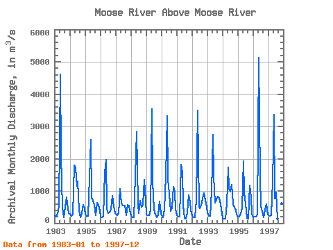
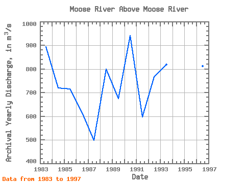
| Year | Jan | Feb | Mar | Apr | May | Jun | Jul | Aug | Sep | Oct | Nov | Dec | Annual | 1983 | 253.00 | 207.00 | 284.00 | 526.00 | 4610.00 | 2100.00 | 481.00 | 193.00 | 516.00 | 804.00 | 439.00 | 304.00 | 893.08 | 1984 | 283.00 | 233.00 | 275.00 | 1790.00 | 1700.00 | 1140.00 | 1300.00 | 389.00 | 184.00 | 307.00 | 575.00 | 456.00 | 719.33 | 1985 | 259.00 | 201.00 | 233.00 | 1400.00 | 2590.00 | 810.00 | 701.00 | 578.00 | 241.00 | 638.00 | 571.00 | 370.00 | 716.00 | 1986 | 206.00 | 179.00 | 213.00 | 1570.00 | 1960.00 | 444.00 | 319.00 | 337.00 | 444.00 | 856.00 | 520.00 | 317.00 | 613.75 | 1987 | 287.00 | 249.00 | 316.00 | 1070.00 | 618.00 | 577.00 | 543.00 | 552.00 | 245.00 | 568.00 | 546.00 | 398.00 | 497.42 | 1988 | 225.00 | 193.00 | 180.00 | 1460.00 | 2820.00 | 590.00 | 304.00 | 694.00 | 501.00 | 577.00 | 1340.00 | 693.00 | 798.08 | 1989 | 263.00 | 249.00 | 246.00 | 400.00 | 3530.00 | 1290.00 | 415.00 | 261.00 | 187.00 | 248.00 | 687.00 | 317.00 | 674.42 | 1990 | 237.00 | 177.00 | 415.00 | 1470.00 | 3320.00 | 1350.00 | 910.00 | 376.00 | 484.00 | 1130.00 | 984.00 | 428.00 | 940.08 | 1991 | 237.00 | 208.00 | 213.00 | 1810.00 | 1570.00 | 544.00 | 167.00 | 133.00 | 329.00 | 862.00 | 665.00 | 421.00 | 596.58 | 1992 | 220.00 | 177.00 | 186.00 | 713.00 | 3490.00 | 514.00 | 452.00 | 547.00 | 758.00 | 935.00 | 712.00 | 502.00 | 767.17 | 1993 | 302.00 | 233.00 | 223.00 | 987.00 | 2740.00 | 1450.00 | 636.00 | 746.00 | 833.00 | 793.00 | 589.00 | 282.00 | 817.83 | 1994 | 159.00 | 140.00 | 137.00 | 622.00 | 1730.00 | 1070.00 | 981.00 | 1190.00 | 602.00 | 492.00 | 420.00 | 261.00 | 650.33 | 1995 | 199.00 | 214.00 | 322.00 | 473.00 | 1920.00 | 964.00 | 583.00 | 158.00 | 141.00 | 1180.00 | 799.00 | 283.00 | 603.00 | 1996 | 179.00 | 197.00 | 208.00 | 264.00 | 5130.00 | 1400.00 | 555.00 | 357.00 | 174.00 | 419.00 | 587.00 | 278.00 | 812.33 | 1997 | 241.00 | 226.00 | 237.00 | 1310.00 | 3370.00 | 757.00 | 967.00 | 143.00 | 115.00 | 127.00 | 613.00 | 210.00 | 693.00 |
|---|
| Other Close Sites | ||||||
|---|---|---|---|---|---|---|
| PointID | Latitude | Longitude | Drainage Area | Source | Name | |
| 4367 | "MOOSE RIVER AT MOOSE RIVER" | 50.81 | -647140 | Hydat | ||
| 4381 | "ABITIBI RIVER AT ONAKAWANA" | 50.60 | -641576 | Hydat | ||
 Return to R-Arctic Net Home Page