|
|
|||||||||||||||||
| Point ID: 4369 | Downloads | Plots | Site Data | Other Close Sites | Code: 04LG004 |
|
|
|||||||||||||||||
| Download | |
|---|---|
| Site Descriptor Information | Site Time Series Data |
| Link to all available data | |
| View: | Time Series | All |
| Units: | mm |
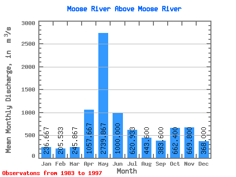
| Statistic | Jan | Feb | Mar | Apr | May | Jun | Jul | Aug | Sep | Oct | Nov | Dec | Annual |
|---|---|---|---|---|---|---|---|---|---|---|---|---|---|
| Mean | 236.67 | 205.53 | 245.87 | 1057.67 | 2739.87 | 1000.00 | 620.93 | 443.60 | 383.60 | 662.40 | 669.80 | 368.00 | 719.49 |
| Standard Deviation | 40.14 | 30.08 | 68.54 | 526.32 | 1207.48 | 462.94 | 304.82 | 285.70 | 228.48 | 312.26 | 232.30 | 121.62 | 120.19 |
| Min | 159.00 | 140.00 | 137.00 | 264.00 | 618.00 | 444.00 | 167.00 | 133.00 | 115.00 | 127.00 | 420.00 | 210.00 | 497.42 |
| Max | 302.00 | 249.00 | 415.00 | 1810.00 | 5130.00 | 2100.00 | 1300.00 | 1190.00 | 833.00 | 1180.00 | 1340.00 | 693.00 | 940.08 |
| Coefficient of Variation | 0.17 | 0.15 | 0.28 | 0.50 | 0.44 | 0.46 | 0.49 | 0.64 | 0.60 | 0.47 | 0.35 | 0.33 | 0.17 |
| Other Close Sites | ||||||
|---|---|---|---|---|---|---|
| PointID | Latitude | Longitude | Drainage Area | Source | Name | |
| 4367 | "MOOSE RIVER AT MOOSE RIVER" | 50.81 | -647140 | Hydat | ||
| 4381 | "ABITIBI RIVER AT ONAKAWANA" | 50.60 | -641576 | Hydat | ||
 Return to R-Arctic Net Home Page