|
|
|||||||||||||||||
| Point ID: 4344 | Downloads | Plots | Site Data | Code: 04GD001 |
|
|
|||||||||||||||||
| Download | |
|---|---|
| Site Descriptor Information | Site Time Series Data |
| Link to all available data | |
|
|
| View: | Statistics | Time Series |
| Units: | mm |
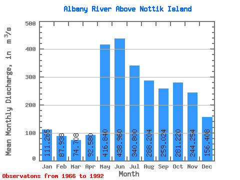
| Statistic | Jan | Feb | Mar | Apr | May | Jun | Jul | Aug | Sep | Oct | Nov | Dec | Annual |
|---|---|---|---|---|---|---|---|---|---|---|---|---|---|
| Mean | 111.27 | 87.94 | 74.71 | 92.58 | 416.84 | 438.96 | 340.80 | 288.20 | 259.02 | 281.22 | 244.25 | 156.41 | 233.38 |
| Standard Deviation | 65.07 | 51.57 | 40.18 | 41.48 | 146.39 | 227.53 | 160.51 | 158.15 | 162.42 | 168.88 | 149.34 | 89.69 | 90.43 |
| Min | 42.50 | 31.90 | 29.00 | 38.60 | 198.00 | 208.00 | 140.00 | 81.80 | 44.70 | 30.40 | 34.60 | 47.40 | 118.03 |
| Max | 282.00 | 223.00 | 199.00 | 217.00 | 786.00 | 1300.00 | 818.00 | 693.00 | 563.00 | 620.00 | 597.00 | 389.00 | 425.75 |
| Coefficient of Variation | 0.58 | 0.59 | 0.54 | 0.45 | 0.35 | 0.52 | 0.47 | 0.55 | 0.63 | 0.60 | 0.61 | 0.57 | 0.39 |
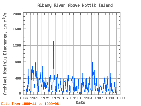
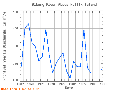
| Year | Jan | Feb | Mar | Apr | May | Jun | Jul | Aug | Sep | Oct | Nov | Dec | Annual | 1966 | 157.00 | 101.00 | 1967 | 77.70 | 68.80 | 67.70 | 70.00 | 366.00 | 624.00 | 274.00 | 252.00 | 123.00 | 88.10 | 133.00 | 81.00 | 185.44 | 1968 | 73.50 | 67.50 | 57.20 | 93.50 | 608.00 | 561.00 | 542.00 | 693.00 | 563.00 | 574.00 | 597.00 | 389.00 | 401.56 | 1969 | 282.00 | 216.00 | 168.00 | 179.00 | 672.00 | 775.00 | 575.00 | 344.00 | 480.00 | 580.00 | 512.00 | 326.00 | 425.75 | 1970 | 242.00 | 183.00 | 118.00 | 74.50 | 347.00 | 407.00 | 377.00 | 352.00 | 433.00 | 534.00 | 440.00 | 317.00 | 318.71 | 1971 | 256.00 | 223.00 | 199.00 | 217.00 | 683.00 | 406.00 | 200.00 | 294.00 | 135.00 | 316.00 | 388.00 | 243.00 | 296.67 | 1972 | 198.00 | 167.00 | 149.00 | 153.00 | 414.00 | 294.00 | 164.00 | 188.00 | 184.00 | 302.00 | 216.00 | 139.00 | 214.00 | 1973 | 96.50 | 75.50 | 67.60 | 82.40 | 424.00 | 328.00 | 421.00 | 472.00 | 352.00 | 255.00 | 198.00 | 127.00 | 241.58 | 1974 | 97.40 | 79.70 | 64.90 | 61.10 | 542.00 | 1300.00 | 818.00 | 454.00 | 460.00 | 471.00 | 257.00 | 157.00 | 396.84 | 1975 | 108.00 | 81.60 | 68.20 | 75.60 | 323.00 | 495.00 | 436.00 | 493.00 | 302.00 | 233.00 | 255.00 | 164.00 | 252.87 | 1976 | 111.00 | 80.70 | 64.90 | 94.70 | 396.00 | 262.00 | 209.00 | 124.00 | 99.50 | 154.00 | 110.00 | 78.30 | 148.68 | 1977 | 59.20 | 47.80 | 42.10 | 91.60 | 370.00 | 286.00 | 332.00 | 303.00 | 349.00 | 259.00 | 171.00 | 120.00 | 202.56 | 1978 | 87.90 | 72.20 | 63.00 | 60.50 | 294.00 | 463.00 | 319.00 | 466.00 | 418.00 | 265.00 | 188.00 | 120.00 | 234.72 | 1979 | 80.50 | 60.70 | 61.10 | 76.40 | 355.00 | 374.00 | 336.00 | 366.00 | 452.00 | 382.00 | 367.00 | 221.00 | 260.98 | 1980 | 140.00 | 102.00 | 73.30 | 80.70 | 394.00 | 208.00 | 140.00 | 100.00 | 110.00 | 226.00 | 190.00 | 107.00 | 155.92 | 1981 | 71.70 | 56.00 | 63.70 | 68.10 | 339.00 | 371.00 | 208.00 | 81.80 | 44.70 | 30.40 | 34.60 | 47.40 | 118.03 | 1982 | 44.20 | 36.90 | 29.00 | 38.60 | 499.00 | 510.00 | 278.00 | 177.00 | 244.00 | 298.00 | 251.00 | 144.00 | 212.47 | 1983 | 87.50 | 67.20 | 63.80 | 68.20 | 228.00 | 244.00 | 514.00 | 274.00 | 151.00 | 191.00 | 191.00 | 131.00 | 184.22 | 1984 | 94.80 | 74.60 | 60.20 | 142.00 | 433.00 | 437.00 | 283.00 | 205.00 | 115.00 | 108.00 | 119.00 | 107.00 | 181.55 | 1985 | 91.50 | 80.20 | 69.80 | 112.00 | 786.00 | 562.00 | 540.00 | 525.00 | 489.00 | 620.00 | 580.00 | 303.00 | 396.54 | 1986 | 169.00 | 113.00 | 86.10 | 94.40 | 471.00 | 315.00 | 242.00 | 140.00 | 89.80 | 154.00 | 148.00 | 94.70 | 176.42 | 1987 | 69.40 | 59.30 | 58.20 | 115.00 | 251.00 | 216.00 | 195.00 | 198.00 | 235.00 | 156.00 | 129.00 | 91.70 | 147.80 | 1988 | 58.40 | 42.30 | 39.90 | 84.40 | 198.00 | 253.00 | 300.00 | 263.00 | 356.00 | 434.00 | 293.00 | 184.00 | 208.83 | 1989 | 110.00 | 79.10 | 65.10 | 66.40 | 413.00 | 456.00 | 304.00 | 178.00 | 140.00 | 123.00 | 109.00 | 67.50 | 175.93 | 1990 | 42.50 | 31.90 | 35.00 | 43.30 | 323.00 | 522.00 | 361.00 | 176.00 | 100.00 | 125.00 | 131.00 | 85.00 | 164.64 | 1991 | 63.20 | 54.10 | 48.40 | 72.10 | 292.00 | 305.00 | 152.00 | 86.30 | 50.60 | 152.00 | 186.00 | 121.00 | 131.89 | 1992 | 81.00 | 66.30 | 59.20 |
|---|
 Return to R-Arctic Net Home Page