|
|
|||||||||||||||||
| Point ID: 4344 | Downloads | Plots | Site Data | Code: 04GD001 |
|
|
|||||||||||||||||
| Download | |
|---|---|
| Site Descriptor Information | Site Time Series Data |
| Link to all available data | |
| View: | Time Series | All |
| Units: | mm |
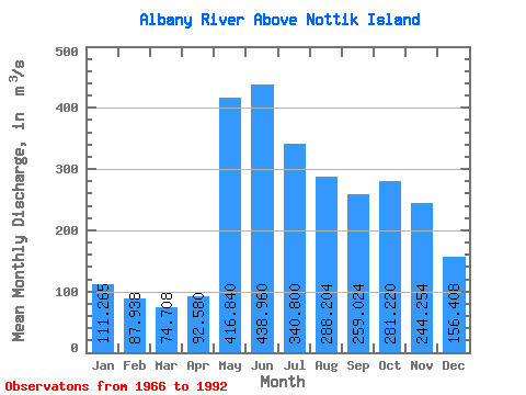
| Statistic | Jan | Feb | Mar | Apr | May | Jun | Jul | Aug | Sep | Oct | Nov | Dec | Annual |
|---|---|---|---|---|---|---|---|---|---|---|---|---|---|
| Mean | 111.27 | 87.94 | 74.71 | 92.58 | 416.84 | 438.96 | 340.80 | 288.20 | 259.02 | 281.22 | 244.25 | 156.41 | 233.38 |
| Standard Deviation | 65.07 | 51.57 | 40.18 | 41.48 | 146.39 | 227.53 | 160.51 | 158.15 | 162.42 | 168.88 | 149.34 | 89.69 | 90.43 |
| Min | 42.50 | 31.90 | 29.00 | 38.60 | 198.00 | 208.00 | 140.00 | 81.80 | 44.70 | 30.40 | 34.60 | 47.40 | 118.03 |
| Max | 282.00 | 223.00 | 199.00 | 217.00 | 786.00 | 1300.00 | 818.00 | 693.00 | 563.00 | 620.00 | 597.00 | 389.00 | 425.75 |
| Coefficient of Variation | 0.58 | 0.59 | 0.54 | 0.45 | 0.35 | 0.52 | 0.47 | 0.55 | 0.63 | 0.60 | 0.61 | 0.57 | 0.39 |
 Return to R-Arctic Net Home Page