|
|
|||||||||||||||||
| Point ID: 4318 | Downloads | Plots | Site Data | Code: 04CA002 |
|
|
|||||||||||||||||
| Download | |
|---|---|
| Site Descriptor Information | Site Time Series Data |
| Link to all available data | |
|
|
| View: | Statistics | Time Series |
| Units: | mm |
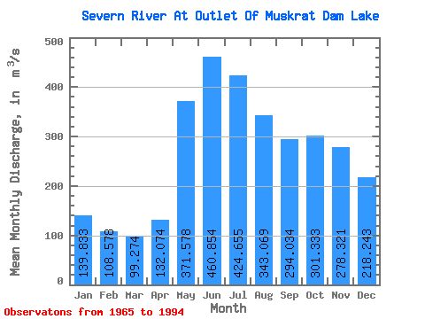
| Statistic | Jan | Feb | Mar | Apr | May | Jun | Jul | Aug | Sep | Oct | Nov | Dec | Annual |
|---|---|---|---|---|---|---|---|---|---|---|---|---|---|
| Mean | 139.83 | 108.58 | 99.27 | 132.07 | 371.58 | 460.85 | 424.65 | 343.07 | 294.03 | 301.33 | 278.32 | 218.24 | 259.80 |
| Standard Deviation | 52.07 | 30.87 | 27.61 | 48.69 | 150.45 | 189.69 | 189.32 | 147.85 | 152.91 | 188.34 | 169.56 | 135.66 | 92.62 |
| Min | 43.20 | 35.70 | 35.60 | 63.50 | 96.60 | 93.90 | 168.00 | 128.00 | 107.00 | 102.00 | 87.30 | 63.80 | 124.07 |
| Max | 275.00 | 163.00 | 142.00 | 250.00 | 625.00 | 846.00 | 881.00 | 617.00 | 702.00 | 1100.00 | 982.00 | 753.00 | 512.17 |
| Coefficient of Variation | 0.37 | 0.28 | 0.28 | 0.37 | 0.41 | 0.41 | 0.45 | 0.43 | 0.52 | 0.62 | 0.61 | 0.62 | 0.36 |
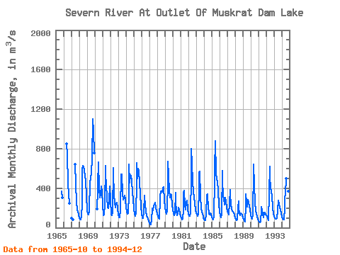
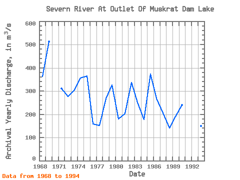
| Year | Jan | Feb | Mar | Apr | May | Jun | Jul | Aug | Sep | Oct | Nov | Dec | Annual | 1965 | 369.00 | 307.00 | 1966 | 846.00 | 737.00 | 448.00 | 338.00 | 248.00 | 1967 | 97.20 | 90.00 | 83.00 | 638.00 | 440.00 | 260.00 | 174.00 | 165.00 | 125.00 | 1968 | 94.30 | 82.20 | 79.30 | 109.00 | 243.00 | 588.00 | 626.00 | 617.00 | 578.00 | 524.00 | 480.00 | 329.00 | 362.48 | 1969 | 178.00 | 138.00 | 135.00 | 170.00 | 478.00 | 460.00 | 489.00 | 561.00 | 702.00 | 1100.00 | 982.00 | 753.00 | 512.17 | 1970 | 189.00 | 380.00 | 436.00 | 664.00 | 394.00 | 304.00 | 331.00 | 419.00 | 362.00 | 1971 | 234.00 | 127.00 | 133.00 | 236.00 | 625.00 | 545.00 | 425.00 | 315.00 | 207.00 | 199.00 | 275.00 | 419.00 | 311.67 | 1972 | 275.00 | 135.00 | 129.00 | 151.00 | 604.00 | 544.00 | 341.00 | 248.00 | 204.00 | 250.00 | 252.00 | 196.00 | 277.42 | 1973 | 130.00 | 101.00 | 107.00 | 186.00 | 543.00 | 495.00 | 538.00 | 344.00 | 280.00 | 300.00 | 323.00 | 281.00 | 302.33 | 1974 | 202.00 | 162.00 | 138.00 | 144.00 | 343.00 | 643.00 | 454.00 | 535.00 | 526.00 | 472.00 | 360.00 | 283.00 | 355.17 | 1975 | 196.00 | 135.00 | 118.00 | 144.00 | 453.00 | 656.00 | 499.00 | 598.00 | 571.00 | 465.00 | 332.00 | 216.00 | 365.25 | 1976 | 141.00 | 94.40 | 94.40 | 158.00 | 328.00 | 308.00 | 232.00 | 159.00 | 123.00 | 102.00 | 87.30 | 63.80 | 157.57 | 1977 | 43.20 | 35.70 | 35.60 | 78.60 | 195.00 | 187.00 | 178.00 | 219.00 | 232.00 | 252.00 | 207.00 | 166.00 | 152.43 | 1978 | 140.00 | 119.00 | 95.60 | 91.00 | 291.00 | 309.00 | 371.00 | 361.00 | 363.00 | 397.00 | 409.00 | 275.00 | 268.47 | 1979 | 202.00 | 163.00 | 142.00 | 176.00 | 459.00 | 671.00 | 530.00 | 378.00 | 302.00 | 337.00 | 329.00 | 232.00 | 326.75 | 1980 | 181.00 | 147.00 | 122.00 | 137.00 | 353.00 | 259.00 | 168.00 | 128.00 | 140.00 | 201.00 | 180.00 | 139.00 | 179.58 | 1981 | 115.00 | 93.50 | 80.80 | 86.50 | 179.00 | 357.00 | 374.00 | 228.00 | 182.00 | 258.00 | 277.00 | 199.00 | 202.48 | 1982 | 135.00 | 120.00 | 121.00 | 147.00 | 511.00 | 798.00 | 641.00 | 469.00 | 354.00 | 313.00 | 245.00 | 173.00 | 335.58 | 1983 | 145.00 | 130.00 | 121.00 | 134.00 | 410.00 | 565.00 | 571.00 | 319.00 | 200.00 | 157.00 | 146.00 | 104.00 | 250.17 | 1984 | 84.40 | 76.60 | 73.00 | 131.00 | 332.00 | 343.00 | 308.00 | 216.00 | 142.00 | 135.00 | 147.00 | 135.00 | 176.92 | 1985 | 104.00 | 89.00 | 83.30 | 114.00 | 485.00 | 591.00 | 881.00 | 557.00 | 482.00 | 480.00 | 372.00 | 235.00 | 372.77 | 1986 | 158.00 | 122.00 | 104.00 | 134.00 | 574.00 | 486.00 | 322.00 | 295.00 | 236.00 | 308.00 | 263.00 | 201.00 | 266.92 | 1987 | 168.00 | 146.00 | 131.00 | 250.00 | 385.00 | 344.00 | 235.00 | 193.00 | 169.00 | 164.00 | 157.00 | 124.00 | 205.50 | 1988 | 98.90 | 83.20 | 74.20 | 83.10 | 205.00 | 270.00 | 199.00 | 140.00 | 122.00 | 149.00 | 140.00 | 123.00 | 140.62 | 1989 | 101.00 | 83.20 | 68.50 | 64.00 | 220.00 | 340.00 | 263.00 | 211.00 | 286.00 | 262.00 | 210.00 | 181.00 | 190.81 | 1990 | 132.00 | 100.00 | 92.20 | 133.00 | 602.00 | 641.00 | 424.00 | 261.00 | 166.00 | 141.00 | 111.00 | 85.00 | 240.68 | 1991 | 69.50 | 59.50 | 52.30 | 63.50 | 178.00 | 212.00 | 179.00 | 133.00 | 107.00 | 151.00 | 151.00 | 133.00 | 124.07 | 1992 | 125.00 | 114.00 | 95.10 | 78.30 | 353.00 | 621.00 | 513.00 | 408.00 | 361.00 | 321.00 | 203.00 | 142.00 | 277.87 | 1993 | 112.00 | 97.70 | 91.20 | 93.10 | 96.60 | 93.90 | 173.00 | 278.00 | 230.00 | 203.00 | 173.00 | 144.00 | 148.79 | 1994 | 114.00 | 87.60 | 80.90 | 84.90 | 207.00 | 295.00 | 342.00 | 496.00 | 360.00 | 277.00 | 369.00 | 292.00 | 250.45 |
|---|
 Return to R-Arctic Net Home Page