|
|
|||||||||||||||||
| Point ID: 430 | Downloads | Plots | Site Data | Code: 05CJ009 |
|
|
|||||||||||||||||
| Download | |
|---|---|
| Site Descriptor Information | Site Time Series Data |
| Link to all available data | |
|
|
| View: | Statistics | Time Series |
| Units: | mm |
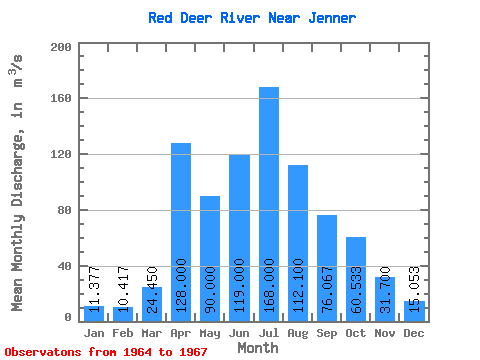
| Statistic | Jan | Feb | Mar | Apr | May | Jun | Jul | Aug | Sep | Oct | Nov | Dec | Annual |
|---|---|---|---|---|---|---|---|---|---|---|---|---|---|
| Mean | 11.38 | 10.42 | 24.45 | 128.00 | 90.00 | 119.00 | 168.00 | 112.10 | 76.07 | 60.53 | 31.70 | 15.05 | 64.12 |
| Standard Deviation | 3.46 | 3.09 | 9.26 | 35.21 | 46.79 | 28.63 | 18.59 | 9.96 | |||||
| Min | 7.43 | 6.95 | 17.90 | 128.00 | 90.00 | 119.00 | 168.00 | 87.20 | 46.40 | 41.00 | 15.70 | 7.76 | 64.12 |
| Max | 13.90 | 12.90 | 31.00 | 128.00 | 90.00 | 119.00 | 168.00 | 137.00 | 130.00 | 93.40 | 52.10 | 26.40 | 64.12 |
| Coefficient of Variation | 0.30 | 0.30 | 0.38 | 0.31 | 0.61 | 0.47 | 0.59 | 0.66 |
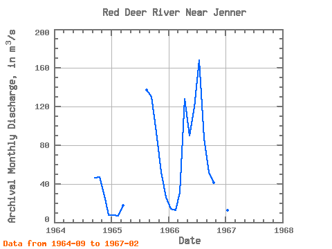
| Year | Jan | Feb | Mar | Apr | May | Jun | Jul | Aug | Sep | Oct | Nov | Dec | Annual | 1964 | 46.40 | 47.20 | 27.30 | 7.76 | 1965 | 7.43 | 6.95 | 17.90 | 137.00 | 130.00 | 93.40 | 52.10 | 26.40 | 1966 | 13.90 | 12.90 | 31.00 | 128.00 | 90.00 | 119.00 | 168.00 | 87.20 | 51.80 | 41.00 | 15.70 | 11.00 | 64.12 | 1967 | 12.80 | 11.40 |
|---|
 Return to R-Arctic Net Home Page