|
|
|||||||||||||||||
| Point ID: 430 | Downloads | Plots | Site Data | Code: 05CJ009 |
|
|
|||||||||||||||||
| Download | |
|---|---|
| Site Descriptor Information | Site Time Series Data |
| Link to all available data | |
|
|
| View: | Statistics | Time Series |
| Units: | m3/s |
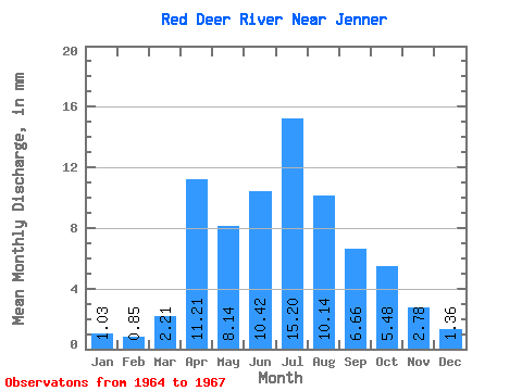
| Statistic | Jan | Feb | Mar | Apr | May | Jun | Jul | Aug | Sep | Oct | Nov | Dec | Annual |
|---|---|---|---|---|---|---|---|---|---|---|---|---|---|
| Mean | 0.74 | 0.62 | 1.60 | 8.09 | 5.88 | 7.52 | 10.97 | 7.32 | 4.81 | 3.95 | 2.00 | 0.98 | 49.36 |
| Standard Deviation | 0.23 | 0.18 | 0.60 | 2.30 | 2.96 | 1.87 | 1.18 | 0.65 | |||||
| Min | 0.48 | 0.41 | 1.17 | 8.09 | 5.88 | 7.52 | 10.97 | 5.70 | 2.93 | 2.68 | 0.99 | 0.51 | 49.36 |
| Max | 0.91 | 0.77 | 2.02 | 8.09 | 5.88 | 7.52 | 10.97 | 8.95 | 8.22 | 6.10 | 3.29 | 1.72 | 49.36 |
| Coefficient of Variation | 0.30 | 0.30 | 0.38 | 0.31 | 0.61 | 0.47 | 0.59 | 0.66 |
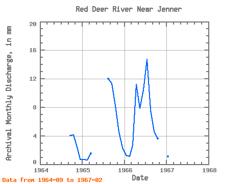
| Year | Jan | Feb | Mar | Apr | May | Jun | Jul | Aug | Sep | Oct | Nov | Dec | Annual | 1964 | 2.93 | 3.08 | 1.73 | 0.51 | 1965 | 0.48 | 0.41 | 1.17 | 8.95 | 8.22 | 6.10 | 3.29 | 1.72 | 1966 | 0.91 | 0.77 | 2.02 | 8.09 | 5.88 | 7.52 | 10.97 | 5.70 | 3.27 | 2.68 | 0.99 | 0.72 | 49.36 | 1967 | 0.84 | 0.68 |
|---|
 Return to R-Arctic Net Home Page