|
|
|||||||||||||||||
| Point ID: 392 | Downloads | Plots | Site Data | Code: 05CE007 |
|
|
|||||||||||||||||
| Download | |
|---|---|
| Site Descriptor Information | Site Time Series Data |
| Link to all available data | |
| View: | Time Series | All |
| Units: | m3/s |
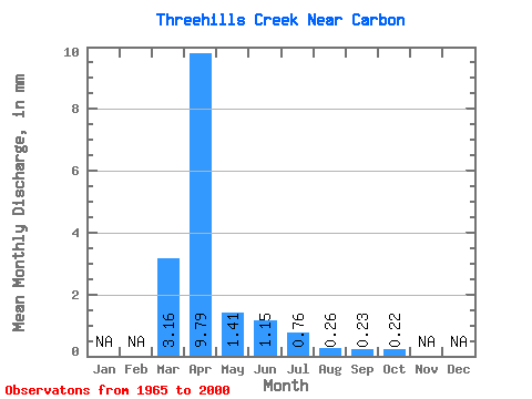
| Statistic | Jan | Feb | Mar | Apr | May | Jun | Jul | Aug | Sep | Oct | Nov | Dec | Annual |
|---|---|---|---|---|---|---|---|---|---|---|---|---|---|
| Mean | 2.95 | 9.14 | 1.32 | 1.08 | 0.71 | 0.24 | 0.22 | 0.21 | |||||
| Standard Deviation | 4.22 | 12.36 | 1.97 | 1.93 | 1.17 | 0.28 | 0.35 | 0.21 | |||||
| Min | 0.00 | 0.25 | 0.05 | 0.01 | 0.01 | 0.00 | 0.00 | 0.00 | |||||
| Max | 17.04 | 42.88 | 10.61 | 10.71 | 6.53 | 1.46 | 1.65 | 1.07 | |||||
| Coefficient of Variation | 1.43 | 1.35 | 1.50 | 1.79 | 1.65 | 1.16 | 1.59 | 1.01 |
 Return to R-Arctic Net Home Page