|
|
|||||||||||||||||
| Point ID: 392 | Downloads | Plots | Site Data | Code: 05CE007 |
|
|
|||||||||||||||||
| Download | |
|---|---|
| Site Descriptor Information | Site Time Series Data |
| Link to all available data | |
| View: | Time Series | All |
| Units: | mm |
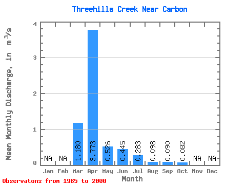
| Statistic | Jan | Feb | Mar | Apr | May | Jun | Jul | Aug | Sep | Oct | Nov | Dec | Annual |
|---|---|---|---|---|---|---|---|---|---|---|---|---|---|
| Mean | 1.18 | 3.77 | 0.53 | 0.45 | 0.28 | 0.10 | 0.09 | 0.08 | |||||
| Standard Deviation | 1.69 | 5.10 | 0.79 | 0.80 | 0.47 | 0.11 | 0.14 | 0.08 | |||||
| Min | 0.00 | 0.10 | 0.02 | 0.01 | 0.01 | 0.00 | 0.00 | 0.00 | |||||
| Max | 6.81 | 17.70 | 4.24 | 4.42 | 2.61 | 0.58 | 0.68 | 0.43 | |||||
| Coefficient of Variation | 1.43 | 1.35 | 1.50 | 1.79 | 1.65 | 1.16 | 1.59 | 1.01 |
 Return to R-Arctic Net Home Page