|
|
|||||||||||||||||
| Point ID: 3649 | Downloads | Plots | Site Data | Code: 10KD004 |
|
|
|||||||||||||||||
| Download | |
|---|---|
| Site Descriptor Information | Site Time Series Data |
| Link to all available data | |
| View: | Time Series | All |
| Units: | m3/s |
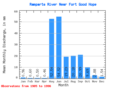
| Statistic | Jan | Feb | Mar | Apr | May | Jun | Jul | Aug | Sep | Oct | Nov | Dec | Annual |
|---|---|---|---|---|---|---|---|---|---|---|---|---|---|
| Mean | 0.96 | 0.61 | 0.50 | 0.46 | 52.53 | 54.52 | 19.23 | 20.18 | 20.99 | 9.69 | 2.88 | 1.54 | 177.32 |
| Standard Deviation | 0.26 | 0.19 | 0.19 | 0.12 | 13.53 | 23.27 | 6.35 | 11.50 | 11.78 | 4.55 | 1.19 | 0.48 | 27.38 |
| Min | 0.49 | 0.22 | 0.14 | 0.26 | 37.59 | 24.70 | 8.42 | 9.18 | 3.74 | 1.88 | 1.08 | 0.75 | 143.99 |
| Max | 1.39 | 0.86 | 0.75 | 0.69 | 81.68 | 98.99 | 28.95 | 44.81 | 47.57 | 15.97 | 5.07 | 2.36 | 245.42 |
| Coefficient of Variation | 0.27 | 0.30 | 0.38 | 0.27 | 0.26 | 0.43 | 0.33 | 0.57 | 0.56 | 0.47 | 0.41 | 0.31 | 0.15 |
 Return to R-Arctic Net Home Page