|
|
|||||||||||||||||
| Point ID: 3649 | Downloads | Plots | Site Data | Code: 10KD004 |
|
|
|||||||||||||||||
| Download | |
|---|---|
| Site Descriptor Information | Site Time Series Data |
| Link to all available data | |
| View: | Time Series | All |
| Units: | mm |
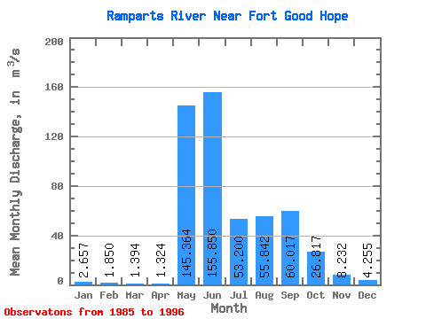
| Statistic | Jan | Feb | Mar | Apr | May | Jun | Jul | Aug | Sep | Oct | Nov | Dec | Annual |
|---|---|---|---|---|---|---|---|---|---|---|---|---|---|
| Mean | 2.66 | 1.85 | 1.39 | 1.32 | 145.36 | 155.85 | 53.20 | 55.84 | 60.02 | 26.82 | 8.23 | 4.25 | 41.63 |
| Standard Deviation | 0.71 | 0.56 | 0.53 | 0.36 | 37.43 | 66.53 | 17.58 | 31.82 | 33.67 | 12.59 | 3.41 | 1.34 | 6.43 |
| Min | 1.36 | 0.67 | 0.40 | 0.76 | 104.00 | 70.60 | 23.30 | 25.40 | 10.70 | 5.21 | 3.10 | 2.08 | 33.81 |
| Max | 3.84 | 2.62 | 2.08 | 1.98 | 226.00 | 283.00 | 80.10 | 124.00 | 136.00 | 44.20 | 14.50 | 6.54 | 57.62 |
| Coefficient of Variation | 0.27 | 0.30 | 0.38 | 0.27 | 0.26 | 0.43 | 0.33 | 0.57 | 0.56 | 0.47 | 0.41 | 0.31 | 0.15 |
 Return to R-Arctic Net Home Page