|
|
|||||||||||||||||
| Point ID: 3649 | Downloads | Plots | Site Data | Code: 10KD004 |
|
|
|||||||||||||||||
| Download | |
|---|---|
| Site Descriptor Information | Site Time Series Data |
| Link to all available data | |
|
|
| View: | Statistics | Time Series |
| Units: | mm |
| Statistic | Jan | Feb | Mar | Apr | May | Jun | Jul | Aug | Sep | Oct | Nov | Dec | Annual |
|---|---|---|---|---|---|---|---|---|---|---|---|---|---|
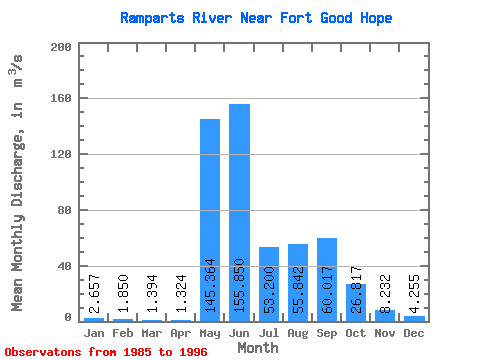
| Mean | 2.66 | 1.85 | 1.39 | 1.32 | 145.36 | 155.85 | 53.20 | 55.84 | 60.02 | 26.82 | 8.23 | 4.25 | 41.63 |
| Standard Deviation | 0.71 | 0.56 | 0.53 | 0.36 | 37.43 | 66.53 | 17.58 | 31.82 | 33.67 | 12.59 | 3.41 | 1.34 | 6.43 |
| Min | 1.36 | 0.67 | 0.40 | 0.76 | 104.00 | 70.60 | 23.30 | 25.40 | 10.70 | 5.21 | 3.10 | 2.08 | 33.81 |
| Max | 3.84 | 2.62 | 2.08 | 1.98 | 226.00 | 283.00 | 80.10 | 124.00 | 136.00 | 44.20 | 14.50 | 6.54 | 57.62 |
| Coefficient of Variation | 0.27 | 0.30 | 0.38 | 0.27 | 0.26 | 0.43 | 0.33 | 0.57 | 0.56 | 0.47 | 0.41 | 0.31 | 0.15 |
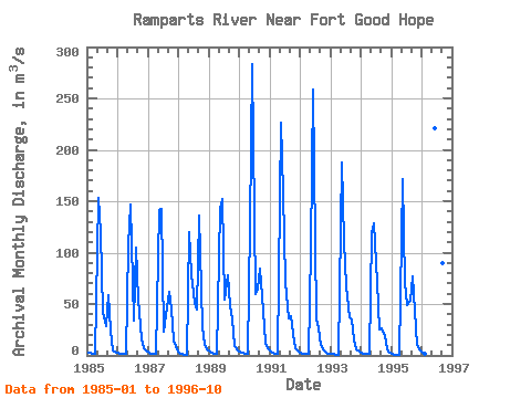
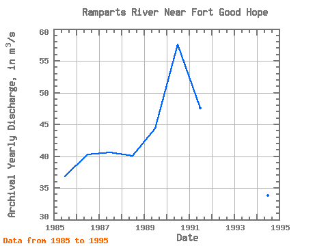
| Year | Jan | Feb | Mar | Apr | May | Jun | Jul | Aug | Sep | Oct | Nov | Dec | Annual | 1985 | 2.98 | 2.16 | 1.49 | 1.40 | 153.00 | 120.00 | 41.10 | 29.00 | 58.60 | 23.70 | 4.85 | 3.21 | 36.79 | 1986 | 2.43 | 1.98 | 1.72 | 1.61 | 107.00 | 147.00 | 33.50 | 105.00 | 54.70 | 16.50 | 7.41 | 4.42 | 40.27 | 1987 | 3.03 | 2.03 | 1.31 | 1.09 | 141.00 | 142.00 | 23.30 | 46.50 | 62.10 | 44.20 | 14.50 | 5.40 | 40.54 | 1988 | 2.68 | 1.47 | 0.71 | 0.76 | 120.00 | 78.60 | 51.40 | 45.10 | 136.00 | 28.50 | 10.30 | 5.65 | 40.10 | 1989 | 3.35 | 2.17 | 1.58 | 1.43 | 143.00 | 152.00 | 54.80 | 77.80 | 47.60 | 34.60 | 9.20 | 5.01 | 44.38 | 1990 | 3.39 | 2.62 | 1.93 | 1.48 | 126.00 | 283.00 | 59.80 | 65.50 | 84.90 | 43.80 | 12.50 | 6.54 | 57.62 | 1991 | 3.84 | 2.62 | 2.08 | 1.98 | 226.00 | 158.00 | 71.60 | 36.10 | 38.00 | 20.50 | 6.63 | 3.79 | 47.59 | 1992 | 2.54 | 2.01 | 1.82 | 1.51 | 104.00 | 259.00 | 35.70 | 26.00 | 10.70 | 5.21 | 3.10 | 2.08 | 37.81 | 1993 | 1.67 | 1.23 | 0.89 | 0.99 | 188.00 | 110.00 | 67.40 | 36.90 | 34.80 | 15.50 | 6.19 | 3.46 | 38.92 | 1994 | 2.32 | 1.72 | 1.41 | 1.44 | 119.00 | 129.00 | 71.30 | 25.40 | 26.10 | 19.30 | 5.88 | 2.81 | 33.81 | 1995 | 1.36 | 0.67 | 0.40 | 0.88 | 172.00 | 70.60 | 48.40 | 52.80 | 76.40 | 43.60 | 9.99 | 4.44 | 40.13 | 1996 | 2.30 | 1.52 | 221.00 | 80.10 | 124.00 | 90.30 | 26.40 |
|---|
 Return to R-Arctic Net Home Page