|
|
|||||||||||||||||
| Point ID: 3627 | Downloads | Plots | Site Data | Code: 10HA003 |
|
|
|||||||||||||||||
| Download | |
|---|---|
| Site Descriptor Information | Site Time Series Data |
| Link to all available data | |
| View: | Time Series | All |
| Units: | m3/s |
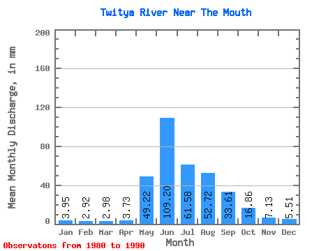
| Statistic | Jan | Feb | Mar | Apr | May | Jun | Jul | Aug | Sep | Oct | Nov | Dec | Annual |
|---|---|---|---|---|---|---|---|---|---|---|---|---|---|
| Mean | 3.95 | 2.94 | 2.98 | 3.73 | 49.21 | 109.20 | 61.58 | 52.71 | 33.61 | 16.86 | 7.13 | 5.51 | 348.11 |
| Standard Deviation | 0.69 | 0.84 | 0.80 | 1.81 | 21.38 | 19.79 | 15.37 | 14.05 | 12.13 | 4.01 | 1.47 | 1.09 | 34.27 |
| Min | 3.33 | 1.88 | 1.85 | 1.84 | 16.14 | 66.77 | 38.47 | 24.53 | 17.90 | 12.55 | 5.38 | 4.06 | 280.68 |
| Max | 5.27 | 4.41 | 4.01 | 7.65 | 88.63 | 134.00 | 90.54 | 72.34 | 61.21 | 24.53 | 9.51 | 7.67 | 384.38 |
| Coefficient of Variation | 0.17 | 0.29 | 0.27 | 0.48 | 0.43 | 0.18 | 0.25 | 0.27 | 0.36 | 0.24 | 0.21 | 0.20 | 0.10 |
 Return to R-Arctic Net Home Page