|
|
|||||||||||||||||
| Point ID: 3627 | Downloads | Plots | Site Data | Code: 10HA003 |
|
|
|||||||||||||||||
| Download | |
|---|---|
| Site Descriptor Information | Site Time Series Data |
| Link to all available data | |
| View: | Time Series | All |
| Units: | mm |
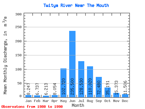
| Statistic | Jan | Feb | Mar | Apr | May | Jun | Jul | Aug | Sep | Oct | Nov | Dec | Annual |
|---|---|---|---|---|---|---|---|---|---|---|---|---|---|
| Mean | 8.25 | 6.74 | 6.21 | 8.05 | 102.72 | 235.50 | 128.53 | 110.02 | 72.48 | 35.19 | 15.37 | 11.51 | 61.66 |
| Standard Deviation | 1.43 | 1.93 | 1.68 | 3.90 | 44.64 | 42.68 | 32.08 | 29.34 | 26.16 | 8.38 | 3.17 | 2.27 | 6.07 |
| Min | 6.95 | 4.30 | 3.86 | 3.98 | 33.70 | 144.00 | 80.30 | 51.20 | 38.60 | 26.20 | 11.60 | 8.48 | 49.72 |
| Max | 11.00 | 10.10 | 8.38 | 16.50 | 185.00 | 289.00 | 189.00 | 151.00 | 132.00 | 51.20 | 20.50 | 16.00 | 68.08 |
| Coefficient of Variation | 0.17 | 0.29 | 0.27 | 0.48 | 0.43 | 0.18 | 0.25 | 0.27 | 0.36 | 0.24 | 0.21 | 0.20 | 0.10 |
 Return to R-Arctic Net Home Page