|
|
|||||||||||||||||
| Point ID: 3551 | Downloads | Plots | Site Data | Code: 06OA006 |
|
|
|||||||||||||||||
| Download | |
|---|---|
| Site Descriptor Information | Site Time Series Data |
| Link to all available data | |
|
|
| View: | Statistics | Time Series |
| Units: | mm |
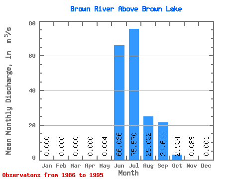
| Statistic | Jan | Feb | Mar | Apr | May | Jun | Jul | Aug | Sep | Oct | Nov | Dec | Annual |
|---|---|---|---|---|---|---|---|---|---|---|---|---|---|
| Mean | 0.00 | 0.00 | 0.00 | 0.00 | 0.00 | 66.04 | 75.57 | 25.03 | 21.61 | 2.93 | 0.09 | 0.00 | 15.91 |
| Standard Deviation | 0.00 | 0.00 | 0.00 | 0.00 | 0.01 | 39.42 | 49.45 | 14.56 | 14.84 | 2.37 | 0.13 | 0.00 | 1.94 |
| Min | 0.00 | 0.00 | 0.00 | 0.00 | 0.00 | 2.46 | 20.30 | 8.32 | 6.06 | 0.98 | 0.01 | 0.00 | 13.63 |
| Max | 0.00 | 0.00 | 0.00 | 0.00 | 0.03 | 124.00 | 163.00 | 51.00 | 55.20 | 8.19 | 0.43 | 0.01 | 19.84 |
| Coefficient of Variation | 2.25 | 0.60 | 0.65 | 0.58 | 0.69 | 0.81 | 1.50 | 3.00 | 0.12 |
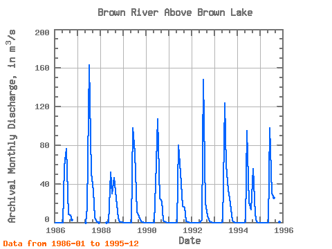
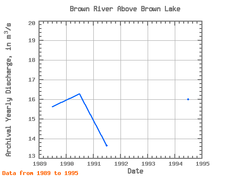
| Year | Jan | Feb | Mar | Apr | May | Jun | Jul | Aug | Sep | Oct | Nov | Dec | Annual | 1986 | 0.00 | 0.00 | 0.00 | 0.00 | 0.00 | 57.40 | 76.00 | 8.32 | 7.55 | 2.52 | 1987 | 0.00 | 15.10 | 163.00 | 51.00 | 32.50 | 5.42 | 0.03 | 0.00 | 1988 | 0.00 | 0.00 | 51.80 | 29.40 | 46.20 | 25.00 | 4.50 | 0.43 | 0.01 | 1989 | 0.00 | 0.00 | 0.00 | 0.00 | 0.00 | 97.50 | 71.70 | 11.10 | 6.06 | 1.07 | 0.01 | 0.00 | 15.62 | 1990 | 0.00 | 0.00 | 0.00 | 0.00 | 0.00 | 39.70 | 107.00 | 24.80 | 22.20 | 1.66 | 0.01 | 0.00 | 16.28 | 1991 | 0.00 | 0.00 | 0.00 | 0.00 | 0.00 | 79.70 | 50.90 | 16.50 | 15.50 | 0.98 | 0.02 | 0.00 | 13.63 | 1992 | 0.00 | 0.00 | 0.00 | 0.00 | 0.00 | 2.46 | 148.00 | 19.70 | 6.70 | 1.32 | 0.04 | 0.00 | 14.85 | 1993 | 0.00 | 0.00 | 0.00 | 0.00 | 0.03 | 124.00 | 59.00 | 33.70 | 19.40 | 1.91 | 0.10 | 0.00 | 19.84 | 1994 | 0.00 | 0.00 | 0.00 | 0.00 | 0.01 | 94.70 | 20.30 | 13.40 | 55.20 | 8.19 | 0.11 | 0.00 | 15.99 | 1995 | 0.00 | 0.00 | 0.00 | 0.00 | 0.00 | 98.00 | 30.40 | 25.60 | 26.00 | 1.77 | 0.04 | 0.00 | 15.15 |
|---|
 Return to R-Arctic Net Home Page