|
|
|||||||||||||||||
| Point ID: 3525 | Downloads | Plots | Site Data | Code: 06HB002 |
|
|
|||||||||||||||||
| Download | |
|---|---|
| Site Descriptor Information | Site Time Series Data |
| Link to all available data | |
|
|
| View: | Statistics | Time Series |
| Units: | mm |
| Statistic | Jan | Feb | Mar | Apr | May | Jun | Jul | Aug | Sep | Oct | Nov | Dec | Annual |
|---|---|---|---|---|---|---|---|---|---|---|---|---|---|
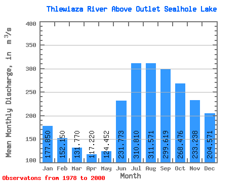
| Mean | 177.85 | 152.15 | 131.77 | 117.22 | 124.45 | 231.77 | 310.81 | 311.57 | 299.62 | 268.48 | 233.24 | 204.57 | 218.24 |
| Standard Deviation | 42.24 | 34.89 | 27.46 | 22.91 | 32.45 | 66.69 | 96.29 | 79.68 | 88.31 | 85.65 | 67.24 | 53.15 | 32.26 |
| Min | 124.00 | 108.00 | 98.40 | 87.10 | 81.80 | 116.00 | 126.00 | 130.00 | 155.00 | 163.00 | 145.00 | 136.00 | 165.33 |
| Max | 273.00 | 228.00 | 186.00 | 158.00 | 207.00 | 365.00 | 530.00 | 489.00 | 576.00 | 579.00 | 450.00 | 346.00 | 273.92 |
| Coefficient of Variation | 0.24 | 0.23 | 0.21 | 0.20 | 0.26 | 0.29 | 0.31 | 0.26 | 0.29 | 0.32 | 0.29 | 0.26 | 0.15 |
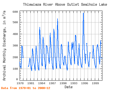
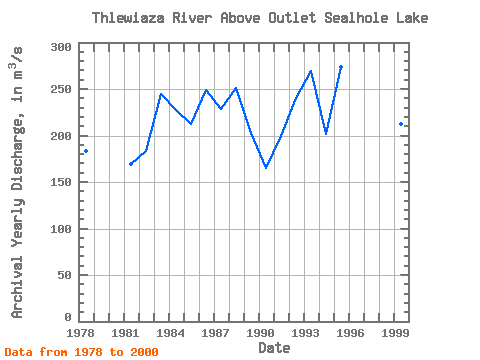
| Year | Jan | Feb | Mar | Apr | May | Jun | Jul | Aug | Sep | Oct | Nov | Dec | Annual | 1978 | 159.00 | 137.00 | 118.00 | 110.00 | 107.00 | 116.00 | 174.00 | 295.00 | 293.00 | 265.00 | 226.00 | 196.00 | 183.00 | 1980 | 121.00 | 126.00 | 130.00 | 155.00 | 183.00 | 192.00 | 166.00 | 1981 | 143.00 | 123.00 | 106.00 | 90.10 | 81.80 | 166.00 | 258.00 | 274.00 | 241.00 | 207.00 | 181.00 | 159.00 | 169.16 | 1982 | 145.00 | 124.00 | 106.00 | 90.50 | 85.50 | 208.00 | 296.00 | 289.00 | 258.00 | 241.00 | 193.00 | 161.00 | 183.08 | 1983 | 141.00 | 120.00 | 107.00 | 94.00 | 86.40 | 222.00 | 420.00 | 458.00 | 408.00 | 342.00 | 284.00 | 251.00 | 244.45 | 1984 | 207.00 | 163.00 | 139.00 | 123.00 | 129.00 | 324.00 | 373.00 | 340.00 | 301.00 | 252.00 | 197.00 | 179.00 | 227.25 | 1985 | 155.00 | 122.00 | 105.00 | 96.20 | 155.00 | 300.00 | 296.00 | 296.00 | 282.00 | 268.00 | 245.00 | 223.00 | 211.93 | 1986 | 201.00 | 179.00 | 161.00 | 144.00 | 207.00 | 365.00 | 408.00 | 332.00 | 327.00 | 257.00 | 216.00 | 187.00 | 248.67 | 1987 | 159.00 | 131.00 | 111.00 | 96.50 | 93.80 | 297.00 | 442.00 | 411.00 | 334.00 | 260.00 | 215.00 | 186.00 | 228.03 | 1988 | 163.00 | 134.00 | 111.00 | 103.00 | 106.00 | 297.00 | 530.00 | 489.00 | 382.00 | 298.00 | 214.00 | 180.00 | 250.58 | 1989 | 151.00 | 131.00 | 117.00 | 107.00 | 103.00 | 165.00 | 291.00 | 302.00 | 310.00 | 290.00 | 243.00 | 219.00 | 202.42 | 1990 | 188.00 | 161.00 | 140.00 | 132.00 | 131.00 | 179.00 | 204.00 | 209.00 | 196.00 | 163.00 | 145.00 | 136.00 | 165.33 | 1991 | 124.00 | 108.00 | 98.40 | 87.10 | 102.00 | 253.00 | 332.00 | 323.00 | 271.00 | 246.00 | 236.00 | 218.00 | 199.88 | 1992 | 198.00 | 183.00 | 162.00 | 142.00 | 132.00 | 239.00 | 323.00 | 299.00 | 266.00 | 303.00 | 330.00 | 309.00 | 240.50 | 1993 | 270.00 | 228.00 | 181.00 | 150.00 | 141.00 | 283.00 | 387.00 | 389.00 | 368.00 | 316.00 | 282.00 | 241.00 | 269.67 | 1994 | 202.00 | 173.00 | 147.00 | 133.00 | 128.00 | 237.00 | 318.00 | 291.00 | 240.00 | 208.00 | 183.00 | 165.00 | 202.08 | 1995 | 153.00 | 140.00 | 129.00 | 113.00 | 108.00 | 163.00 | 208.00 | 322.00 | 576.00 | 579.00 | 450.00 | 346.00 | 273.92 | 1996 | 273.00 | 225.00 | 186.00 | 158.00 | 142.00 | 222.00 | 318.00 | 272.00 | 235.00 | 198.00 | 1997 | 167.00 | 149.00 | 133.00 | 121.00 | 116.00 | 177.00 | 222.00 | 238.00 | 1998 | 193.00 | 303.00 | 298.00 | 245.00 | 205.00 | 177.00 | 156.00 | 144.00 | 1999 | 132.00 | 120.00 | 110.00 | 104.00 | 127.00 | 235.00 | 279.00 | 296.00 | 309.00 | 299.00 | 283.00 | 259.00 | 212.75 | 2000 | 226.00 | 192.00 | 168.00 | 150.00 | 139.00 | 227.00 | 342.00 | 315.00 | 252.00 | 212.00 | 192.00 | 173.00 | 215.67 |
|---|
 Return to R-Arctic Net Home Page