|
|
|||||||||||||||||
| Point ID: 3525 | Downloads | Plots | Site Data | Code: 06HB002 |
|
|
|||||||||||||||||
| Download | |
|---|---|
| Site Descriptor Information | Site Time Series Data |
| Link to all available data | |
| View: | Time Series | All |
| Units: | mm |
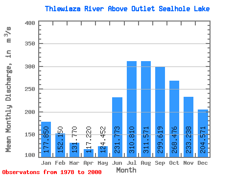
| Statistic | Jan | Feb | Mar | Apr | May | Jun | Jul | Aug | Sep | Oct | Nov | Dec | Annual |
|---|---|---|---|---|---|---|---|---|---|---|---|---|---|
| Mean | 177.85 | 152.15 | 131.77 | 117.22 | 124.45 | 231.77 | 310.81 | 311.57 | 299.62 | 268.48 | 233.24 | 204.57 | 218.24 |
| Standard Deviation | 42.24 | 34.89 | 27.46 | 22.91 | 32.45 | 66.69 | 96.29 | 79.68 | 88.31 | 85.65 | 67.24 | 53.15 | 32.26 |
| Min | 124.00 | 108.00 | 98.40 | 87.10 | 81.80 | 116.00 | 126.00 | 130.00 | 155.00 | 163.00 | 145.00 | 136.00 | 165.33 |
| Max | 273.00 | 228.00 | 186.00 | 158.00 | 207.00 | 365.00 | 530.00 | 489.00 | 576.00 | 579.00 | 450.00 | 346.00 | 273.92 |
| Coefficient of Variation | 0.24 | 0.23 | 0.21 | 0.20 | 0.26 | 0.29 | 0.31 | 0.26 | 0.29 | 0.32 | 0.29 | 0.26 | 0.15 |
 Return to R-Arctic Net Home Page