|
|
|||||||||||||||||
| Point ID: 326 | Downloads | Plots | Site Data | Code: 05BM004 |
|
|
|||||||||||||||||
| Download | |
|---|---|
| Site Descriptor Information | Site Time Series Data |
| Link to all available data | |
|
|
| View: | Statistics | Time Series |
| Units: | mm |
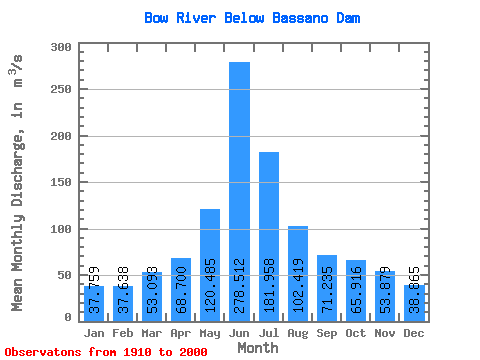
| Statistic | Jan | Feb | Mar | Apr | May | Jun | Jul | Aug | Sep | Oct | Nov | Dec | Annual |
|---|---|---|---|---|---|---|---|---|---|---|---|---|---|
| Mean | 37.76 | 37.64 | 53.09 | 68.70 | 120.48 | 278.51 | 181.96 | 102.42 | 71.23 | 65.92 | 53.88 | 38.87 | 124.60 |
| Standard Deviation | 9.81 | 8.20 | 22.20 | 25.49 | 63.85 | 176.32 | 147.17 | 80.28 | 62.09 | 37.29 | 16.01 | 10.54 | 44.52 |
| Min | 28.20 | 27.20 | 28.50 | 7.99 | 4.63 | 17.80 | 4.64 | 7.73 | 6.95 | 7.09 | 34.70 | 25.30 | 81.12 |
| Max | 68.40 | 52.00 | 119.00 | 131.00 | 273.00 | 851.00 | 772.00 | 352.00 | 292.00 | 188.00 | 84.70 | 63.70 | 229.36 |
| Coefficient of Variation | 0.26 | 0.22 | 0.42 | 0.37 | 0.53 | 0.63 | 0.81 | 0.78 | 0.87 | 0.57 | 0.30 | 0.27 | 0.36 |
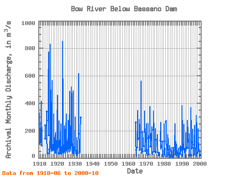
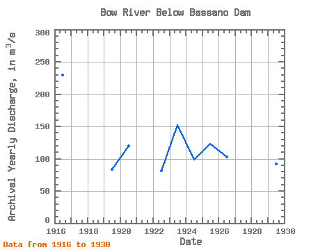
| Year | Jan | Feb | Mar | Apr | May | Jun | Jul | Aug | Sep | Oct | Nov | Dec | Annual | 1910 | 329.00 | 260.00 | 174.00 | 123.00 | 108.00 | 1911 | 115.00 | 415.00 | 307.00 | 271.00 | 180.00 | 92.90 | 1913 | 239.00 | 142.00 | 1914 | 339.00 | 246.00 | 132.00 | 77.90 | 88.90 | 63.10 | 29.10 | 1915 | 35.70 | 273.00 | 523.00 | 772.00 | 352.00 | 167.00 | 62.60 | 38.40 | 1916 | 28.20 | 33.00 | 55.20 | 83.20 | 162.00 | 831.00 | 653.00 | 344.00 | 292.00 | 140.00 | 79.40 | 51.30 | 229.36 | 1917 | 46.80 | 51.10 | 58.50 | 55.60 | 248.00 | 566.00 | 349.00 | 182.00 | 118.00 | 86.00 | 54.10 | 1918 | 66.50 | 103.00 | 319.00 | 163.00 | 137.00 | 79.20 | 69.40 | 45.60 | 38.90 | 1919 | 45.80 | 35.20 | 33.50 | 61.90 | 152.00 | 186.00 | 109.00 | 178.00 | 75.80 | 51.40 | 39.00 | 34.40 | 83.50 | 1920 | 32.10 | 30.10 | 43.90 | 82.50 | 197.00 | 246.00 | 456.00 | 149.00 | 65.20 | 63.90 | 41.50 | 30.00 | 119.77 | 1921 | 37.80 | 33.60 | 79.60 | 166.00 | 272.00 | 159.00 | 103.00 | 28.80 | 42.30 | 36.70 | 34.90 | 1922 | 32.00 | 27.20 | 32.40 | 66.30 | 139.00 | 249.00 | 139.00 | 104.00 | 64.80 | 53.40 | 41.10 | 25.30 | 81.12 | 1923 | 31.20 | 27.60 | 28.50 | 48.40 | 80.60 | 851.00 | 303.00 | 189.00 | 94.60 | 82.60 | 50.90 | 34.60 | 151.83 | 1924 | 32.80 | 40.20 | 36.20 | 62.40 | 136.00 | 236.00 | 202.00 | 210.00 | 80.60 | 64.30 | 51.20 | 32.90 | 98.72 | 1925 | 43.30 | 39.00 | 68.50 | 131.00 | 193.00 | 322.00 | 179.00 | 147.00 | 105.00 | 122.00 | 76.60 | 54.10 | 123.38 | 1926 | 38.40 | 45.30 | 65.90 | 82.30 | 68.00 | 132.00 | 143.00 | 75.40 | 273.00 | 164.00 | 80.90 | 63.70 | 102.66 | 1927 | 43.10 | 44.80 | 60.40 | 92.40 | 147.00 | 487.00 | 341.00 | 213.00 | 233.00 | 188.00 | 84.70 | 53.30 | 165.64 | 1928 | 68.40 | 52.00 | 119.00 | 102.00 | 199.00 | 519.00 | 426.00 | 175.00 | 90.00 | 79.70 | 49.90 | 34.30 | 159.53 | 1929 | 32.70 | 34.00 | 48.90 | 72.60 | 139.00 | 490.00 | 89.90 | 70.80 | 36.50 | 16.80 | 42.30 | 30.30 | 91.98 | 1930 | 28.80 | 46.90 | 59.80 | 66.70 | 101.00 | 301.00 | 195.00 | 79.60 | 35.70 | 52.20 | 44.90 | 40.90 | 87.71 | 1931 | 30.90 | 29.00 | 45.20 | 47.10 | 19.30 | 150.00 | 109.00 | 46.60 | 45.20 | 50.70 | 34.70 | 1932 | 179.00 | 616.00 | 170.00 | 101.00 | 92.70 | 75.40 | 44.50 | 34.30 | 1933 | 33.90 | 33.20 | 40.50 | 101.00 | 196.00 | 295.00 | 1964 | 259.00 | 138.00 | 25.20 | 11.00 | 58.30 | 1965 | 78.80 | 306.00 | 347.00 | 153.00 | 136.00 | 141.00 | 1966 | 146.00 | 280.00 | 214.00 | 90.90 | 61.60 | 58.60 | 1967 | 188.00 | 561.00 | 186.00 | 61.50 | 66.60 | 38.60 | 1968 | 47.70 | 195.00 | 104.00 | 87.20 | 87.90 | 88.60 | 1969 | 190.00 | 302.00 | 343.00 | 82.50 | 51.20 | 52.50 | 1970 | 119.00 | 248.00 | 116.00 | 44.30 | 19.20 | 58.50 | 1971 | 146.00 | 253.00 | 73.60 | 61.20 | 21.70 | 28.50 | 1972 | 149.00 | 375.00 | 225.00 | 135.00 | 95.10 | 84.60 | 1973 | 131.00 | 229.00 | 114.00 | 36.40 | 27.40 | 40.80 | 1974 | 207.00 | 342.00 | 168.00 | 99.80 | 50.90 | 47.80 | 1975 | 134.00 | 212.00 | 120.00 | 39.40 | 35.90 | 49.80 | 1976 | 133.00 | 87.70 | 122.00 | 172.00 | 76.50 | 39.70 | 1977 | 20.40 | 40.30 | 15.40 | 40.10 | 22.00 | 31.20 | 1978 | 127.00 | 259.00 | 124.00 | 64.60 | 96.50 | 80.30 | 1979 | 120.00 | 89.10 | 23.40 | 18.10 | 11.60 | 14.20 | 1980 | 124.00 | 248.00 | 28.20 | 30.10 | 20.30 | 65.80 | 1981 | 265.00 | 273.00 | 239.00 | 154.00 | 45.70 | 11.00 | 1982 | 61.70 | 169.00 | 117.00 | 15.50 | 17.60 | 36.10 | 1983 | 62.70 | 91.50 | 69.10 | 20.00 | 6.95 | 7.09 | 1984 | 50.70 | 8.71 | 76.90 | 30.60 | 10.90 | 10.40 | 8.30 | 1985 | 72.60 | 48.60 | 40.20 | 4.64 | 7.73 | 52.60 | 59.10 | 1986 | 76.90 | 250.00 | 95.10 | 24.60 | 38.20 | 118.00 | 1987 | 55.00 | 103.00 | 17.80 | 39.10 | 33.40 | 47.00 | 38.80 | 1988 | 35.40 | 5.04 | 68.20 | 25.10 | 26.30 | 25.50 | 35.60 | 1989 | 72.60 | 39.20 | 86.70 | 26.50 | 34.40 | 64.00 | 76.50 | 1990 | 60.10 | 132.00 | 380.00 | 166.00 | 71.00 | 11.50 | 59.20 | 1991 | 65.90 | 143.00 | 244.00 | 247.00 | 101.00 | 36.90 | 64.10 | 1992 | 7.99 | 4.63 | 136.00 | 183.00 | 59.10 | 50.20 | 76.80 | 1993 | 72.90 | 118.00 | 178.00 | 274.00 | 178.00 | 161.00 | 120.00 | 1994 | 72.90 | 95.70 | 176.00 | 34.70 | 18.60 | 9.54 | 22.20 | 1995 | 20.30 | 135.00 | 368.00 | 180.00 | 88.80 | 67.10 | 75.00 | 1996 | 117.00 | 120.00 | 210.00 | 118.00 | 38.50 | 17.90 | 73.90 | 1997 | 98.20 | 87.60 | 238.00 | 22.20 | 34.00 | 38.60 | 65.00 | 1998 | 74.60 | 101.00 | 309.00 | 206.00 | 44.50 | 14.10 | 34.20 | 1999 | 36.20 | 53.00 | 139.00 | 213.00 | 150.00 | 74.70 | 63.60 | 2000 | 53.20 | 12.60 | 20.80 | 31.00 | 18.70 | 22.00 | 42.00 |
|---|
 Return to R-Arctic Net Home Page